Agua Azul
| Agua Azul | |
|---|---|
 | |
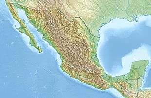 Location in Mexico | |
| Location | Tumbalá, Chiapas, Mexico |
| Coordinates | 17°15′21″N 92°06′57″W / 17.255704°N 92.115951°WCoordinates: 17°15′21″N 92°06′57″W / 17.255704°N 92.115951°W |
| Number of drops | Various |
| Longest drop | 6 m (20 ft) |
| Watercourse | Agua Azul river → Río Shumula → Río Tulijá → Río Chilapa → Río Grijalva[1] |
The Cascadas de Agua Azul (Spanish for "Blue Water Cascades") are a series of waterfalls found on the Xanil River in the southern Mexican state of Chiapas. They are located in the Municipality of Tumbalá, 69 kilometres (43 mi) from Palenque, near Mexican Federal Highway 199.
These waterfalls consists of many cataracts following one after another, taken from near the top of the sequence of cascades. The larger cataracts may be as high as 6 meters (20 feet) or so. During much of the distance the water descends in two streams, with small islands in the middle.
The water has a high content of calcium carbonate and other minerals, and where it falls on rocks or fallen trees, it encases them in a thick shell-like coating of limestone.[2]
Local residents reportedly restored the waterfalls[3] after the 2017 Chiapas earthquake has created a crack and led to a temporary reduction of the water flow over the falls.[4]
Gallery
 The series of Agua Azul cascades seen from the top
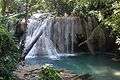 Trees in different stages of calcification
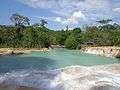 Xanil River basin
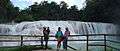
References
- ↑ "Archived copy" (PDF). Archived from the original (PDF) on 2016-03-13. Retrieved 2016-03-13.
- ↑ WorldTopTop.com. "Cascadas de Agua Azul – Top Waterfalls in the World". BBC. Retrieved November 18, 2017.
- ↑ BBC (November 17, 2017). "Mexico waterfall: Agua Azul cascades return to quake-hit river". BBC. Retrieved November 18, 2017.
- ↑ Ruptly (November 13, 2017). "Chasing waterfalls! Mystery abounds after Agua Azul falls dry up". YouTube. Retrieved Nov 14, 2017.