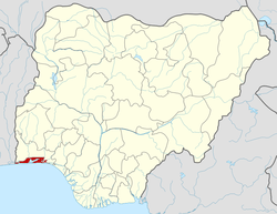
Agege
| Agege | |
|---|---|
| LGA and suburb | |
|
Location in Lagos Metropolitan Area | |
| Country |
|
| State | Lagos State |
| Government | |
| • Executive Chairman | Ganiyu Kola Egunjobi |
| Population (2006) | |
| • Total | 459,939 |
| Time zone | UTC+1 (WAT) |

Agege is a suburb and local government area in the Ikeja Division of Lagos State, Nigeria.
Etymology
When the kolanut plantations in the Agege area started to flourish it attracted huge settlements. Agege experienced rapid development and became a powerful center of the kolanut trade. These settlements attracted different people of different backgrounds and interests such as laborers, and most of these were Hausa. Whenever the Yorubas needed labourers for jobs such as cutting of trees, they would engage the services of the Hausa people. Because of this work the immediate area where the Hausas lived was named ‘Ilu Awon Ageigi’ which translates as ‘Town (Ilu) of the tree cutters’. The name Agege was thus formed out of the word Ageigi.[1]
Geography
The boundary of Agege from the Northern part of Lagos stretches from Dopemu road through Anu-oluwapo street to olukosi down Fagbola through Osobu street to Orile road down to Old Agege Motor Road opposite Nitel. From the Southern part of Lagos it stretches from Ashade retail market to Akilo street.[2]
From the Eastern part of Lagos it stretches from Oba ogunji road up to the by-pass to Agege Motor road by Nitel office. From the Western part of Lagos, the boundary of Agege stretches from Abeokuta express road from boundary with Ikeja Local government to Dopemu junction.[3]
Economy
When Dasab Airlines existed, its Lagos office was in Agege.[4]
History
The Agege Local Government was created in 1954 and was operative until 1967 after the first military takeover when it was merged with the Ikeja District council for a period of thirteen years. Agege was removed from the Ikeja Local Government in 1980 and remained so until 1983 when the Military took over power again and abolished the existing system of Local Government at the time . Again the Governance of Agege remained with Ikeja for another six (6) years. Subsequently there have been three other local governments carved out from Agege Local Government. They are: Alimosho, Ifako Ijaye and Orile-Agege Local Government Areas.
People
The inhabitants of Agege Local Government are multi-ethnic although the Awori are the indigenous inhabitants. Some major communities making up the Agege Local Government are Ogba, Asade, Dopemu, Atobaje, Gbogunleri, Isale Oja, Ajegunle, Sango, Keke, Papa uku/Olusanya, Oniwaya, Moricas, Iloro, Mangoro, Darocha, Onipetesi, Alfa Nla and Agbotikuyo. The inhabitants of Agege Local Government are essentially Yorubas with the presence of sparse population of non-Yoruba speaking people.[5]
Traditional Rulers
In Agege / Orile Agege, the Chieftaincy Community has three recognized Obas and Six traditional members.
Events
On 3 June 2012, Dana Air Flight 992 crashed into residential buildings in Agege while attempting to land at Murtala Muhammed International Airport, killing all 153 people on board and 10 other people on the ground.[6]
Education
It includes a campus of Lagos State University.[7]
National Youth Service Corps Permanent Orientation Camp is located at Iyana-Ipaja Road, Agege.[8]
See also
References
- ↑ "A place called Zangon Agege". Daily Trust.
- ↑ "Archived copy". Archived from the original on 2014-01-21. Retrieved 2014-01-26.
- ↑ "Archived copy". Archived from the original on 2014-01-21. Retrieved 2014-01-26.
- ↑ "Contact Us." Dasab Airlines. 11 July 2003. Retrieved on 12 September 2011. "Lagos Office 61, Abeokuta Express Road Agege, Lagos - Nigeria"
- ↑ "Welcome to Agege Local Government". 2007-09-29. Retrieved 2018-01-13.
- ↑ Urquhart, Conal (3 June 2012). "At least 147 Killed in Nigeria Plane Crash". The Guardian. London. Retrieved 3 June 2012.
- ↑ http://www.tribune.com.ng/22072007/news/news9.html%5Bpermanent+dead+link%5D
- ↑
External links
| Wikimedia Commons has media related to Agege. |
- Agege Local Government
- New School, NYC. Sustainable Cities Club blog post about Agege, Lagos
