Agar Town
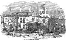
Agar Town (also known as Ague Town, Hagar Town, Agar-Town and Agar-town) was a short-lived area of St Pancras in central London. It was named after William Agar, a wealthy lawyer who lived at Elm Lodge, a villa in large grounds near to the Regent's Canal roughly where Barker Drive is now. Streets included Canterbury Place, Durham Street, and Oxford Crescent.[1] Agar Town, consisting of low-quality housing for poor people, built of the lowest quality materials on 21 year leases, with no street lighting or sewage, and a population of laborers living in houses they built for themselves, was generally considered a slum.[1] This designation has been questioned.[2]
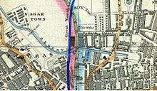
The neighbourhood was started in 1841 with Agar's widow leasing out small plots on the north side of the canal. Ownership passed to the Church Commissioners, who sold it to the Midland Railway. The company demolished most of the housing to make way for warehouses supplying St Pancras railway station from 1866.
The name of Agar Town is commemorated by Agar Grove, a road that runs along the edge of where Agar Town used to be, and which was originally called St Paul's Road, Camden Town.
Agar Town is sung about in the English Folk song The River Don't Run written by Richard Guard and Anna Crockatt most recently sung by Nick Hart on his album Nick Hart Sings Eight English Folk Songs. The song describes the demolition of Agar Town and the disappearance of the River Fleet as it was diverted underground to make way for St Pancras railway station.
See also
References
- 1 2 Tom Bolton (24 June 2015). "From Cripplegate to Agar Town: inside London's vanished neighbourhoods". The Guardian. Retrieved 24 June 2015.
The local vestry failed to provide "Ague Town", as it became known, with street lighting or cleaning, there was no sewerage, and it quickly became synonymous with mud and disease.
- ↑ Denford, Steven L J (1995) Agar Town: The life and death of a Victorian "slum". Camden History Society, London. Camden History Society website
External links
- Mapping Poverty in Agar Town: Economic Conditions Prior to the Development of St. Pancras Station In 1866
- Saint Thomas, Agar Town: Camden
- "Agar Town, Camden" on hidden-london.com
Coordinates: 51°32′20″N 0°7′55″W / 51.53889°N 0.13194°W