Afton, Oklahoma
| Afton, Oklahoma | |
|---|---|
| Town | |
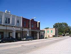 View of Route 66 in downtown Afton, Oklahoma | |
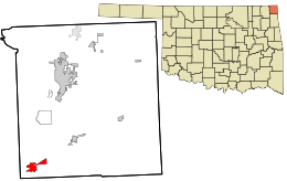 Location within Ottawa County and the state of Oklahoma | |
| Coordinates: 36°41′31″N 94°57′50″W / 36.69194°N 94.96389°WCoordinates: 36°41′31″N 94°57′50″W / 36.69194°N 94.96389°W | |
| Country | United States |
| State | Oklahoma |
| County | Ottawa |
| Area | |
| • Total | 1.7 sq mi (4.3 km2) |
| • Land | 1.7 sq mi (4.3 km2) |
| • Water | 0.0 sq mi (0.0 km2) |
| Elevation | 787 ft (240 m) |
| Population (2010)[1] | |
| • Total | 1,049 |
| • Density | 620/sq mi (240/km2) |
| Time zone | UTC-6 (Central (CST)) |
| • Summer (DST) | UTC-5 (CDT) |
| ZIP code | 74331 |
| Area code(s) | 539/918 |
| FIPS code | 40-00600[2] |
| GNIS feature ID | 1089546[3] |
Afton is a town in southwest Ottawa County, Oklahoma, United States. The population was 1,049 as of the 2010 census,[1] with population growth stemming from the near abandonment of nearby towns of Cardin and Picher because of ground contamination sites by local mining quarries. The town may have been named for the Scottish River Afton.[4]
History
Afton developed in this part of the Cherokee Nation in Indian Territory after the Atlantic and Pacific Railroad Company (later the St. Louis and San Francisco Railway, or Frisco) built tracks through the area to Vinita in 1871. According to Oklahoma historian George Shirk, a Scottish railroad surveyor, Anton Aires, named the town Afton after his daughter. Others have claimed the name comes from Robert Burns's poem, "Flow Gently Sweet Afton." Both Afton Aires' name and the Burns'poem honor the River Afton in Scotland.[4]
A post office was established in Afton during 1886. The 1900 census showed a population of 606. In 1901, the Kansas City, Fort Scott and Memphis Railroad, which soon became part of the Frisco system, constructed another line through the town, creating a shorter route to Kansas City, and causing another spurt of population growth. The town became a Frisco division point and shipping center for the surrounding agricultural area.{{efn/Agriculture mainly featured wheat, corn, hay and livestock.[4]}} In 1910, Afton's population was 1,276; the town had two school, a waterworks, two hotels, two banks, a brick and tile plant, a creamery, a newspaper, mills and grain elevators. The population peaked at 1,518 in 1920, but a depression after World War I caused a drop to 1,219 in 1930.[4]
Geography
Afton is located at 36°41′31″N 94°57′50″W / 36.69194°N 94.96389°W (36.691845, -94.964024).[5]
According to the United States Census Bureau, the town has a total area of 1.6 square miles (4.1 km2), all of it land.
Originally a farming and railroad community, Afton is located on the historic U.S. Route 66 in Oklahoma. Route 66 was bypassed by I-44 in 1957. Businesses which formerly served US 66 travellers in the town's heyday included the Palmer Hotel, Rogers’ Motel, Rest Haven Motel, Green Acres Motel and Avon Motor Court, Baker's Cafe, Clint's Cafe, Smith Store and Barrett's Food Store, Mack's Place and Fred's 66 Bar.[6]
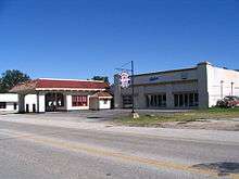
The Afton Station Packard Museum is housed in a former D-X filling station, built in 1937 and restored in 1999 to house Packard and U.S. Route 66 memorabilia.
Demographics
| Historical population | |||
|---|---|---|---|
| Census | Pop. | %± | |
| 1900 | 606 | — | |
| 1910 | 1,279 | 111.1% | |
| 1920 | 1,518 | 18.7% | |
| 1930 | 1,219 | −19.7% | |
| 1940 | 1,261 | 3.4% | |
| 1950 | 1,252 | −0.7% | |
| 1960 | 1,111 | −11.3% | |
| 1970 | 1,022 | −8.0% | |
| 1980 | 1,174 | 14.9% | |
| 1990 | 915 | −22.1% | |
| 2000 | 1,118 | 22.2% | |
| 2010 | 1,049 | −6.2% | |
| Est. 2015 | 1,050 | [7] | 0.1% |
| U.S. Decennial Census[8] | |||
Afton is part of the Joplin-Miami, MO-OK metropolitan area.
As of the census of 2010, there were 1,049 people residing in the town.[1] The population density was 620 people per square mile (240/km²). There were 488 housing units at an average density of 307.7 per square mile (119.1/km²). The racial makeup of the town was 77.46% White, 0.09% African American, 14.58% Native American, 0.09% Asian, and 7.78% from two or more races. Hispanic or Latino of any race were 1.70% of the population.
There were 441 households out of which 33.3% had children under the age of 18 living with them, 51.9% were married couples living together, 10.9% had a female householder with no husband present, and 31.5% were non-families. 29.7% of all households were made up of individuals and 15.6% had someone living alone who was 65 years of age or older. The average household size was 2.54 and the average family size was 3.11.
In the town, the population was spread out with 29.5% under the age of 18, 7.6% from 18 to 24, 25.7% from 25 to 44, 20.2% from 45 to 64, and 17.0% who were 65 years of age or older. The median age was 36 years. For every 100 females, there were 94.8 males. For every 100 females age 18 and over, there were 93.6 males.
The median income for a household in the town was $21,964, and the median income for a family was $28,036. Males had a median income of $22,361 versus $16,964 for females. The per capita income for the town was $11,032. About 15.9% of families and 21.0% of the population were below the poverty line, including 32.6% of those under age 18 and 5.1% of those age 65 or over.
Education
Afton is served by the Afton Independent School District. Northeast Technology Center operates a campus at 19901 S. Hwy 69.
Culture
- The Darryl Starbird National Rod and Custom Hall of Fame Museum hosts an anniversary celebration in Afton, every June.[4]
National Register of Historic Places
- Cities Service Station
- Horse Creek Bridge
References
- 1 2 3 "2010 City Population and Housing Occupancy Status". U.S. Census Bureau. Archived from the original on July 21, 2011. Retrieved October 18, 2013.
- ↑ "American FactFinder". United States Census Bureau. Archived from the original on 2013-09-11. Retrieved 2008-01-31.
- ↑ "US Board on Geographic Names". United States Geological Survey. 2007-10-25. Retrieved 2008-01-31.
- 1 2 3 4 5 Larry O'Dell, "Afton,".Encyclopedia of Oklahoma History and Culture. Accessed February 16, 2014.
- ↑ "US Gazetteer files: 2010, 2000, and 1990". United States Census Bureau. 2011-02-12. Retrieved 2011-04-23.
- ↑ "Afton recalls its Route 66 heyday" (PDF). Northeast Connection. Northeast Oklahoma Electric Cooperative. December 2011. Retrieved 2012-08-09.
- ↑ "Annual Estimates of the Resident Population for Incorporated Places: April 1, 2010 to July 1, 2015". Archived from the original on 2016-06-02. Retrieved July 2, 2016.
- ↑ "Census of Population and Housing". Census.gov. Archived from the original on May 12, 2015. Retrieved June 4, 2015.
External links
| Wikimedia Commons has media related to Afton, Oklahoma. |
- Afton information, photos and videos on TravelOK.com Official travel and tourism website for the State of Oklahoma
- "Afton", Encyclopedia of Oklahoma History and Culture
Municipalities and communities of Ottawa County, Oklahoma, United States | ||
|---|---|---|
| Cities | 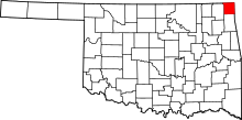 | |
| Towns | ||
| CDPs | ||
| Unincorporated communities | ||
| Ghost towns | ||