Afon Dwyfor
| Afon Dwyfor | |
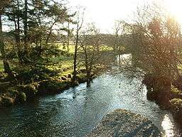 The Afon Dwyfor as it leaves Cwm Pennant | |
| Countries | United Kingdom, Wales |
|---|---|
| Coordinates | 52°57′47″N 4°13′03″W / 52.9631°N 4.2175°WCoordinates: 52°57′47″N 4°13′03″W / 52.9631°N 4.2175°W |
| Source | |
| - location | Cwm Dwyfor, Eifionydd Hills |
| - elevation | 460 ft (140 m) |
| - coordinates | 53°01′13″N 4°10′41″W / 53.0204°N 4.1780°W |
| Mouth | |
| - location | Tremadog Bay, Cardigan Bay |
| - elevation | 0 ft (0 m) |
| - coordinates | 52°54′38″N 4°15′38″W / 52.9105°N 4.2606°W |
| Length | 12.5 mi (20 km) |
The Afon Dwyfor is a river in Gwynedd, north-west Wales, in total the river is 12 1⁄2 miles (20.1 km) in length. It rises in Cwm Dwyfor at the head of Cwm Pennant, gathers to itself numerous streams which drain the surrounding mountains from Mynydd Graig Goch in the west to Moel Hebog in the east, then flows southwest towards Dolbenmaen and out of the Snowdonia National Park.[1]
After a brief diversion west, it turns south, then southwest again, heading for the village of Llanystumdwy. Beyond Llanystumdwy it heads for the coast and Tremadog Bay. Its mouth has been diverted eastwards by almost one mile by the Pen-y-chain shingle spit resulting from longshore drift.[2]
Its principal tributaries are the Afon Henwy which enters on its left bank above Dolbenmaen, and the Afon Dwyfach which joins it as a right-bank tributary to the west of Llanystumdwy. The Dwyfach itself rises in an area of flat ground to the west of the A487 road between Bryncir and Llanllyfni and flows in a generally southerly direction.[1]
'Afon Dwyfor' signifies the 'big holy river' in Welsh whilst the 'Afon Dwyfach' is the 'little holy river'.[3]
The river is bridged by numerous minor roads and paths but also by the A487, B4411 and A497 roads as well as the railway line between Criccieth and Pwllheli.[4] At Dolbenmaen it is believed the Roman road to Segontium forded the river. A motte-and-bailey castle, once the residence of Llywelyn the Great, guarded the ford during the Middle Ages.[5][6][7]
References
- 1 2 OpenStreetMap. "North Wales" (Map). OpenStreetMap. Retrieved 12 September 2018.
- ↑ "Coastal Vegetated Shingle Structures of Great Britain, Appendix 1 - Wales" (PDF). Joint Nature Conservation Committee. 1993. p. 11.
- ↑ Owen, H.W. & Morgan, R. 2007 Dictionary of the Place-names of Wales, Gomer Press, Ceredigion, Wales
- ↑ Ordnance Survey 1:25,000 scale Explorer map sheet no 254 Lleyn Peninsula East
- ↑ "DOLBENMAEN CASTLE MOUND | Coflein". www.coflein.gov.uk. Retrieved 2018-08-23.
- ↑ "Dolbenmaen Motte". www.castlewales.com. Retrieved 2018-08-23.
- ↑ "Dolbenmaen Castle". www.castles99.ukprint.com. Retrieved 2018-08-23.
