Adare Peninsula
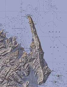
The Adare Peninsula (71°40′S 170°30′E / 71.667°S 170.500°ECoordinates: 71°40′S 170°30′E / 71.667°S 170.500°E), sometimes called the Cape Adare Peninsula, is a high ice-covered peninsula, 40 miles (60 km) long, in the northeast part of Victoria Land, extending south from Cape Adare to Cape Roget. The peninsula is considered the southernmost point of the Borchgrevink Coast, named for Carsten Borchgrevink (1864-1934). Named by the New Zealand Antarctic Place-Names Committeefor nearby Cape Adare.
The Adare Peninsula consists of overlapping shield volcanoes that have been potassium–argon dated 6 to 13 million years old. Potassium–argon dates of 2.27 million years and perhaps 1.14 million years have also been obtained.[1]
References
- ↑ "Adare Peninsula". Global Volcanism Program. Smithsonian Institution. Retrieved 14 September 2016.
![]()