Adams Island, New Zealand
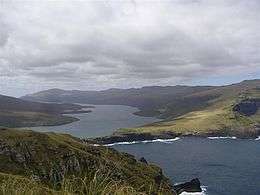 Adams Island, to the right of Carnley Harbour | |
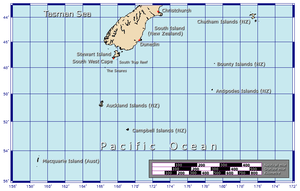 Position relative to New Zealand and other outlying islands | |
| Geography | |
|---|---|
| Coordinates | 50°52′59.99″S 166°04′59.99″E / 50.8833306°S 166.0833306°E |
| Archipelago | Auckland Islands |
| Area | 100 km2 (39 sq mi) |
| Highest elevation | 705 m (2,313 ft) |
| Highest point | Mount Dick[1] |
| Administration | |
|
New Zealand | |
| Demographics | |
| Population | 0 |
Adams Island is the second largest island of New Zealand's Auckland Islands archipelago.
Geography
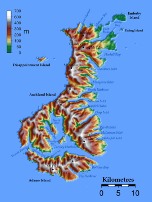
The southern end of Auckland Island broadens to a width of 26 km (16 mi) where a narrow channel, known as Carnley Harbour or the Adams Straits, separates it from the roughly triangular Adams Island (area approximately 100 km2 or 39 sq mi), which is even more mountainous, reaching a height of 705 m (2,313 ft) at Mount Dick.[1] The channel is the remnant of the crater of an extinct volcano, with Adams Island, and the southern part of Auckland Island forming the crater rim.
Two large indentations, Bolton's Bay and Fly Harbour, are the most prominent features of the island's south coast, both in the south east.
Important Bird Area
The island is part of the Auckland Island group Important Bird Area (IBA), identified as such by BirdLife International because of the significance of the group as a breeding site for several species of seabirds as well as the endemic Auckland shag, Auckland teal, Auckland rail and Auckland snipe.[2]
See also
References
- 1 2 70south site Archived 27 August 2008 at the Wayback Machine.
- ↑ BirdLife International. (2012). Important Bird Areas factsheet: Auckland Islands. Downloaded from http://www.birdlife.org on 23 January 2012.
External links
Coordinates: 50°52′59.99″S 166°04′59.99″E / 50.8833306°S 166.0833306°E