Achaphubuil
Achaphubuil
| |
|---|---|
 | |
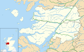 Achaphubuil Achaphubuil shown within the Lochaber area | |
| OS grid reference | NN085760 |
| Council area | |
| Country | Scotland |
| Sovereign state | United Kingdom |
| Postcode district | PH33 7 |
| Police | Scottish |
| Fire | Scottish |
| Ambulance | Scottish |
| EU Parliament | Scotland |
| UK Parliament | |
| Scottish Parliament | |
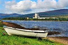
Achaphubuil (Scottish Gaelic: Achadh a' Phùbaill- the field of the tent or pavilion) is a small settlement to the north of Ardgour in Lochaber,[1] in the Highlands of Scotland. Achaphubuil lies to the south of The Narrows, which link Loch Linnhe to Loch Eil. The village of Corpach is on the opposite shore, with Fort William across Loch Linnhe to the north-east.
Achaphubuil is spread out along the A861 road, which runs along the shore of the loch.[2][3]
There was a foot ferry between Achaphubuil and Corpach across Loch Eil.
Achaphubuil had a small primary school, which closed in 2010.
References
| Wikimedia Commons has media related to Achaphubuil. |
This article is issued from
Wikipedia.
The text is licensed under Creative Commons - Attribution - Sharealike.
Additional terms may apply for the media files.