Aceh Besar Regency
| Aceh Besar Regency Kabupaten Aceh Besar اچيه بسر | ||
|---|---|---|
| Regency | ||
 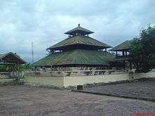 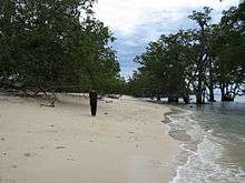 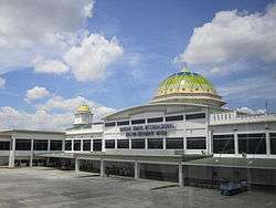 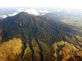 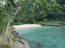 From top left : Cut Nyak Dhien house, Indrapuri Old Mosque, Lhok Me Beach, Sultan Iskandar Muda Airport, Seulawah Agam, Lhok Mata Ie beach | ||
| ||
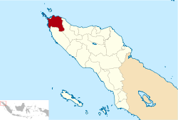 Location within Aceh | ||
| Coordinates: 5°22′N 95°32′E / 5.367°N 95.533°ECoordinates: 5°22′N 95°32′E / 5.367°N 95.533°E | ||
| Country | Indonesia | |
| Region | Sumatra | |
| Province | Aceh | |
| Regency | 1956 | |
| Capital | Jantho | |
| Government | ||
| • Regent | Mawardi Ali | |
| • Vice Regent | Husaini A. Wahab | |
| Area | ||
| • Total | 2,969.00 km2 (1,146.34 sq mi) | |
| Population (2014) | ||
| • Total | 369,972 | |
| • Density | 120/km2 (320/sq mi) | |
| Time zone | UTC+7 (IWST) | |
| Area code | (+62) 651 | |
| Website |
acehbesarkab | |


Aceh Besar Regency is a regency (Indonesian: kabupaten) of Aceh Special Territory (daerah istimewa), Indonesia. The Regency covers an area of 2,969 square kilometres and according to the 2010 census had a population of 351,418; the latest official estimate (for January 2014) is 369,972. The Regency is located at the northwest tip of Sumatra island and surrounds the provincial capital of Banda Aceh. The seat of the Regency government is Jantho.[1] The regency is divided into 23 districts (Indonesian: kecamatan) with 618 villages (Indonesian: gampong).
Economy
Aceh Besar Regency produces cloves, nutmeg and palm oil and rice, and also small quantities of maize, cassava, sweet potatoes and beans.[2]
Landmarks
Museums
Aceh Besar Regency contains several museums. The Museum dan Rumoh Aceh is the State Museum, located in Banda Aceh. The museum's main building is built in the style of a traditional Acehnese house. It was installed by Dutch Governor Van Swart in 1915.[3] Museum Ali Hasymi contains the personal collection of Ali Hasymi, a former governor of Aceh and artist and include books by the scholars of Acehnese past, ancient ceramics, the typical weapons of Aceh, souvenirs from all over the world, etc. Museum Cut Nyak Dhien was originally the home of the heroine Cut Nyak Dhien. The ancient Abee Tanoh Library, located at the foot of Mount Seulawa contains some important manuscripts.
Places of worship
Indra Puri Old Mosque is located about 20 km south of Medan. Indra Puri was a Hindu kingdom and it was a place of worship before Islam arrived. Later, Sultan Iskandar Muda introduced Islam to the public. After the people embraced Islam, the previous temple was converted into a mosque.[4] The mosque site covers an area of 33,875 m², and is located approximately 150 meters from the edge of Krueng Aceh River.
Fortress and tombs
Indra Patra Fortress is situated 19 km from Banda Aceh at Krueng Raya. According to history it was built under the Indra Puri Hindu kingdom, although some say that the fort was built during the Sultanate of Aceh Darussalam in an effort to resist the Portuguese. The fort had a very important function at the time of Sultan Iskandar Muda.[5]
The Tomb of Admiral Malahayati is located about 32 km from the city of Banda Aceh.
Administrative divisions
The regency is divided administratively into twenty-three districts (Indonesian: kecamatan), which comprise 618 villages. The areas of the districts and their populations at the 2010 Census are listed below:[6]
| Name | Area (in km2) | Population Census 2010 | No of villages |
|---|---|---|---|
| Baitussalam | 36.52 | 16,590 | 13 |
| Blang Bintang | 52.14 | 10,723 | 25 |
| Darul Imarah | 32.97 | 46,397 | 32 |
| Darul Kamal | 16.20 | 6,766 | 14 |
| Darussalam | 77.66 | 22,633 | 29 |
| Indrapuri | 282.75 | 19,975 | 52 |
| Ingin Jaya | 99.68 | 28,064 | 55 |
| Kota Jantho | 280.02 | 8,443 | 12 |
| Krueng Barona Jaya | 8.70 | 14,096 | 12 |
| Kuta Baro | 95.88 | 23,541 | 52 |
| Kuta Cot Glie | 232.31 | 12,388 | 32 |
| Kuta Malaka | 28.72 | 5,891 | 15 |
| Lembah Seulawah | 326.53 | 10,753 | 12 |
| Leupung | 76.00 | 2.553 | 6 |
| Lho'nga | 99.05 | 14,874 | 25 |
| Lhoong | 124.92 | 9,093 | 28 |
| Mesjid Raya | 110.38 | 20,864 | 13 |
| Montasik | 125.81 | 17,732 | 53 |
| Peukan Bada | 32.00 | 15,462 | 26 |
| Pulo Aceh | 92.85 | 3,796 | 17 |
| Seulimeum | 466.94 | 21,519 | 41 |
| Simpang Tiga | 42.87 | 5,360 | 18 |
| Suka Makmur | 74.00 | 13,905 | 35 |

Rusa Island
Rusa Island in Lhoong district was shaped like Rusa (deer) before the tsunami struck the island on 26 December 2004, but now the form of the island changed and become smaller like a lamb embryo. The island is very important for marking Indonesian boundaries due to its location in the outer-most west island in Indonesia with Titik Dasar TD175 and Titik Referensi TR175 (Base Point TD175 and Reference Point TR175).[7]
Bunta Island
After the tsunami struck Bunta island, a 45 minutes sail by traditional machine boat from Ujong Pancu Village, Peukan Bada, there are no inhabitant live there anymore. Nowadays some people use the island as coconut plantation, but they live in Banda Aceh. Due to the tsunami washed out all of the living creature there, so nowadays there are no squirrel, monkey or snake in the island. The island is popularized by documentary film "Hikayat di Ujung Pesisir" and ideal for camping with no facilities at all, and modest snorkeling can be done there.[8]
References
- ↑ Discussion Paper on Enhancing Community Resilience to Natural Disasters: Lives of Children and Youth in Aceh. United Nations Publications. p. 31.
- ↑ Indonesia handbook. Dept. of Information, Republic of Indonesia. 1975. p. 91.
- ↑ "Pariwisata". Government of Aceh. Archived from the original on 12 December 2010. Retrieved December 20, 2010.
- ↑ Oey, Eric (1991). Sumatra. Periplus Editions. p. 191. ISBN 0-8442-9907-3.
- ↑ "Indra Patra". Indonesia Tourism. Archived from the original on 24 November 2010. Retrieved December 20, 2010.
- ↑ Biro Pusat Statistik, Jakarta, 2011.
- ↑ "Pulau Rusa". May 20, 2012.
- ↑ Malvyandie Haryadi (July 15, 2015). "Pulau Bunta, Aceh Besar, Bukti Eksotisme Negeri Zamrud Khatulistiwa".
Regencies and cities of Aceh | ||
|---|---|---|
Capital: Banda Aceh | ||
| Regencies |  | |
| Cities | ||
| Authority control |
|---|