Aberfeldy River
| Aberfeldy (Nambruc[1][2]) | |
| River[3] | |
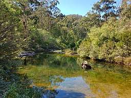 View of the Aberfeldy River from Aberfeldy Bridge at Baw Baw National Park. | |
| Country | Australia |
|---|---|
| State | Victoria |
| Regions | Victorian Alps (IBRA), West Gippsland |
| Local government area | Shire of Baw Baw |
| Part of | West Gippsland catchment |
| Source confluence | North and South Branches of the Aberfeldy River |
| - location | below Mount Selma |
| - elevation | 662 m (2,172 ft) |
| - coordinates | 37°39′16″S 146°25′48″E / 37.65444°S 146.43000°E |
| Mouth | confluence with the Thomson River |
| - location | north of Rawson |
| - elevation | 253 m (830 ft) |
| - coordinates | 37°44′39″S 146°21′41″E / 37.74417°S 146.36139°ECoordinates: 37°44′39″S 146°21′41″E / 37.74417°S 146.36139°E |
| Length | 49 km (30 mi) |
| [3][4] | |

The Aberfeldy River is a perennial river[3] of the West Gippsland catchment, located in the Alpine region of the Australian state of Victoria.
Features and location
Formed by the confluence of the North and South branches of the river, the Aberfeldy River rises in a state forestry area below Mount Selma on part of the Great Dividing Range. The river flows generally southwest then south, joined by two minor tributaries, before reaching its confluence with the Thomson River north of Rawson, in the Shire of Baw Baw. The river descends 409 metres (1,342 ft) over its 49-kilometre (30 mi) course.[4]
Etymology
In the Australian Aboriginal Brataualung language the river is named Nambruc, meaning "plenty of black opossums".[1][2]
See also
References
- 1 2 "Aberfeldy River: 9139: Traditional name: Nambruc". Vicnames. Government of Victoria. 12 May 2011. Archived from the original on 22 February 2014. Retrieved 13 February 2014.
- 1 2 "Aberfeldy River: 9139: Traditional name: Nambruc". Vicnames. Government of Victoria. 12 August 2011. Archived from the original on 22 February 2014. Retrieved 13 February 2014.
- 1 2 3 "Aberfeldy River: 9139". Vicnames. Government of Victoria. 2 May 1966. Archived from the original on 22 February 2014. Retrieved 13 February 2014.
- 1 2 "Map of Aberfeldy River, VIC". Bonzle Digital Atlas of Australia. Retrieved 14 February 2014.
External links
- "West Gippsland Regional Catchment Strategy (2013 - 2019)" (PDF – 4MB). West Gippsland Catchment Management Authority. 2012. ISBN 978-0-9805562-8-5.
- "Latrobe Catchment Ecosystem" (PDF). West Gippsland Catchment Management Authority. 2012. Archived from the original (PDF) on 6 April 2011.
Rivers of the West Gippsland catchment, Victoria, Australia | |
|---|---|
|
This article is issued from
Wikipedia.
The text is licensed under Creative Commons - Attribution - Sharealike.
Additional terms may apply for the media files.