Aberdeen High School (Washington)
| Aberdeen High School | |
|---|---|
| Address | |
|
410 North G Street Aberdeen, Washington 98520 United States | |
| Information | |
| Type | Public |
| Established | 1908 |
| Principal | Sherri Northington |
| Faculty | 52 |
| Enrollment | 868 (May 2013) |
| Color(s) | Blue and Gold |
| Mascot | Bobcat |
| Website | http://www.asd5.org/Domain/40 |
J. M. Weatherwax High School, commonly Aberdeen High School, is a public high school located in Aberdeen, Washington, and is part of the Aberdeen School District. The high school mascot is the Bobcat. The school teaches grades from 9 to 12.
Demographics
As of the 2012-2013 school year, there were 868-926 students enrolled, 52.3% of which were male, and 47.7% female. 65.2% of the students were White, 22.6% Hispanic/Latino, 3.8% American Indian, 6.2% Asian-American, and 0.8% African American. There were 52 classroom teachers, for an average of 16.7 students per teacher in May 2013.[1]
Fire
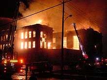
On Saturday, 5 January 2002, the Weatherwax building of Aberdeen High School, one of Aberdeen's most historical buildings (built in 1909), burned to the ground[2] just after midnight. The Weatherwax building housed the school library, counseling office, and many classrooms. Students were spread out over the remaining campus until the new school was built.
The grand opening of the new building and official dedication ceremony was held on August 25, 2007. The new high school building is now open for the school year, starting 4 September 2007. Parts of the masonry from the original Weatherwax building have been incorporated into the walls of the current one, including an old concrete sign reading "J. M. Weatherwax" inside the main entrance.
Sports
The following sports are offered:
Boys' sports:
- Football
- Baseball
- Basketball
- Soccer
- Wrestling
- Fight Club
- Tennis
- Cross Country
- Track and Field
- Golf
- Swimming
Girls' sports:
- Basketball
- Fastpitch
- Volleyball
- Soccer
- Golf
- Swimming
- Track and Field
- Cross Country
- Wrestling
- Tennis
- Bowling
Notable alumni
- Mark Bruener - Former NFL football player
- Kurt Cobain - Nirvana lead singer and guitarist from grunge band Nirvana
- Dale Crover - Melvins drummer
- Bryan Danielson - Professional wrestler, known as Daniel Bryan in WWE
- Chris Freeman - Pansy Division bass guitarist
- Mel Ingram - Former MLB player (Pittsburgh Pirates)
- Krist Novoselic - Nirvana bass guitarist from Nirvana, Sweet 75, Eyes Adrift
- Douglas D. Osheroff 1996 - Nobel Prize in Physics for the discovery of superfluidity in the isotope helium-3
- Wesley Carl Uhlman - Mayor of Seattle, 1969-1978; youngest mayor of Seattle
Activities
- Renaissance Action Team
- Associated Student Body (ASB)
- SkillsUSA
- FFA
- FBLA
- National Honor Society
- Cheerleading
- Jazz Band
- Choir
- Goldenaires (Jazz Choir)
- Orchestra
- Symphonic Band
- Wind Ensemble
- Marching Band
- ASL (American Sign Language)
- Chess Club
- Club Mud (3D art club)
- The A-Team (Dance club)
And much more
References
- ↑ OSPI school report card 2012-13. Retrieved 2013-11-17
- ↑ Kamb, Lewis (7 January 2002). "Aberdeen history burns". Seattle Post-Intelligencer. Archived from the original on 2008-01-29. Retrieved 2007-03-01.
External links
Coordinates: 46°58′45″N 123°49′16″W / 46.9792593°N 123.8209998°W