Abd al Kuri
| Disputed island | |
|---|---|
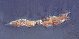 Photograph by NASA astronauts | |
| Geography | |
 | |
| Coordinates | 12°11′8.9″N 52°14′18″E / 12.185806°N 52.23833°ECoordinates: 12°11′8.9″N 52°14′18″E / 12.185806°N 52.23833°E |
| Archipelago | Socotra Archipelago[1] |
| Area | 133 square km |
| Length | 36km |
| Width | 5 |
| Highest point |
|
| Administered by | |
| Yemen | |
| Governorate | Socotra Governorate[3] |
| Capital city | Kilmia |
| Claimed by | |
| Somalia | |
| Demographics | |
| Population | 450[1] |
| Density | 3.38/km² |
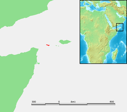
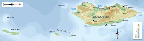
Abd al Kuri (Arabic: عبد الكوري) is a rocky island in the Guardafui Channel.[4] As a part of the Socotra Archipelago[2] of the Socotra Governorate of Yemen,[3], it lies about 65 miles (105 km) southwest of the island of Socotra.[2] It is geographically closer to Somalia.[2] It consists of granite and diorite covered by limestone.[5] There is a dispute between Yemen and Somalia's government over the island's sovereignty.[6]
Geography
Much of Abd al Kuri is semi-desert with little vegetation.[2] Two ranges of hills separated near the centre occupy the entire length of the island.[7] The northern coast consists mostly of a sandy beach with a few rocky points, while the southern coast consists of steep cliffs.[7][8] Its highest point, Mount Ṣāliḥ, reaches an altitude of over 700 metres (2,300 feet). Most of its inhabitants subsist on fishing.[2] Kilmia is the main village.[9]
Abd al Kuri has a number of endemic plant species[2] and an endemic bird, the Abd al-Kuri sparrow with estimated population of fewer than 1,000.[10][11][12]
History
On 1 July 2006, the Somali seafaring vessel Mariam IV sank off the coast of Abd al Kuri. 16 of the 19 crew members survived, and complications followed when the citizens of Kilmia would not allow the use of their own radio. Rescue by a German helicopter came a week later, but the chief officer was mistakenly left behind. Due to difficulties with wind, transportation, and communication, the officer was not returned to mainland Yemen until September. He described the island as "A hellish place, where time stands still, and one can feel completely alone in the world."
Gallery
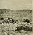 Native dwellings (1903)
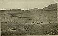 View of the 'Strath' and Native Dwellings, Abd-el-Kuri, 1898
Map
References
- 1 2 Socotra Governance & Biodiversity Project - "Welcome to Socotra" 10-06-2011.
- 1 2 3 4 5 6 7 "ʿAbd al-Kūrī." Encyclopædia Britannica. Encyclopædia Britannica Online. Encyclopædia Britannica, 2011. Web. 6 October 2011.
- 1 2 GeoNames National Geospatial-Intelligence Agency. Retrieved 3 December 2011.
- ↑ Steele, John. Ocean Currents: A Derivative of the Encyclopedia of Ocean Sciences. p. 160.
- ↑ Schürmann (1974) pp. 24.
- ↑ "For First Time in History, Somalia Claims Socotra as Its Own". Yemen Post. 27 October 2010. Retrieved 28 May 2018.
- 1 2 Nautical magazine (1878) pp. 809.
- ↑ National Geospatial-Intelligence Agency (2007) pp. 180.
- ↑ http://wikimapia.org/6364535/Abd-al-Kuri-Island
- ↑ http://www.birdlife.org/datazone/speciesfactsheet.php?id=32537
- ↑ 2010. "Passer hemileucus" In: IUCN 2011. IUCN Red List of Threatened Species. Version 2011.1. Archived 23 September 2011 at the Wayback Machine. Downloaded on 6 October 2011.
- ↑ Redman; Fanshawe; Stevenson (2009) pp. 412.
Bibliography
- National Geospatial-Intelligence Agency (2007). Sailing Directions - Enroute. ProStar Publications.
- Nautical magazine, Volume 47. London: Brown, Son, and Ferguson. 1878.
- Redman, Nigel; Fanshawe, John; Stevenson, Terry (2009). Birds of the Horn of Africa: Ethiopia, Eritrea, Djibouti, Somalia, Socotra. A&C Black.
- Schürmann, H. M. E. (1974). The Pre-cambrian in North Africa. Brill Archive.
External links

| Arabian Sea | |
|---|---|
| Guardafui Channel | |
| Red Sea |
|
1Socotra island became under the control of United Arab Emirates since April 30, 2018[1][2]
| |
- ↑ "Yemen officials say Emiratis boost forces on Socotra island". The Washington Post.
- ↑ "SOCOTRA: HOW A STRATEGIC ISLAND BECAME PART OF A GULF POWER STRUGGLE". Jerusalem Post.