ACE High
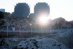
ACE High was an abbreviation for Allied Command Europe; a fixed service NATO radiocommunication system which dates back to 1956. The frequency supportability and frequency assignments were profited in accordance with the NATO Joint Civil/Military Frequency Agreement (NJFA). The system was decommissioned in the late 1980s. The system was designed to be an UHF troposcatter radio system, which was meant to provide long-range communication service in the form of telephone and telegraph in the NATO chain of command. These services combined produced over 200 channels and equipment was in place to multiplex them to contain up to 12 different calls each. There were 82 terrestrial stations, located in 9 different NATO countries.
The transmitters broadcast at 832.56 to 959.28 MHz and some were able to produce a transmitting power of about 10 kilowatts.[1]
ACE High sites
The ACE High network included the following major sites and terminals, but also connected LOS (line of sight) microwave links to other networks reaching C2 centres not listed here.[2]
- Norway - AFNORTH
- (NC- Senja)
- NSEZ - Senja
- Position 69°19'44.06"N 17°29'49.52"E
- Station Power Plant Category: unknown
- Station Transmitter Equipment:1S + 1R (Scatter Line + Radio Line)
- (nca - Höggumpen)
- NHGZ - Höggumpen
- Position 69°04'41.27"N 18°00'16.53"E 502 m AMSL
- Station Power Plant Category: unknown
- Station Transmitter Equipment:1R (Radio Line)
- (ND- Bodö)
- NKLZ - Bodoe
- Position 67°10'23.34"N 15°01'24.42"E 801 m AMSL
- Station Power Plant Category:I
- Station Transmitter Equipment:2S + 1R(Scatter Line + Radio Line)
- (nda - Bodoe Tail - Kletkov)
- NVAZ - Kletkov
- Position:no information
- Station Power Plant Category:unknown
- Station Transmitter Equipment:1R (Radio Line)
- (NE - Mosjöen)
- NMOZ - Mosjoen
- Position 65°52'41.93"N 13°18'11.54"E 627 m AMSL
- Station Power Plant Category:I
- Station Transmitter Equipment:2S (Scatter Line)
- (NF - Trondheim)
- NSBZ - Trondheim
- Position 63°18′41.01″N 10°56′17.75"E 677 m AMSL
- Station Power Plant Category:I
- Station Transmitter Equipment:2S + 1R (Scatter + Radio Line)
- (nfa - Trondheim Tail - Graakallen)
- Position 63°25'15.27"N 10°15'06.65"E 543 m AMSL
- Station Power Plant Category:unknown
- Station Transmitter Equipment:1R (Radio Line)
- (NG - Oslo AAA)
- NSOZ - Oslo
- Position 60°03'34.24"N 11°16'09.06"E 246 m AMSL
- Station Power Plant Category:I
- Station Transmitter Equipment:2S + 1R (Scatter Line + Radio Line)
- (Oslo YYY - Svartas)
- NVAZ - Svartas
- Position:no information
- Station Power Plant Category:unknown
- Station Transmitter Equipment:3R (Radio Line)
- (nga - Oslo Tail 01 - Kolsaas)
- NKOZ - Kolsaas
- Position:no information
- Station Power Plant Category:unknown
- Station Transmitter Equipment:1R (Radio Line)
- (ngb - Oslo Tail 02 - Maakeroy)
- NVEZ - Maakeroy
- Position 59°09'22.44"N 10°26'19.01"E 14 m AMSL
- Station Power Plant Category:unknown
- Station Transmitter Equipment:1R (Radio Line)
- (NH - Kristiansand - Stormyrheia)
- NSMZ - Kristiansand
- Position 58°27'19.14"N 08°27'43.45"E 326 m AMSL
- Station Power Plant Category:I
- Station Transmitter Equipment:3S (Scatter Line)
- (NJ - Sola - Lysenut)
- NLYZ - Sola
- Position 59°31'40.46"N 05°54'12.25"E 792 m AMSL
- Station Power Plant Category:I
- Station Transmitter Equipment:2S (Scatter Line)
- Denmark - AFNORTH
- (DA - Karup - Torphøj)
- DTOZ - Kollemorten
- Position 55°52'28.98"N 09°21'00.95"E 135 m AMSL
- Station Power Plant Category:I
- Station Transmitter Equipment:2S + 1R (Scatter Line + Radio Line)
- (daa - Karup Tail - Lundbakke)
- DLUZ - Lundebakke
- Position 56°13'49.03"N 09°09'48.63"E 68 m AMSL
- Station Power Plant Category:1b
- Station Transmitter Equipment:1R (Radio Line)
- United Kingdom
- (EAA - Faroes - Sandfelli 2)
- (EA - Shetlands - Mossy Hill) > UMSZ - Mossy Hill > 59°57'17.15"N 01°18'11.60"W 227 m AMSL
- (eab - Shetlands Tail Relay - Collofirth Hill) > UCOZ - Collafirth Hill > 60°32'00.75"N 01°23'28.30"W 239 m AMSL
- (eac - Shetlands Tail - Saxa Vord) USVZ - Saxa Vord 60°49'37.20"N 00°50'22.59"W 276 m AMSL
- (EB - Aberdeen - Mormond Hill) > UMOZ - Mormond Hill 57°36'11.19"N 02°01'51.86"W 227 m AMSL
- (eba - Aberdeen Tail - Long Haven Hill) > UBUZ - Long Haven Hill 57°27'31.94"N 1°48'46.07"W 95 m AMSL
- (EC - Boulmer - Brizlee Wood) > UBOZ - Brizlee Wood 55°25'05.28"N 1°46'04.26"W 250 m AMSL
- (ED - Binbrook - Stenigot) > UBIZ - Stenigot 53°19'36.08"N 00°06'57.44"E 153 m AMSL
- (EE - London - Coldblow Lane) > UMAZ - Coldblow Lane 51°17'44.95"N 00°36'51.52"E 194 m AMSL
- (eeb - London Tail Relay - Woldingham - RAF Botley Hill Farm)
- (eea - London tail - Hillingdon)
- RAF Uxbridge – local terminus
- France
- (FAN - Paris - Mont Florentin) FFLZ - Paris North 49°20'27.59"N 02°03'06.79"E 222 m AMSL
- FTAZ - Taverny 49°02'02.88"N 02°13'45.85"E 178 m AMSL
- (fac - Paris Tail (2)- Sant Germain) 48°54'44.67"N 02°01'25.44"E 71 m AMSL
- (fae - Paris Tail (2) - Extension (SHAPE) 48°50'34'19"N 02°06'14.30"E 178 m AMSL
- (fa - Relais Paris - Emeville) FEMZ - Emeville 49°18'01.83"N 03°00'41.00"E 247 m AMSL
- (faa - Paris Tail (1) - Laffaux) 49°27'15.05"N 03°24'57.39"E 143 m AMSL
- (fad - Relay Paris - Rozoy Bellevalle) FRBZ - Rozoy Bellevalle 48°55'56.05"N 03°28'24.62"E 219 m AMSL
- (FAS - Paris - Mont Aout) FAOZ - Paris South 48°46'14.78"N 03°53'25.33"E 216 m AMSL
- (FA - Trier - Rohrbach) FROZ - Rohrbach 49°03'18.47"N 07°14'40.74"E 376 m AMSL
- (fay - Trier Tail - Kindsbach) ABHZ - Kindsbach 49°23'48.11"N 07°35'38.32"E 458 m AMSL
- (FC - Lyon - Pierre sur Haute) FLYZ - Lyon 45°39'11.52"N 03°48'33.07"E 1632 m AMSL
- (FD - Nice - Signal de la Chens) FNIZ - Nice 43°44'53.67"N 06°39'44.85"E 1703 m AMSL
- Netherlands
- HBRZ - Brunssum 50°56'19.11"N 05°58'35.60"E 95 m AMSL
- HMAZ - Maastricht 50°50'25.05"N 05°39'33.78"E 82 m AMSL
- Belgium
- BADZ - Adinkerke
- BCAZ - Casteau (SHAPE) Supreme Headquarters Allied Powers Europe - Central command of NATO military forces 50°30'05.56"N 03°58'15.69"E 87 m AMSL
- BCHZ - Chievres
- BFRZ - Baraque de Fraiture 50°15'07.94"N 05°43'56.13"E 654 m AMSL
- Italy
- IDGZ - Dosso dei Galli 45°51'13.66"N 10°22'32.28"E 2174 m AMSL
- IVTZ - Verona Tail ( im West Star Bunker ) 45°33'17.89"N 10°45'46.83"E 334 m AMSL
- (IA - Livorno - Monte Giogo) IMXZ - Livorno 44°19'17.38"N 10°07'30.94"E 1496 m AMSL
- (IAZ - Cavriana - Monte Bosco Sucro) IMBZ - Cavriana 45°21'00.79"N 10°37'01.46"E 189 m AMSL
- (iaa - Verona Torre 4) 45°27'11.35"N 11°00'30.55"E 164 m AMSL
- (IAY - Lame - Cavanella) ICEZ - Lame Concordia 45°44'55.99"N 12°52'08.75"E 7 m AMSL
- (iax - Aviano) IAVZ - Aviano 46°01'23.02"N 12°35'34.19"E 99 m AMSL
- (IB - Rome - Tolfa) ITLZ - Rome 42°09'01.76"N 11°54'32.73"E 621 m AMSL
- (iba - Rome Tail - Monte Cavo) IMCZ - Monte Cavo 41°45'04.86"N 12°42'31.03"E 930 m AMSL
- (IC - Neaples - Ischia - Punta Fetto) IICZ - Neaples 40°35'50.88"N 13°54'08.54"E 639 m AMSL
- (ica - Neaples Tail - Monte Pecorara) IPEZ - Monte Petrino 41°13'24.29"N 13°57'57.75"E 335 m AMSL
- (icy - Monte Vergine) IMNZ - Monte Nardello 40°56'33.27"N 14°43'07.28"E 1516 m AMSL
- (icz - Monte Vulture) IVUZ - Monte Vulture 40°57'03.12"N 15°38'10.75"E 1301 m AMSL
- (icv - Monte Iacontenente)
- (icf - Pietra Ficcata) IPFZ - Pietra Ficcata 40°34'04.90"N 16°19'21.31"E 586 m AMSL
- (icw - Martina Franca) IAMZ - Martina Franca
- (ID - Catanzaro - Monte Mancuso) IMMZ - Catanzaro 39°01'09.13"N 16°13'32.02"E 1319 m AMSL
- (IDA - Monte Lauro - Cozzo tre Grotte) ICCZ - Monte Lauro 37°06'52.13"N 14°51'18.96"E 944 m AMSL
- Malta
- (idb - Malta - Gharghur) IDBZ - Malta - Gharghur
- Greece
- (GA - Kefallina) > GKFZ - Kefallonia 38°10'11.18"N 20°37'08'53"E 1001 m AMSL
- (GB - Athens - Pendelikon) > GPKZ - Athens 38°04'50.46"N 23°52'58.14"E 1038 m AMSL
- (GBZ - Crete - Ziros) > GZIZ - Ziros 35°03'53.52"N 26°09'14.24"E 786 m AMSL
- (GBY - Larissa - Phillon) > GPIZ - Phillon 39°25'22.75N 23°03'11.54"E 1513 m AMSL
- (GBW - Vitsi) > GVIZ - Vitzi 40°38'43.34"N 21°23'11.07"E 2009 m AMSL
- (GBV - Ismaros) > GISZ - Ismaros 40°53'34.67"N 25°32'56.06"E 612 m AMSL
- Turkey
- (TA - Izmir - Bespinar Tepes) > TBPZ - Izmir - Bespinar Tepes 38°18'48.72"N 27°01'29.89"E 964 m AMSL
- (taa - Izmir Tail) > TKYZ - Izmir Tail
- (TB - Eskisehir) > TKUZ - Eskishir - Kutahya Dagi 39°25'03.25"N 29°51'19.07"E 1820 m AMSL
- (tba - Eskirsehir Tail) > TESZ - Eskirsehir Tail
- (TC - Ankara) > TEDZ - Ankara - Elan Dagi 39°48'20.59"N 32°59'32.27"E 1856 m AMSL
- (TCK - Merzifon) > TKJZ - Merzifon
- (TCW - Persembe) > TPEZ - Persembe
- (TCV - Pazar) > TPAZ - Pazar
- (TD - Siwas - Pinarbasi) > TPIZ - Pinarbasi 38°40'38.09"N 36°24'10.59"E 2285 m AMSL
- (TG - Adana) > TDDZ - Davudi Dağı 36°49'39.37"N 35°38'18.66"E 515 m AMSL
- (tga - Adana Tail) > TDAZ - Adana Tail
- (TE - Dyarbakir - Karaka Dagi) > TDIZ > Dyarbakir - Karaka Dagi
- (tea - Dyarbakir Tail) > TDEZ - Dyarbakir Tail
- Bloatli, Turkey
- Cyprus
- (TCZ - Cap Greco) > JCGZ -Cavo Greko 36°58'00.85"N 34°04'11.41"E 62 m AMSL
- Germany
- ABHZ - Kindsbach 49°23'51.24"N 07°35'41.17"E 458 m ü. NN
- (AA - Emden - Aurich) AEMZ - Aurich 53°30'32.04"N 07°26'34.83"E 10 m ü. NN
- (AB - Moenchengladbach - Roetgen) ALAZ -Lammersdorf 50°39'57.59"N 06°17'14.58"E 593 m ü. NN
- (abb - Moenchengladbach Tail (1) - Hehn) AHEZ - Hehn 51°10'51.44"N 06°23'37.77"E 81 m ü. NN
- (aba - Moenchengladbach Tail (2) - Millen) 50°45'57.87"N 05°33'47.26"E 151 m ü. NN
- (abc - Uedem) AUEZ - Uedem 51°39'39.08"N 06°16'58.97"E 47 m ü. NN
- AFEZ - Feldberg 47°52'23.09"N 08°00'59.73"E 1458 m ü. NN
- Denmark
- (DAA - Karup Tail - Lundbakke) DLUZ - Karup 56°13'49.03"N 09°09'48.63"E 68 m AMSL
- (DA - Karup - Torphoej) DTOZ - Kollemorten 55°52'28.98"N 09°21'00.95"E 135 m AMSL
See also
- Radio propagation
- Tropospheric scatter
- Microwave
- White Alice Communications System - Cold war era Alaskan tropospheric communications link
- List of White Alice Communications System sites
- List of DEW Line Sites
- Distant Early Warning Line
References
- ↑ ACE HIGH. SCALE OF THE SYSTEM, Andy Emmerson, 2003 // Subterranea Britannica: "The emission mode was F9 (frequency modulation, miscellaneous), and output powers typically 10kW to 50kW."
- ↑ http://rammstein.dfmk.hu/~s200/tropo.html