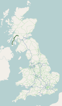
A83 road
| |
|---|---|
 | |
| Route information | |
| Length | 98.3 mi[1] (158.2 km) |
| Major junctions | |
| Northeast end | Tarbet (NN319044) |
|
| |
| Southwest end | Campbeltown (NR720204) |
| Location | |
| Primary destinations | Glasgow, Inveraray, Lochgilphead, Campbeltown |
| Road network | |

The A83 is a major road in the south of Argyll and Bute, Scottish Highlands, running from Tarbet, on the western shore of Loch Lomond, where it splits from the A82, to Campbeltown at the southern end of the Kintyre peninsula.
Route

From Tarbet the A83 runs west across the watershed between Loch Lomond and Loch Long to Arrochar near the head of Loch Long. It then goes round the head of the loch, and along the western shore for a short distance, before turning NW up Glen Croe to the Rest & be thankful viewpoint picnic area in Cowal (56°13′36″N 4°51′25″W / 56.22667°N 4.85694°W), at the pass through the Arrochar Alps from the shore of Loch Long to that of Loch Fyne. It was near this spot that an RAF Tornado crashed on 2 July 2009.[2]
REST & BE THANKFUL are the words inscribed on a stone near the junction of the A83 and the B828, placed there by soldiers who built the original military road in 1753, now referred to as the Drovers' road. The original stone fell into ruin and was replaced by a commemorative stone at the same site.
The section is so named as the climb out of Glen Croe is so long and steep at the end that it was traditional for travellers to rest at the top, and be thankful for having reached the highest point. The current road no longer keeps to the floor of Glen Croe but steadily climbs across the southern slopes of The Cobbler, on the north side of the Glen, to the highest point of the pass. The westward descent to Loch Fyne is through Glen Kinglas. At Cairndow the A815, the main road down the Cowal peninsula , south to Dunoon and finally Toward at the A815 roads end, both on the Firth of Clyde.
On reaching the shore of Loch Fyne, the main road follows the eastern shore of the loch northwards to its head and then goes south west along the western shore through Inveraray and then on to Lochgilphead and Ardrishaig, where it crosses the entrance to the Crinan Canal.
From Ardrishaig the road continues south to Tarbert, where it crosses over to the western shore of the Kintyre peninsula. In the final section it passes through the villages of Whitehouse, Clachan, Tayinloan, Muasdale and Bellochantuy before finally crossing back to the east of the peninsula, on the Firth of Clyde coast, as it reaches Campbeltown.
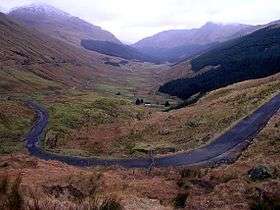 Glen Croe viewed from Rest and be thankful viewpoint
_2006-11-18.JPG) Glen Croe, 18 November 2006
Glen Croe, 18 November 2006
Rest and be Thankful
The stretch south of the Rest and be thankful junction has been closed on a number of occasions due to landslides, causing significant disruption to local traffic. The road was closed here due to a 400 tonne landslide on 28 October 2007.[3] The road was partially reopened on Monday 10 November.[4] A 1,070 tonne landslide closed the road around noon on 8 September 2009.[5] The road reopened at 15.00 on 10 September 2009.[6] A landslip on 1 December 2011 closed the road for 24 hours, another closed the road from 22 February 2012, and an even more substantial landslip in August 2012 resulted in further major delays and closures. On the 3 October 2013, the road was reopened at 17.30, had been closed between the A815 and the B828. Contractor Bear Scotland said that from 21:00 they would continue to work on some sections of the A83, so drivers may experience slight delays during the night. [7][8] [9][10] On 30 December 2015, Storm Frank caused a 200 tonne landslide here; 2 cars were caught up in the debris but no one was harmed. The road reopened the following afternoon. [11][12]
References
- ↑ "Driving directions to Longrow S/A83". Google. Retrieved 23 September 2013.
- ↑ News.bbc.co.uk Two killed in RAF Tornado crash
- ↑ "'Flatout' efforts to reopen A83" - BBC News
- ↑ Blog.islayinfo.com, Islay Weblog - A83
- ↑ "Landslip on Rest and Be Thankful" - BBC News
- ↑ "Landslide road cleared to reopen" - BBC News
- ↑ BBC News 1 December 2011
- ↑ "Landslip closes A83 Rest and Be Thankful in Argyll" - BBC News
- ↑ "A83 could reopen today as work resumes to clear Rest and Be Thankful landslide" - The Scotsman
- ↑ "A83 at Rest and be Thankful reopens following landslip" - BBC News
- ↑ "Argyll News: A83 now closed with landslide at Rest & Be Thankful". For Argyll. 2015-12-30. Retrieved 2016-12-14.
- ↑ Campbell, Rita (2015-12-30). "Storm Frank: Cars caught up in Rest and Be Thankful landslide". Press and Journal. Retrieved 2016-12-14.
External links
- 2007 Rest and Be Thankful Landslide, British Geological Survey
- 2009 Rest and Be Thankful Landslide, British Geological Survey