A1 (Bosnia and Herzegovina)
| |
|---|---|
| Autoput A1 | |
.svg.png) | |
| Route information | |
|
Part of | |
| Length | 93.5 km (58.1 mi) |
| Major junctions | |
| From | Tarčin |
| To | Zenica |
| Location | |
| Regions: | Sarajevo Canton, Zenica-Doboj Canton |
| Highway system | |
| Transport in Bosnia and Herzegovina | |

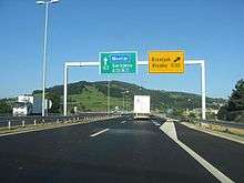


The A1 motorway (Bosnian: Autoput A1) is a motorway in Bosnia and Herzegovina that is part of the Corridor Vc and, together with two Croatian motorways (A10 and A5) and the Hungarian M6, will provide a modern and fast road connection from Budapest to Ploče, an important seaport on the Adriatic Sea. The motorway will connect the capital Sarajevo with other large cities (such as Mostar and Zenica). It will also be the main link to Bosnia and Herzegovina from the Adriatic Sea and Central Europe.
Sections
Length of the Corridor Vc highway, from the North to the South divided by sections:
- Section 1: The Sava Svilaja River (connection Corridor X) - Doboj (South)
- 64 km
- Section 2: Doboj (South) - Sarajevo South (Tarčin)
- 150 km
- Section 3: Sarajevo South (Tarčin) - Mostar (North)
- 58 km
- Section 4: Mostar (North) - Republic of Croatia Border
- 68 km
- Total: 340 km
- 68 km
By 2013, the completed section stretches from Sarajevo to Kakanj, while the sections Kakanj-Zenica, Josanica-Tarcin, Bijaca-Pocitelj and Svilaj-Odzak are currently under construction. By April 2013 53 km is completed while 64 km is under construction.[1]
On 20 June 2013, the 5 km section between Bijača and Kravice was opened.[2] A new border crossing with Croatia opened on June 28.[3]
The most complicated section of the road to build will be the Sarajevo-Mostar stretch. It will need viaducts and tunnels to cross the Dinaric Alps.
In Bosnia and Herzegovina the E73/A1 passes near the following cities:
| Odžak | Modriča | Doboj | ||
| Tešanj | Maglaj | Zavidovići | ||
| Žepče | Zenica | Kakanj | ||
| Visoko | Sarajevo | Konjic | ||
| Jablanica | Mostar | Čapljina |
Significance
In Bosnia and Herzegovina, the Corridor Vc highway is the most important road project. Construction on the road has already begun. The intensified beginning of the construction will be a key starter of economic and social activities, and will enable Bosnia and Herzegovina to be connected to main European traffic network, as well as the European economic and social structure.
Construction of the highway will provide a motorway connection to neighboring countries and regions. It will improve transportation and improve the quality of life in the areas where the road will pass through. It will improve the economy.
Transport Master Plan
Japanese International Cooperation Agency (JICA) funded provision of Transport Master Plan for Bosnia and Herzegovina (March 2001), which represents the first document in afterwar period at this level in transport area, and it was used as basis for many other studies and decisions, even for provision of Planning and Study Documentation for the Highway along the Corridor Vc.
This Study provided priority transport corridors in Bosnia and Herzegovina, which were afterwards confirmed by subsequent studies, to a great extent. At the same time, this Study defined main goals in transport sector in Bosnia and Herzegovina, as well as Development Scenario by 2020. Development Scenario includes three phases:
- Phase 1 (short-term): 2000-2005 – Rehabilitation & Stabilization
- Phase 2 (medium-term): 2006-2010 – Full functionalization & Modernization
- Phase 3 (long-term): 2011-2020 – Structuring & Progress
Exit list
| km | Exit | Name | Destination | Notes | |
|---|---|---|---|---|---|
| 0.0 | Svilaj border crossing | Svilaj border crossing to Croatia. The road continues into Croatia as the A5 motorway towards Osijek. The northern terminus of the motorway. | |||
| b0.0 | 1 | Svilaj | Connection to Bosanski Brod. | ||
| 9.5 | 2 | Odžak | Connection to Odžak. | ||
| 130.3 | 13 | (Zenica-south) | Connection to Zenica | ||
| 136.2 | 14 | Lučani (Lašva) | Connection to Travnik and Vitez | ||
| 144.6 | 15 | Kakanj | Connection to Kakanj | ||
| 161.4 | 16 | Visoko | Connection to Visoko and Kiseljak | ||
| 168.6 | 17 | Podlugovi | Connection to Ilijaš | ||
| 169.8 | Podlugovi rest area | ||||
| 179.7 | Sarajevo-north toll plaza | ||||
| 180,3 | 18 | Sarajevo-north | Connection to Tuzla and Sarajevo-north | ||
| 185.1 | 19 | Butila | Connection to Sarajevo and Višegrad | ||
| 189.1 | 20 | Sarajevo-west | Connection to Sarajevo-west, Sarajevo-Ilidža, and economic zone Sarajevo-Blazuj | ||
| 193 | Sarajevo-west toll plaza | ||||
| 198.5 | 21 | Lepenica | Connection to Kiseljak | ||
| - | Lepenica rest area | ||||
| 208.0 | 22 | Tarčin | |||
| 328.8 | 31 | Zvirovići | Connection to Međugorje | ||
| - | Kravice rest area | ||||
| 337.5 | 32 | Zvirići | Connection to Ljubuški | ||
| 340 | Bijača border crossing | Bijača border crossing to Croatia. The road continues into Croatia as the A10 motorway towards Ploče The southern terminus of the motorway. | |||
1.000 mi = 1.609 km; 1.000 km = 0.621 mi
| |||||
Environmental concerns and criticism
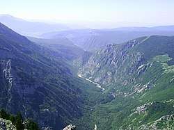
Since the beginning proposed route for the A1 highway on corridor Vc was under heavy criticism from environmentalists, groups and concerned citizens, as well as some factions in academic community and media, for its encroachment[4] on many already highly endangered natural phenomenons, habitats and to significant extent on specific way of human life in traditional communities in relationship with characteristic Dinaric karst milieu[5][6][7] and its characteristic biotope, hydrogeology and topography.[8]
This is especially emphasized in region of Herzegovina where most of Bosnia and Herzegovina's karstic topography and biodiversity is distributed. Several particular sections are of most concern: section in vicinity of Počitelj, section passing through Blagaj, and section through massif of Prenj.[9][10]
For that reason another variant of the route is proposed for every of three particular problematic sections.[8][11]
References
| Wikimedia Commons has media related to A1 (Bosnia and Herzegovina). |
- ↑ "Archived copy". Archived from the original on 2012-10-25. Retrieved 2013-04-23.
- ↑ New kilometers to EU doors: The Bijača – Kravice sub-section opened - eKapija.BA, 6/20/2013 12:26:08 PM
- ↑ Chairman of BiH Council of Ministers opens today border crossing Bijača Archived 3 March 2016 at the Wayback Machine. - SarajevoTimes, 28 June 2013
- ↑ "Environment protection and monitoring – JP Autoceste FBiH". www.jpautoceste.ba. JP Autoceste FBiH. Retrieved 24 July 2018.
- ↑ "Autoput oko Mostara: Spor Bošnjaka, Hrvata i Srba". Al Jazeera Balkans (in Bosnian). 14 August 2016. Retrieved 24 July 2018.
- ↑ "Građani protiv trase autoceste kroz Mostar". www.starmo.ba (in Bosnian). Retrieved 24 July 2018.
- ↑ "Mještani ogorčeni: Koridor Vc uništit će najplodniju zemlju, a mijenja se i izgled rijeke Bune!". nap.ba (in Bosnian). Novinska agencija Patria. 17 August 2016. Retrieved 24 July 2018.
- 1 2 Samir Huseinović (24 February 2016). "Tunel kroz „Planetu Prenj"". DW.COM (www.dw.com) (in Bosnian). Deutsche Welle. Retrieved 24 July 2018.
- ↑ "Highway from Konjic to Mostar can go through Prenj and save 300 Million Euros - Sarajevo Times". Sarajevo Times. 27 March 2015. Retrieved 24 July 2018.
- ↑ "Tunel Prenj i dionica Mostar sjever – Mostar jug spremni za realizaciju prema novom modelu finansiranja – JP Autoceste FBiH". www.jpautoceste.ba (in Bosnian). 16 February 2017. Retrieved 24 July 2018.
- ↑ "Kraća trasa: Autoput od Konjica do Mostara kroz Prenj uz uštedu od 300 miliona eura". akos.ba (in Bosnian). 22 March 2015. Retrieved 24 July 2018.