January 2001 El Salvador earthquake
 | |
| UTC time | 2001-01-13 17:33:32 |
|---|---|
| ISC event | 1763440 |
| USGS-ANSS | ComCat |
| Local date | January 13, 2001 |
| Local time | 11:33 |
| Magnitude | 7.6 Mw [1] |
| Depth | 60 kilometres (37 mi) [2][3] |
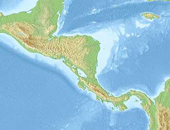
| Epicenter | 13°02′N 88°40′W / 13.04°N 88.66°WCoordinates: 13°02′N 88°40′W / 13.04°N 88.66°W |
| Areas affected |
El Salvador Guatemala |
| Casualties |
El Salvador: 944 fatalities, 5,565 injured Guatemala: 8 fatalities |
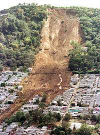
The January 2001 El Salvador earthquake struck El Salvador on January 13, 2001 at 17:33:34 UTC. The 7.6 (later estimated to be 7.7 or 7.9)[1] quake struck with the epicenter 60 miles (100 km) SW of San Miguel, El Salvador (13.04°N 88.66°W) at a depth of 60 km. At least 944 people were killed, 5,565 injured, 108,261 houses destroyed — with another 169,692 houses damaged — and more than 150,000 buildings were damaged in El Salvador.[4] About 585 of the deaths were caused by large landslides in Santa Tecla and Comasagua. As is often the case after earthquakes in El Salvador, landslides wreaked significant damage. Estimation of the number of slides is difficult because individual scarps conjoin. The total has been reported as high as 16,000, though it is unclear how this figure was arrived at.[5] Damage and injuries occurred in every department of El Salvador, particularly the departments of La Libertad and Usulután. Eight people were killed in Guatemala. The tremor was felt from Mexico City to Colombia.[2] An aftershock measuring 5.7 magnitude was felt on January 15, an event not widely reported outside the country until after the February quake, which initially was assessed by the USGS at 5.7 magnitude as well.[6]
As of February 2, 2001, more than 2,500 aftershocks had hit El Salvador, leading to additional damage and terrorizing the inhabitants. Clean water and sanitation became a matter of grave concern in many areas due to the earthquake's destruction of some $7 million to municipal drinking water systems, and tens of thousands of people were living outdoors in spite of the approaching rainy season (invierno).[4] Government and public health organizations warned of the possible spread of disease as desperate people began to scavenge debris piles — some containing severed human limbs — looking for items they could pawn to purchase needed food and other commodities.[7]
Earthquake mechanisms
The earthquakes occurred within the Cocos-Caribbean subduction zone. El Salvador sits atop the western part of the Caribbean plate, where it is overriding (subducting) the Cocos plate. Subduction zones such as this are geologically very complex and produce numerous earthquakes from multiple sources. Shallow intraplate (crustal) earthquakes occur within the crust of the overriding Caribbean plate. Deeper intraplate earthquakes occur within the subducting Cocos plate. The earthquake sequence in the El Salvador region has involved intraplate faulting in both the Cocos and Caribbean plates, with the largest earthquake in the sequence (January 13) occurring in the lower (Cocos) plate. The February 13 earthquake was a strong, shallow intraplate earthquake, occurring within the crust of the overlying Caribbean plate. This earthquake was a strike-slip faulting earthquake, which likely occurred in response to the complicated stresses in the Caribbean plate as it overrides the Cocos plate. It was about 85 km away from the 13 January earthquake and about 30 km shallower.
These two earthquakes occurred in two different plates. The occurrence of any large earthquake changes the stresses throughout the surrounding region. Aftershocks occur in response to these changes. Occasionally, other earthquakes will occur in response to the altered regional stresses. While not technically aftershocks, these earthquakes are related, becoming part of a regional earthquake sequence.
Another example of a regional earthquake sequence is the 1992 Landers-Big Bear sequence in southern California. The magnitude 7.3 Landers earthquake was followed by the magnitude 6.4 Big Bear earthquake, which occurred on a different fault approximately 36 km away.[8]
Post-quake analysis
In the days and weeks following the earthquakes, Salvadoran and foreign agencies analysed the factors that had facilitated the destruction the disasters had caused. While Salvadoran government representatives were quick to point out that the destruction had been far less than that of the 1986 earthquakes,[9] outside researchers critiqued shortcomings in preparedness and in policies toward land development that had permitted massive deforestation in the Santa Tecla area. Mexican seismologists invited by the Salvadoran government summarized their observations this way:
| “ | The construction equipment of the Ministry of Public Works was thinly stretched over hundreds of earth slumps and seemed inadequate to the task. ... The many homeless were not much in evidence; in the countryside they had been housed in temporary huts under the supervision of the armed forces, or with relatives. No homeless people were seen in the streets of San Salvador, presumably because the middle class had sustained the brunt of the damage. There was a palpable desire in the capital to forget the earthquake drama as quickly as possible.
This may be the wrong time to forget. ...According to some press reports, the developers at Las Colinas had been authorized to proceed in spite of existing zoning regulations designed to prevent residential developments on the slopes. The location was a desirable one because the Santa Tecla area was relatively safe from guerrilla operations. After pacification the pressure from developers subsided as there seems to be plenty of available land in the valley; but there is a definite need for setting up enforceable zoning regulations in order to protect the hillsides from future deforestation and encroachment by developers. ... The 2001 earthquake did not approach the level of severity of some previous earthquakes, yet it wiped out the equivalent of half the annual gross national income. A small investment in preparedness would pay off handsomely. |
” |
The government's response to the earthquakes was critiqued from different sides, with some criticizing the legislature for not approving the full amount of emergency funding urged by President Flores,[7] and others condemning what they saw as the ARENA government's contributions to the devastation. The Nicaragua-based magazine Envío argued that the conservative government's pro-business stance had fostered aggressive levels of land development, coupled with high poverty rates that forced poor rural residents to make do with inadequate but cheap building materials, asserting: "Totaling up these factors makes it clear that the consequences of a natural phenomenon like an earthquake cannot be described as 'natural' ... Describing the January 13 earthquake as a 'natural disaster' is not only irresponsible, but also a declaration of future impotence. It assumes fatalistic acceptance that no natural phenomena can be prevented and that all one can do is respond to emergencies as they arise and try to rehabilitate and reconstruct what has been destroyed." The magazine further critiqued the government's optimism about economic recovery in the aftermath of the first quake as an "insulting" minimization of the tragedy caused across the country and as an attempt to shore up the dollarization campaign that had been the focus of political attention up until the quakes.[10]
See also
References
- 1 2 Later estimates were revised to 7.7 or 7.9; see USGS Preliminary Earthquake Report Archived 2004-06-03 at the Wayback Machine. and American Red Cross Archived 2007-08-14 at the Wayback Machine., for example.
- 1 2 http://neic.usgs.gov/neis/eq_depot/2001/eq_010113/ Archived 2004-06-03 at the Wayback Machine.
- ↑ National Aeronautics and Space Administration. "Science Question of the Week" Archived 2008-05-11 at the Wayback Machine. (comparing January 2001 quakes in India and El Salvador), NASA.gov, February 8, 2001. NASA estimates the epicenter depth at 39 km.
- 1 2 Christian Aid. "El Salvador Earthquake: Emergency Update 02 Feb 2001" (press release), on ReliefWeb.int, February 2, 2001.
- ↑ Le Val Lund and Carl Sepponen, ed. (2002). Lifeline Performance of El Salvador Earthquakes of January 13 and February 13, 2001. Reston, VA: ASCE, TCLEE. ISBN 9780784406625.
- ↑ CNN. "Quake aftershock frightens Salvadorans," CNN.com, February 13, 2001.
- 1 2 CNN. "Poor sanitation fuels disease fears in aftermath of Salvador quake," CNN.com, January 20, 2001.
- ↑ "http://neic.usgs.gov/neis/eq_depot/2001/eq_010213/". Archived from the original on 2007-03-29. Retrieved 2007-03-20. External link in
|title=(help) - ↑ Ambassador Rene Leon, interviewed by Ray Suarez. "Salvadoran Earthquake," OnlineNewsHour, January 15, 2001.
- ↑ Ismael Moreno. "Dollarization and the Earthquake: Two Manmade Disasters," Revista Envío, January 2001.
External links
- First quake (USGS)
- Second quake (USGS)
- Images - International Services - El Salvador Earthquake, 2001, photos and information by the American Red Cross
- The International Seismological Centre has a bibliography and/or authoritative data for this event.
- ReliefWeb has a report on this event.
![]()