19th-century London
Part of a series on the |
|---|
| History of London |
| See also |
|
|
This article covers the 19th century history of London, during which it grew enormously to become a global city of immense importance, and the capital of the British Empire, fed by immigrants from the colonies and refugees from various conflicts and famines. Railways connecting London to the rest of Britain, as well as the London Underground were built, as were roads, a modern sewer system and many famous landmarks.
Overview
During the 19th century, London was transformed into the world's largest city and capital of the British Empire. Its population expanded from 1 million in 1801 to 6.2 million a century later (1.8% average annual growth). [1] [2] During this period, London became a global political, financial, and trading capital. In this position, it was largely unrivalled until the latter part of the century, when Paris and New York City began to threaten its dominance.
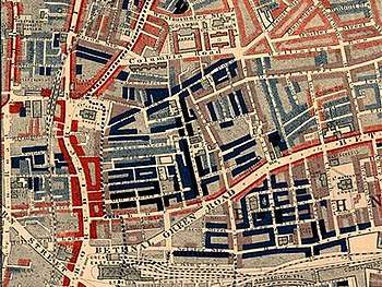
While the city grew wealthy as Britain's holdings expanded, 19th century London was also a city of poverty, where millions lived in overcrowded and unsanitary slums. Life for the poor was immortalized by Charles Dickens in such novels as Oliver Twist.
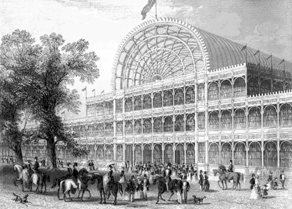
One of the most famous events of 19th century London was the Great Exhibition of 1851. Held at The Crystal Palace, the fair attracted visitors from across the world and displayed Britain at the height of its Imperial dominance.
As the capital of a massive empire, London became a magnet for immigrants from the colonies and poorer parts of Europe. A large Irish population settled in the city during the Victorian era, with many of the newcomers refugees from the Great Famine (1845-1849). At one point, Irish immigrants made up about 20% of London's population. London also became home to a sizable Jewish community, and small communities of Chinese and South Asians settled in the city.
Coming of the railways
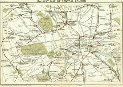
19th century London was transformed by the coming of the railways. A new network of metropolitan railways allowed for the development of suburbs in neighboring counties from which middle-class and wealthy people could commute to the centre. While this spurred the massive outward growth of the city, the growth of greater London also exacerbated the class divide, as the wealthier classes emigrated to the suburbs, leaving the poor to inhabit the inner city areas.
The first railway to be built in London was the London and Greenwich Railway a short line from London Bridge to Greenwich, which opened in 1836. This was soon followed by the opening of great rail termini which linked London to every corner of Britain. These included Euston station (1837), Paddington station (1838), Fenchurch Street station (1841), Waterloo station (1848), King's Cross station (1850), and St Pancras station (1863). From 1863, the first lines of the London Underground were constructed.
Roads
Many new roads were built after the formation of the Metropolitan Board of Works in 1855. They included the Embankment from 1864,[3] Clerkenwell and Theobalds Roads from 1874[4] and Charing Cross from 1884.[5]
1890 London had 5,728 street accidents, resulting in 144 deaths.[6]
Government
Prime minister Robert Peel established the Metropolitan Police as a police force covering the entire urban area in 1829. The force gained the nicknames of "bobbies" or "peelers" named after Robert Peel.
London's urban area grew rapidly, spreading into Islington, Paddington, Belgravia, Holborn, Finsbury, Shoreditch, Southwark and Lambeth. With London's rapid growth, towards the middle of the century, an urgent need arose to reform London's system of local government.
Outside of the City of London, which resisted any attempts to expand its boundaries to encompass the wider urban area, London had a chaotic local government system consisting of ancient parishes and vestries, working alongside an array of single-purpose boards and authorities, few of which co-operated with each other. To address this problem, in 1855 the Metropolitan Board of Works (MBW) was created to provide London with adequate infrastructure to cope with its growth. The MBW was London's first metropolitan government body.
The Metropolitan Board of Works was not a directly elected body, which made it unpopular with Londoners. In 1888 it was wound up, and replaced with the London County Council (LCC). This was the first elected London-wide administrative body. The LCC covered the same area as the MBW had done, but this area was designated as the County of London. In 1900, the county was subdivided into 28 metropolitan boroughs, which formed a more local tier of administration than the county council.
Sanitation
One of its first tasks was addressing London's sanitation problems. At the time, raw sewage was pumped straight into the River Thames. This led to repeated outbreaks of cholera in 1832, 1849, 1854, and 1866[7] (since polluted drinking water was sourced from the Thames) and culminated in The Great Stink of 1858. The 1866 cholera epidemic was the fourth in the city's history but also the last and the least deadly, [8] [9] with further epidemics forestalled by Bazalgette's improved sanitation system.
Following the Great Stink of 1858 Parliament finally gave consent for the MBW to construct a massive system of sewers. The engineer put in charge of building the new system was Joseph Bazalgette. In one of the largest civil engineering projects of the 19th century, he oversaw construction of over 1300 miles or 2100 km of tunnels and pipes under London to take away sewage and provide clean drinking water. When the London sewerage system was completed, the death toll in London dropped dramatically, and epidemics were curtailed. Bazalgette's system is still in use today.[10]

Famous buildings and landmarks
Many famous buildings and landmarks of London were constructed during the 19th century including:
See also
References
- ↑ "London through time: Population Statistics: Total Population". A vision of Britain through time. Great Britain Historical GIS. Retrieved 19 November 2009.
- ↑ "Demography of London". Wikipedia. Retrieved 6 July 2018.
- ↑ "The Victoria Embankment | British History Online". www.british-history.ac.uk. Retrieved 2017-04-21.
- ↑ "Clerkenwell Road | British History Online". www.british-history.ac.uk. Retrieved 2017-04-21.
- ↑ "Shaftesbury Avenue and Charing Cross Road | British History Online". www.british-history.ac.uk. Retrieved 2017-04-21.
- ↑ "Waikato Times, 1891-11-28". paperspast.natlib.govt.nz National Library of New Zealand. Retrieved 2017-04-21.
- ↑ City of Westminster Archives. "Cholera and the Thames". City of Westminster Archives. Retrieved 23 July 2018.
- ↑ Letheby, H. (1867). Report on the Sanitary Condition of the City of London for the year 1866-1867. London. p. 18.
- ↑ William Luckin, "The final catastrophe—cholera in London, 1866." Medical history 21#1 (1977): 32-42.
- ↑ Bill Luckin, Pollution and control: a social history of the Thames in the nineteenth century (1986).
- Inwood, Stephen. A History of London (1998) ISBN 0-333-67153-8
Further reading
Published in the 1800s-1810s
- John Feltham (1802). Picture of London, for 1803. London: Richard Phillips.
- View of London, or, the Stranger's Guide through the British Metropolis. London: B. Crosby & Co. 1804.
- David Hughson (1805). London; Being an Accurate History and Description of the British Metropolis and Its Neighbourhood. W. Stratford.
- Post-Office Annual Directory ... London. 1807.
- Picture of London, for 1807 (8th ed.). London: Richard Phillips. 1807.
- Rudolph Ackermann (1808), Microcosm of London, Illustrated by Augustus Charles Pugin and Thomas Rowlandson . 1904 reprint + Illustrations
- London and Middlesex, Beauties of England and Wales, 10 (1–4), London, 1810–1816
- John Lockie (1810), Lockie's Topography of London, London: Sold by G. and W. Nicol, OCLC 10590310
- Critchett & Woods (1814). Post-Office Annual Directory for 1814 ... Merchants, Traders, &c. of London. London.
- John Wallis (1814), London: being a complete guide to the British capital (4th ed.), London: Sherwood, Neely, and Jones, OCLC 35294736 + index
- Joseph Nightingale (1815). London and Middlesex: v.3, part 2 ... History and Description of the City and Liberty of Westminster. Beauties of England and Wales, v.10. London: J. Harris. + bibliography
- David Hughson (1817). Walks Through London.
- Abraham Rees (1819), "London", The Cyclopaedia, London: Longman, Hurst, Rees, Orme & Brown
Published in the 1820s-1830s
- Critchett & Woods (1820). Post-Office London Directory. London.
- Kent's Original London Directory: 1823. London: Henry Kent Causton. 1823.
- Thomas Allen (1827–1828). History and Antiquities of London, Westminster, Southwark, and Parts Adjacent. London: Cowie & Strange. + v.4
- Leigh's New Picture of London, London: Samuel Leigh, 1830
- Cruchley's Picture of London, London: G. F. Cruchley, 1831
- Thomas H. Shepherd (1831), London and its Environs in the Nineteenth Century, London: Jones & Co., OCLC 10348078
- Francis Coghlan (c. 1830s). Stranger's London Guide (2nd ed.). London: Thomas Geeves.
- James Elmes (1831). Topographical Dictionary of London and Its Environs. London: Whittaker, Treacher and Arnot.
- Kidd's New Guide to the 'Lions' of London; or, the Stranger's Directory. London: William Kidd. 1832.
- Abraham Booth (1839), Stranger's Intellectual Guide to London for 1839-40, London: H. Hooper
- "London". Penny Cyclopaedia. 14. London: Charles Knight. 1839. pp. 109–129.
Published in the 1840s-1850s
- Charles Knight, ed. (1841–1844), London, London: C. Knight & Co. + v.2, v.4, v.5, v.6
- Robson's London Directory ... for 1842 (23rd ed.), London: Robson, 1842
- Post Office London Directory, 1843. London: W. Kelly & Co.
- Mogg's New Picture of London (11th ed.), London: Edward Mogg, 1848
- A Christmas Carol, London: Charles Dickens, 1843
- Hogben's Strangers' Guide to London, London: John Hogben, 1850
- The British Metropolis in 1851: A Classified Guide to London. Arthur Hall, Virtue & Co. 1851.
- Henry Mayhew (1851). London Labour and the London Poor.
- William Gaspey (1851), Tallis's Illustrated London, London and New York: J. Tallis and Company, OCLC 1350917
- Post Office London Directory. 1852 – via University of Leicester, Library.
- Pictorial Handbook of London, London: Henry G. Bohn, 1854
- Post Office (1856). Principal Streets and Places in London and its Environs. London.
- Peter Cunningham (1857), London in 1857, London: John Murray
Published in the 1860s-1870s
- John Camden Hotten (1860), A dictionary of modern slang, cant, and vulgar words, used at the present day in the streets of London (2nd ed.), London: J. C. Hotten
- London and its Environs, Edinburgh: A. & C. Black, 1862, OCLC 1995082 + index
- Bradshaw's Monthly Alphabetical Hand-book through London and its Environs, London: W.J. Adams, 1862
- Peter Cunningham (1863), London as it is, London: John Murray, OCLC 9520918
- John Timbs (1867), Curiosities of London (2nd ed.), London: J. C. Hotten, OCLC 12878129 + Index
- Collins' Illustrated Guide to London & Neighbourhood, William Collins, Sons, & Co., 1873, OCLC 65849744
- Kay-Shuttleworth, U. J.; Waterlow, Sir Sydney (1874). Dwellings of working-people in London. London: Ridgway.
- James Thorne (1876), Handbook to the Environs of London, London: John Murray
Published in the 1880s-1890s
- Herbert Fry (1880), London in 1880, London: David Bogue
- John Parker Anderson (1881), "London", Book of British Topography: a Classified Catalogue of the Topographical Works in the Library of the British Museum Relating to Great Britain and Ireland, London: W. Satchell, pp. 178–213
- W. J. Loftie (1881), Tourist's Guide through London, London: Edward Stanford
- Charles Dickens, Jr. (1882), Dickens's Dictionary of London, London: Macmillan & Co.
- Gillig, Charles Alvin (1885). Charles A. Gillig's New Guide to London.
- London and Its Environs (6th ed.), Leipsic: Karl Baedeker, 1887
- Walter Thornbury (1887), Old and New London (2nd ed.), London: Cassell + (1878 ed.)
- London Congregational Union (1883). The bitter cry of outcast London. London: James Clarke & Co.
- W. J. Loftie (1889), London, Historic Towns (2nd ed.), London: Longmans, Green, and Co.
Published in the 20th century
- Aldon D. Bell (1967), London in the Age of Dickens, Centers of Civilization Series, USA: University of Oklahoma Press, OL 5563552M
External links
| Wikimedia Commons has media related to London in the 19th century. |
- Victorian London
- Circa 1896 Late 19th Century London then and now
- The Twilight City An exploration of vagrancy and streetwalkers in late Victorian London
- Dictionary of Victorian London A resource for anyone interested in life in Victorian London.