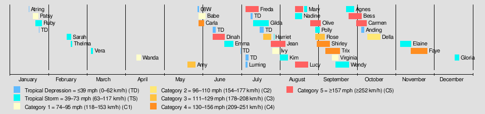
| 1965 Pacific typhoon season |
|---|
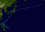
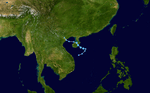
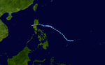
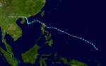
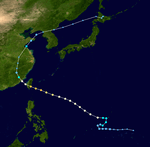
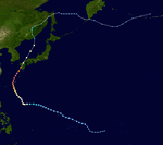
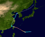
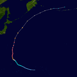
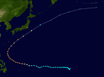
 Season summary map |
| Seasonal boundaries |
|---|
| First system formed |
January 16, 1965 |
|---|
| Last system dissipated |
December 21, 1965 |
|---|
| Strongest storm |
|---|
|
|
| Name |
Bess |
|---|
| • Maximum winds |
280 km/h (175 mph)
(1-minute sustained) |
|---|
| • Lowest pressure |
900 hPa (mbar) |
|---|
|
|
| Seasonal statistics |
|---|
| Total depressions |
44 |
|---|
| Total storms |
35 |
|---|
| Typhoons |
21 |
|---|
| Super typhoons |
11 (unofficial)
(record high; tied with 1997) |
|---|
| Total fatalities |
Unknown |
|---|
| Total damage |
Unknown |
|---|
| Related articles |
|---|
|
|
|
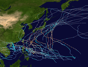
The 1965 Pacific typhoon season has no official bounds; it ran year-round in 1965, but most tropical cyclones tend to form in the northwestern Pacific Ocean between June and December. These dates conventionally delimit the period of each year when most tropical cyclones form in the northwestern Pacific Ocean.
The scope of this article is limited to the Pacific Ocean, north of the equator and west of the international date line. Storms that form east of the date line and north of the equator are called hurricanes; see 1965 Pacific hurricane season. Tropical Storms formed in the entire west pacific basin were assigned a name by the Joint Typhoon Warning Center. Tropical depressions in this basin have the "W" suffix added to their number. Tropical depressions that enter or form in the Philippine area of responsibility are assigned a name by the Philippine Atmospheric, Geophysical and Astronomical Services Administration or PAGASA. This can often result in the same storm having two names.
Systems
40 tropical depressions formed this year in the Western Pacific, of which 35 became tropical storms. 21 storms reached typhoon intensity, of which 11 reached super typhoon strength.
Tropical Depression Atring
|
Tropical depression (PAGASA) |
|
|
| Duration |
January 16 – January 17 |
|---|
| Peak intensity |
55 km/h (35 mph) (10-min) 1003 hPa (mbar) |
|---|
Possibly regenerated into Typhoon Patsy.
Typhoon Patsy (Bining)
|
Category 1 typhoon (SSHWS) |
|
|
| Duration |
January 19 – January 23 |
|---|
| Peak intensity |
120 km/h (75 mph) (1-min) 990 hPa (mbar) |
|---|
Tropical Storm Ruth
|
Tropical storm (SSHWS) |
|
|
| Duration |
January 21 – January 26 |
|---|
| Peak intensity |
110 km/h (70 mph) (1-min) 994 hPa (mbar) |
|---|
CMA Tropical Depression 4
|
Tropical depression (CMA) |
|
|
| Duration |
January 24 – January 24 |
|---|
| Peak intensity |
45 km/h (30 mph) (10-min) 1002 hPa (mbar) |
|---|
The depression stayed at sea and it did not last long at all.
Tropical Storm Sarah
|
Tropical storm (SSHWS) |
|
|
| Duration |
February 15 – February 18 |
|---|
| Peak intensity |
85 km/h (50 mph) (1-min) 1002 hPa (mbar) |
|---|
Tropical Storm Thelma (Kuring)
|
Tropical storm (SSHWS) |
|
|
| Duration |
February 18 – February 19 |
|---|
| Peak intensity |
75 km/h (45 mph) (1-min) 1000 hPa (mbar) |
|---|
Thelma was short-lived.
Tropical Storm Vera (Daling)
|
Tropical storm (SSHWS) |
|
|
| Duration |
March 6 – March 7 |
|---|
| Peak intensity |
75 km/h (45 mph) (1-min) 1004 hPa (mbar) |
|---|
Vera did not last long.
Typhoon Wanda
|
Category 1 typhoon (SSHWS) |
|
|
| Duration |
April 11 – April 14 |
|---|
| Peak intensity |
120 km/h (75 mph) (1-min) 996 hPa (mbar) |
|---|
Wanda did not impact land.
Typhoon Amy (Elang)
|
Category 3 typhoon (SSHWS) |
|
|
| Duration |
May 21 – May 27 |
|---|
| Peak intensity |
185 km/h (115 mph) (1-min) 976 hPa (mbar) |
|---|
Tropical Depression 08W
|
Tropical depression (SSHWS) |
|
|
| Duration |
May 29 – May 30 |
|---|
| Peak intensity |
45 km/h (30 mph) (1-min) |
|---|
Typhoon Babe
|
Category 1 typhoon (SSHWS) |
|
|
| Duration |
May 30 – June 4 |
|---|
| Peak intensity |
150 km/h (90 mph) (1-min) 990 hPa (mbar) |
|---|
Typhoon Carla (Goring)
|
Category 4 typhoon (SSHWS) |
|
|
| Duration |
May 30 – June 3 |
|---|
| Peak intensity |
220 km/h (140 mph) (1-min) 995 hPa (mbar) |
|---|
CMA Tropical Depression 12
|
Tropical depression (CMA) |
|
|
| Duration |
June 10 – June 12 |
|---|
| Peak intensity |
45 km/h (30 mph) (10-min) 1000 hPa (mbar) |
|---|
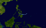
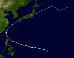
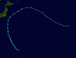
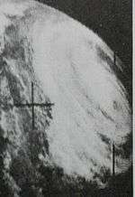
Super Typhoon Dinah (Huling)
|
Category 5 super typhoon (SSHWS) |
|
|
| Duration |
June 10 – June 19 |
|---|
| Peak intensity |
295 km/h (185 mph) (1-min) 935 hPa (mbar) |
|---|
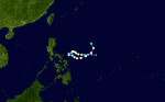
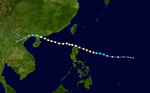
A surge in the southern hemisphere indraft developed into Tropical Depression 11W on June 12 to the east of the Philippines. It tracked west-northwestward, quickly strengthening to a tropical storm that day and a typhoon on the 13th. Dinah continued to quickly intensify as it turned to the northwest, and attained a peak of 185 mph on the 17th to the northeast of Luzon. Its southerly inflow was cut off, and Dinah weakened as it turned to the north. It hit southern Taiwan on the 18th as a 140 mph typhoon, and weakened greatly over the island to a tropical storm. At this time, Dinah exhibited a rare false radar eye. Dinah turned to the northeast, where it became extratropical near Japan on June 20. The storm killed 45 people on its path, and destroyed 5000 homes on Taiwan.
Tropical Storm Emma (Ibiang)
|
Tropical storm (SSHWS) |
|
|
| Duration |
June 19 – June 26 |
|---|
| Peak intensity |
95 km/h (60 mph) (1-min) 996 hPa (mbar) |
|---|
CMA Tropical Depression 15
|
Tropical depression (CMA) |
|
|
| Duration |
July 2 – July 2 |
|---|
| Peak intensity |
55 km/h (35 mph) (10-min) 1004 hPa (mbar) |
|---|
CMA Tropical Depression 16
|
Tropical depression (CMA) |
|
|
| Duration |
July 6 – July 8 |
|---|
| Peak intensity |
55 km/h (35 mph) (10-min) 1002 hPa (mbar) |
|---|
Tropical Depression 13W (Luming)
|
Tropical storm (PAGASA) |
|
Tropical depression (SSHWS) |
|
|
| Duration |
July 6 – July 9 |
|---|
| Peak intensity |
65 km/h (40 mph) (10-min) 1004 hPa (mbar) |
|---|
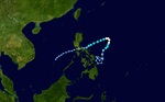
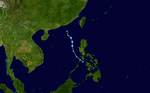
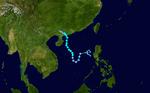
Super Typhoon Freda (Miling)
|
Category 5 super typhoon (SSHWS) |
|
|
| Duration |
July 6 – July 16 |
|---|
| Peak intensity |
260 km/h (160 mph) (1-min) 925 hPa (mbar) |
|---|
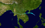
160 mph Super Typhoon Freda, which began its life on July 6, hit northern Luzon on the 13th. It crossed the island and the South China Sea, where it hit Hainan Island as a 115 mph typhoon on the 15th. Freda dissipated the next day over China, after causing heavy flooding killing an unknown number of people. In Hong Kong Freda killed 2 people.[1]
CMA Tropical Depression 18
|
Tropical depression (CMA) |
|
|
| Duration |
July 10 – July 11 |
|---|
| Peak intensity |
45 km/h (30 mph) (10-min) 999 hPa (mbar) |
|---|
The depression stayed away from land, yet it did not last long.
Tropical Storm Gilda (Narsing)
|
Tropical storm (SSHWS) |
|
|
| Duration |
July 12 – July 24 |
|---|
| Peak intensity |
110 km/h (70 mph) (1-min) 985 hPa (mbar) |
|---|
Gilda did not last long, although it caused some damage.
CMA Tropical Depression 20
|
Tropical depression (CMA) |
|
|
| Duration |
July 17 – July 20 |
|---|
| Peak intensity |
55 km/h (35 mph) (10-min) |
|---|
The depression did not last long.
Typhoon Harriet (Openg)
|
Category 3 typhoon (SSHWS) |
|
|
| Duration |
July 20 – July 28 |
|---|
| Peak intensity |
185 km/h (115 mph) (1-min) 970 hPa (mbar) |
|---|
Harriet hit Tawian as a Category 3 typhoon.
Super Typhoon Jean (Rubing)
|
Category 5 super typhoon (SSHWS) |
|
|
| Duration |
July 26 – August 6 |
|---|
| Peak intensity |
260 km/h (160 mph) (1-min) 940 hPa (mbar) |
|---|
Super Typhoon Jean, after reaching a peak of 160 mph on August 3, weakened slightly to hit southwestern Japan as a 150 mph super typhoon on August 5. The typhoon brought heavy winds to Southern Japan before becoming extratropical on the 7th. Typhoon Jean killed 28 people throughout Southern Japan.[2]
Typhoon Ivy (Pining)
|
Category 1 typhoon (SSHWS) |
|
|
| Duration |
July 27 – August 1 |
|---|
| Peak intensity |
150 km/h (90 mph) (1-min) 990 hPa (mbar) |
|---|
Ivy did a loop.
Tropical Storm Kim
|
Tropical storm (SSHWS) |
|
|
| Duration |
August 2 – August 8 |
|---|
| Peak intensity |
110 km/h (70 mph) (1-min) 990 hPa (mbar) |
|---|
Kim stayed at sea.
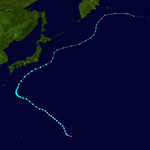
Super Typhoon Lucy
|
Category 5 super typhoon (SSHWS) |
|
|
| Duration |
August 14 – August 24 |
|---|
| Peak intensity |
280 km/h (175 mph) (1-min) 940 hPa (mbar) |
|---|
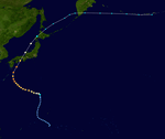
On August 14 a tropical depression formed and was named Lucy after it became a tropical storm. Lucy became a typhoon and soon into a 175 mph super typhoon. Lucy weakened and struck Japan as a minimal typhoon. Lucy dissipated on August 24.
Super Typhoon Mary (Saling)
|
Category 5 super typhoon (SSHWS) |
|
|
| Duration |
August 14 – August 23 |
|---|
| Peak intensity |
280 km/h (175 mph) (1-min) 950 hPa (mbar) |
|---|
175 mph Super Typhoon Mary weakened from its peak to hit eastern Taiwan on August 18 as a 105 mph typhoon. The typhoon brought strong winds and heavy rain before dissipating over China on the 20th.
Tropical Storm Nadine
|
Tropical storm (SSHWS) |
|
|
| Duration |
August 14 – August 19 |
|---|
| Peak intensity |
110 km/h (70 mph) (1-min) 990 hPa (mbar) |
|---|
Super Typhoon Olive
|
Category 5 super typhoon (SSHWS) |
|
|
| Duration |
August 26 – September 3 |
|---|
| Peak intensity |
280 km/h (175 mph) (1-min) 940 hPa (mbar) |
|---|
Tropical Storm Polly (Tasing)
|
Tropical storm (SSHWS) |
|
|
| Duration |
August 30 – September 2 |
|---|
| Peak intensity |
85 km/h (50 mph) (1-min) 994 hPa (mbar) |
|---|
Typhoon Rose (Unding)
|
Category 3 typhoon (SSHWS) |
|
|
| Duration |
August 30 – September 6 |
|---|
| Peak intensity |
185 km/h (115 mph) (1-min) 980 hPa (mbar) |
|---|
Super Typhoon Shirley
|
Category 4 super typhoon (SSHWS) |
|
|
| Duration |
August 31 – September 10 |
|---|
| Peak intensity |
240 km/h (150 mph) (1-min) 940 hPa (mbar) |
|---|
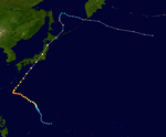
130 mph Typhoon Shirley, after weakening from a peak of 150 mph, hit southern Japan on September 10, causing moderate damage and heavy rain. Resulting floods and landslides killed 67 people and left 6 missing.[2]
Super Typhoon Trix (Walding)
|
Category 4 super typhoon (SSHWS) |
|
|
| Duration |
September 7 – September 18 |
|---|
| Peak intensity |
240 km/h (150 mph) (1-min) 935 hPa (mbar) |
|---|
Typhoon Trix struck central Honshū Island in Japan just days after Typhoon Shirley. Trix caused heavy rains 98 people were killed and 9 were missing due to the resulting flooding and landslides.[2]
Typhoon Virginia
|
Category 1 typhoon (SSHWS) |
|
|
| Duration |
September 12 – September 17 |
|---|
| Peak intensity |
120 km/h (75 mph) (1-min) 980 hPa (mbar) |
|---|
Tropical Storm Wendy (Yeyeng)
|
Tropical storm (SSHWS) |
|
|
| Duration |
September 15 – September 25 |
|---|
| Peak intensity |
95 km/h (60 mph) (1-min) 986 hPa (mbar) |
|---|
Tropical Storm Agnes
|
Tropical storm (SSHWS) |
|
|
| Duration |
September 23 – September 29 |
|---|
| Peak intensity |
110 km/h (70 mph) (1-min) 990 hPa (mbar) |
|---|
Tropical Storm Agnes struck Hong Kong killing 5 people.[1]
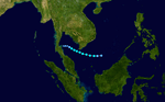
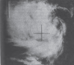
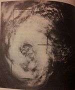
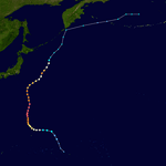
Super Typhoon Bess
|
Category 5 super typhoon (SSHWS) |
|
|
| Duration |
September 25 – October 5 |
|---|
| Peak intensity |
280 km/h (175 mph) (1-min) 900 hPa (mbar) |
|---|
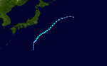
Bess was the strongest storm of the season. The storm formed on September 27 northeast of Palau and dissipated on October 6 north of Japan.
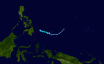
Super Typhoon Carmen
|
Category 5 super typhoon (SSHWS) |
|
|
| Duration |
October 1 – October 9 |
|---|
| Peak intensity |
280 km/h (175 mph) (1-min) 910 hPa (mbar) |
|---|
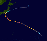
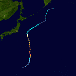
Carmen rapidly intensified in the vicinity of Agrihan, the pressure was at 970 hectopascals at 18:00 UTC on October 5, and then it rapidly decreased to 914 hectopascals at 18:00 UTC on October 6, and reached a maximum wind speed of 175 miles per hour (282 km/h). On 7 October 1965, seven Japanese fishing vessels capsized in the stormy seas. According to the Japan Coast Guard official confirmed report, 209 crewmen were killed.
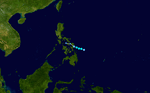
Tropical Depression Anding
Anding did not last long.
|
Tropical depression (PAGASA) |
|
|
| Duration |
October 5 – October 7 |
|---|
| Peak intensity |
55 km/h (35 mph) (10-min) |
|---|
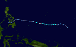
Typhoon Della
|
Category 2 typhoon (SSHWS) |
|
|
| Duration |
October 10 – October 20 |
|---|
| Peak intensity |
155 km/h (100 mph) (1-min) 975 hPa (mbar) |
|---|
Della stayed at sea.
Tropical Storm Elaine
|
Tropical storm (SSHWS) |
|
|
| Duration |
November 5 – November 13 |
|---|
| Peak intensity |
95 km/h (60 mph) (1-min) 996 hPa (mbar) |
|---|
Super Typhoon Faye (Binang)
|
Category 4 super typhoon (SSHWS) |
|
|
| Duration |
November 13 – November 26 |
|---|
| Peak intensity |
250 km/h (155 mph) (1-min) 930 hPa (mbar) |
|---|
Tropical Storm Gloria
|
Tropical storm (SSHWS) |
|
|
| Duration |
December 18 – December 21 |
|---|
| Peak intensity |
75 km/h (45 mph) (1-min) 1003 hPa (mbar) |
|---|