| 1950 Pacific typhoon season |
|---|
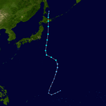
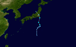
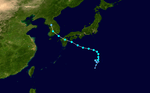
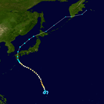
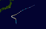
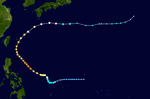
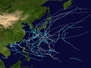 Season summary map |
| Seasonal boundaries |
|---|
| First system formed |
April 12, 1950 |
|---|
| Last system dissipated |
January 1, 1951 |
|---|
| Strongest storm |
|---|
|
|
| Name |
Clara |
|---|
| • Maximum winds |
230 km/h (145 mph)
(1-minute sustained) |
|---|
| • Lowest pressure |
899 hPa (mbar) |
|---|
|
|
| Seasonal statistics |
|---|
| Total storms |
18 |
|---|
| Typhoons |
12 |
|---|
| Super typhoons |
1 (unofficial) |
|---|
| Total fatalities |
544 total |
|---|
| Total damage |
Unknown |
|---|
| Related articles |
|---|
|
|
|
The 1950 Pacific typhoon season has no official bounds; it ran year-round in 1950, but most tropical cyclones tend to form in the northwestern Pacific Ocean between June and December. These dates conventionally delimit the period of each year when most tropical cyclones form in the northwestern Pacific Ocean.
The scope of this article is limited to the Pacific Ocean, north of the equator and west of the international date line. Storms that form east of the date line and north of the equator are called hurricanes; see 1950 Pacific hurricane season. Tropical Storms formed in the entire west pacific basin were assigned a name by the North Pacific Typhoon Warning Service.
Systems
Severe Tropical Storm One
|
Severe tropical storm (CMA) |
|
|
| Duration |
April 12 – April 15 |
|---|
| Peak intensity |
110 km/h (70 mph) (10-min) 984 hPa (mbar) |
|---|
Typhoon Doris
|
Typhoon (JMA) |
|
Category 4 super typhoon (SSHWS) |
|
|
| Duration |
May 6 – May 14 |
|---|
| Peak intensity |
240 km/h (150 mph) (1-min) 922 hPa (mbar) |
|---|
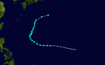
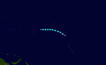
Doris was an intense category 4 Super Typhoon that mostly remained out to sea. It formed on May 6, peaked as a strong category 4, and then dissipated on May 14. Doris reached a very low pressure of 922 mbar.
Tropical Storm 02W
|
Tropical Storm (JMA) |
|
Tropical storm (SSHWS) |
|
|
| Duration |
June 5 – June 9 |
|---|
| Peak intensity |
65 km/h (40 mph) (1-min) 997 hPa (mbar) |
|---|
Typhoon Elsie
|
Typhoon (JMA) |
|
Category 1 typhoon (SSHWS) |
|
|
| Duration |
June 22 – June 24 |
|---|
| Peak intensity |
140 km/h (85 mph) (1-min) 981 hPa (mbar) |
|---|
CMA Severe Tropical Storm Six
|
Severe tropical storm (CMA) |
|
|
| Duration |
July 12 – July 15 |
|---|
| Peak intensity |
95 km/h (60 mph) (10-min) 990 hPa (mbar) |
|---|
Typhoon Flossie
|
Typhoon (JMA) |
|
Tropical storm (SSHWS) |
|
|
| Duration |
July 15 – July 19 |
|---|
| Peak intensity |
110 km/h (70 mph) (1-min) 993 hPa (mbar) |
|---|
Typhoon Grace
|
Typhoon (JMA) |
|
Category 1 typhoon (SSHWS) |
|
|
| Duration |
July 15 – July 22 |
|---|
| Peak intensity |
130 km/h (80 mph) (1-min) 981 hPa (mbar) |
|---|
Tropical Storm Helene
|
Tropical Storm (JMA) |
|
Tropical storm (SSHWS) |
|
|
| Duration |
July 24 – August 1 |
|---|
| Peak intensity |
95 km/h (60 mph) (1-min) 990 hPa (mbar) |
|---|
Tropical Storm Thirteen
|
Tropical storm (CMA) |
|
|
| Duration |
August 2 – August 4 |
|---|
| Peak intensity |
75 km/h (45 mph) (10-min) 992 hPa (mbar) |
|---|
Tropical Storm Fifteen
|
Tropical storm (CMA) |
|
|
| Duration |
August 3 – August 4 |
|---|
| Peak intensity |
75 km/h (45 mph) (10-min) 998 hPa (mbar) |
|---|
Tropical Storm Sixteen
|
Tropical Storm (JMA) |
|
|
| Duration |
August 4 – August 6 |
|---|
| Peak intensity |
75 km/h (45 mph) (10-min) 996 hPa (mbar) |
|---|
Typhoon Ida
|
Typhoon (JMA) |
|
Category 1 typhoon (SSHWS) |
|
|
| Duration |
August 9 – August 22 |
|---|
| Peak intensity |
140 km/h (85 mph) (1-min) 973 hPa (mbar) |
|---|
Tropical Depression Twenty
|
Tropical depression (JMA) |
|
|
| Duration |
August 10 – August 14 |
|---|
| Peak intensity |
95 km/h (60 mph) (10-min) 990 hPa (mbar) |
|---|
Severe Tropical Storm Twenty-one
|
Severe tropical storm (CMA) |
|
|
| Duration |
August 11 – August 14 |
|---|
| Peak intensity |
110 km/h (70 mph) (10-min) 980 hPa (mbar) |
|---|
Severe Tropical Storm Twenty-three
|
Tropical Storm (JMA) |
|
|
| Duration |
August 14 – August 22 |
|---|
| Peak intensity |
110 km/h (70 mph) (10-min) 990 hPa (mbar) |
|---|
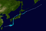
Typhoon Jane
|
Typhoon (JMA) |
|
Category 3 typhoon (SSHWS) |
|
|
| Duration |
August 29 – September 3 |
|---|
| Peak intensity |
185 km/h (115 mph) (1-min) 943 hPa (mbar) |
|---|
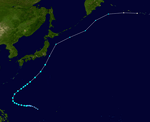
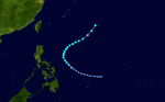
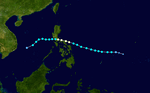
Typhoon Jane struck the island of Shikoku in Japan on the 3rd of September. Resulting flooding and landslides killed 539 people.
In late August, a depression formed and quickly intensified into a tropical storm and was given the name Jane. The storm drifted west-northwestward and intensified into a typhoon. Jane gradually curved to the north and intensified to a category 2 typhoon. Jane shortly reached category 3 status and peak intensity at 185 km/h (115 mph). The typhoon accelerated to the north-northeast and weakened to a category 2 storm and made landfall in the modern-day Osaka-Kobe-Kyoto area. Jane crossed Kyoto Prefecture and weakened to a tropical storm and crossed the Noto Peninsula and reentered the Sea of Japan and passed just west of Sado Island. The storm struck eastern Aomori Prefecture and crossed the Tsugaru Straits and made a final landfall on the south coast of Hokkaido Prefecture. Jane crossed Hokkaido and dissipated south of the Kuril Islands.
Typhoon Kezia
|
Typhoon (JMA) |
|
Category 3 typhoon (SSHWS) |
|
|
| Duration |
September 4 – September 14 |
|---|
| Peak intensity |
185 km/h (115 mph) (1-min) 945 hPa (mbar) |
|---|
On September 13 Typhoon Kezia hit part of the fleet off Kyushu.
P-51 Mustangs belonging to No. 77 Squadron RAAF were grounded at Iwakuni because of the typhoon on September 13 and 14.[1]
Severe Tropical Storm Twenty-six
|
Severe tropical storm (CMA) |
|
|
| Duration |
September 6 – September 8 |
|---|
| Peak intensity |
95 km/h (60 mph) (10-min) 995 hPa (mbar) |
|---|
Tropical Storm Lucretia
|
Tropical Storm (JMA) |
|
Tropical storm (SSHWS) |
|
|
| Duration |
September 14 – September 19 |
|---|
| Peak intensity |
100 km/h (65 mph) (1-min) 987 hPa (mbar) |
|---|
Typhoon Missatha
|
Typhoon (JMA) |
|
Tropical storm (SSHWS) |
|
|
| Duration |
September 13 – September 18 |
|---|
| Peak intensity |
100 km/h (65 mph) (1-min) 984 hPa (mbar) |
|---|
Typhoon Ossia
|
Typhoon (JMA) |
|
Category 3 typhoon (SSHWS) |
|
|
| Duration |
September 27 – October 6 |
|---|
| Peak intensity |
185 km/h (115 mph) (1-min) 966 hPa (mbar) |
|---|
Typhoon Petie
|
Typhoon (JMA) |
|
Category 2 typhoon (SSHWS) |
|
|
| Duration |
October 18 – October 24 |
|---|
| Peak intensity |
165 km/h (105 mph) (1-min) 978 hPa (mbar) |
|---|
Severe Tropical Storm Thirty-five
|
Severe tropical storm (CMA) |
|
|
| Duration |
October 26 – October 31 |
|---|
| Peak intensity |
95 km/h (60 mph) (10-min) 995 hPa (mbar) |
|---|
Typhoon Ruby
|
Typhoon (JMA) |
|
Category 3 typhoon (SSHWS) |
|
|
| Duration |
October 27 – October 31 |
|---|
| Peak intensity |
185 km/h (115 mph) (1-min) 918 hPa (mbar) |
|---|
Typhoon Billie
|
Typhoon (JMA) |
|
Category 1 typhoon (SSHWS) |
|
|
| Duration |
November 4 – November 9 |
|---|
| Peak intensity |
150 km/h (90 mph) (1-min) 985 hPa (mbar) |
|---|
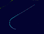
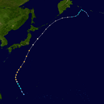
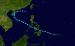
Typhoon Clara
|
Typhoon (JMA) |
|
Category 4 typhoon (SSHWS) |
|
|
| Duration |
November 4 – November 12 |
|---|
| Peak intensity |
230 km/h (145 mph) (1-min) 899 hPa (mbar) |
|---|
Tropical Storm Delilah
|
Tropical Storm (JMA) |
|
Tropical storm (SSHWS) |
|
|
| Duration |
November 19 – November 25 |
|---|
| Peak intensity |
110 km/h (70 mph) (1-min) 989 hPa (mbar) |
|---|
This Tropical Storm affected the Philippines.
Severe Tropical Storm Ellen
|
Severe tropical storm (CMA) |
|
|
| Duration |
December 11 – December 13 |
|---|
| Peak intensity |
110 km/h (70 mph) (10-min) 990 hPa (mbar) |
|---|
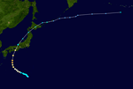
Typhoon Fran
|
Typhoon (JMA) |
|
Category 1 typhoon (SSHWS) |
|
|
| Duration |
December 26 – January 1 |
|---|
| Peak intensity |
150 km/h (90 mph) (1-min) 980 hPa (mbar) |
|---|
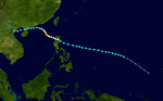
Typhoon Fran was a late season storm that struck the northern Philippines killing 5 people.[2]
Storm names
The names Delilah, Helene, Jane, Kezia, Lucretia, Missatha, Ossia, and Petie were retired after this year and replaced with Dot, Helen, June, Kathy, Lorna, Marie, Olga, and Pamela.
- Doris
- Elsie
- Flossie
- Grace
- Helene
- Ida
- Jane
- Kezia
- Lucretia
- Missatha
|
- Nancy
- Ossia
- Petie
- Ruby
- Anita
- Billie
- Clara
- Delilah
- Ellen
- Fran
|