1933 Texas tropical storm
| Tropical storm (SSHWS/NWS) | |
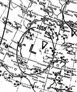 Surface weather analysis of the storm on July 21 | |
| Formed | July 14, 1933 |
|---|---|
| Dissipated | July 27, 1933 |
| (Extratropical after July 23, 1933) | |
| Highest winds |
1-minute sustained: 50 mph (85 km/h) |
| Lowest pressure | 999 mbar (hPa); 29.5 inHg |
| Damage | $1.5 million (1933 USD) |
| Areas affected | Jamaica, Belize, Yucatán Peninsula, South-Central United States |
| Part of the 1933 Atlantic hurricane season | |
The 1933 Texas tropical storm produced record rainfall in the south-central United States in July of the 1933 Atlantic hurricane season. It was the third storm of the season, developing on July 14 near the Lesser Antilles. While moving westward through the Caribbean Sea, the cyclone passed just south of Jamaica on July 16. The storm dropped heavy rainfall on the island that caused flooding and road washouts. On July 18, the storm struck Belize and later moved across the Yucatán Peninsula. Initially it was believed that the storm continued into Mexico and dissipated while another storm formed to its northeast, but it was discovered in 2012 that the storm followed one continuous track.
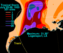
On July 23, the storm struck southeastern Texas at its peak intensity of 50 mph (85 km/h). It moved inland and transitioned into an extratropical cyclone. Turning eastward, the storm dropped torrential rainfall in eastern Texas and western Louisiana, peaking at 21.3 in (540 mm) in Logansport, Louisiana. Several stations reported record rainfall, including Shreveport, Louisiana where its 24‑hour amount remained the highest daily total as of 2008. High rains left about $1.5 million[nb 1] in crop damage between two Texas counties. The rains caused rivers to exceed their banks, forcing evacuations and road closures.
Meteorological history
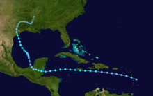
On July 14, a tropical depression developed near Saint Kitts.[nb 2] Initially it moved west-northwestward before turning to the west, and on July 15 it passed south of Hispaniola. That day, ships in the region confirmed the presence of a closed circulation. The depression was assessed to have intensified into a tropical storm at 0000 UTC on July 16, before passing just south of Jamaica later that day. After affecting the island, the storm turned to the west-southwest, reaching peak winds of 50 mph (85 km/h) early on July 18. Later that day, a ship reported a pressure of 995 mbar (29.4 inHg), which was adjusted to 999 mbar (29.5 inHg) to compensate a bias in the ship's barometer. Around 1500 UTC on July 18, the storm made landfall near Belize City, Belize at its peak intensity.[1]
After moving ashore, the storm quickly weakened into a tropical depression while crossing the Yucatán Peninsula. Late on July 19, it emerged into the Bay of Campeche.[nb 3] It turned to the northwest due to a ridge moving eastward,[3] and the system re-intensified into a tropical storm on July 21. At around 0800 UTC on July 23, the storm moved ashore on Matagorda Bay in southeastern Texas with winds of about 45 mph (75 km/h). The storm again weakened to a tropical depression shortly after landfall, before turning to the north and north-northeast. On July 24, the cyclone began interacting with a cold front, and became extratropical.[1] It tracked slowly eastward across eastern Texas and northern Louisiana due to a high pressure area to the north.[4] It later moved along the Mississippi River, and early on July 27, the front absorbed the depression along the border of Arkansas and Mississippi.[1]
Impact
While passing south of Jamaica, the storm produced the heavy rainfall in the month of July in at least 40 years, which overflowed rivers.[5] Both Kingston and Saint Andrew Parish reported 9 in (230 mm), causing flooding and landslides.[6] The storm washed out roads, most of them unpaved, and one bridge was wrecked;[7] this disrupted the regional transportation.[6] The storm also cut telegraph lines between Kingston and the eastern portion of the island.[5] It later moved across Belize and the Yucatán Peninsula, although no stations reported gale-force winds or low pressures.[1]
Despite being a weak tropical cyclone, the storm dropped heavy rainfall in eastern Texas and northwestern Louisiana. Some areas received 5.9 in (150 mm) in as little as six hours, and about 50,000 sq mi (130,000 km2) reported 10.4 in (260 mm). The highest rainfall total was 21.3 in (540 mm) in Logansport, Louisiana.[3] As of 2009, this was the seventh highest total on record in the state, although three of the amounts were from the same storm. Logansport also reported a 24‑hour total of 18 in (460 mm), which set the record for the highest daily rainfall total there in July.[8] A secondary rainfall maxima of 19.4 in (490 mm) was observed in Shreveport,[9] of which 12.4 in (310 mm) of rain fell in 24 hours; this was the highest daily total on record for the site, and remains the highest as of 2008.[10] Alexandria also broke its 24‑hour rainfall record in July with a total of 9.75 in (248 mm) on July 25.[8] Heavy rains spread into southern Arkansas and northwestern Mississippi.[3]
High rains in eastern Texas, totaling over 10 in (250 mm), flooded roads in Shelby and Panola counties; damage in the two counties collectively totaled $1.5 million. Storm-related flooding washed out a bridge in Henderson and portions of the Santa Fe Railway line between Carthage and Longview.[4] Five people required rescue after being trapped in a fast-moving river.[11] The rains in the region were considered the heaviest in 17 years, and leaving severe damage to corn, cotton, and watermelon crops.[4] Similarly, the floods damaged cotton and other crops in northern Louisiana, totaling several million dollars in losses. The rains caused many streams to exceed their banks,[9] including one creek near Converse that flooded roads and railways.[8] The floods forced families to evacuate in low-lying areas of northern Louisiana.[11] The rainfall in Shreveport caused the worst floods related to a tropical cyclone on record.[12] While the storm was dropping heavy rainfall, it produced thunderstorms and gusty winds along the Texas and Louisiana coastlines.[9] A severe thunderstorm related to the storm damaged roofs and windows in Alexandria, Louisiana.[8]
See also
Notes
- ↑ All damage totals are in 1933 United States dollars unless otherwise noted.
- ↑ Due to lack of observations, the Atlantic hurricane reanalysis project noted that the depression could have formed on July 13.[1]
- ↑ Originally, the storm was assessed as two separate storms. The first was considered to have dissipated over Veracruz, Mexico on July 19, and the second was thought to have formed on July 21 in the Gulf of Mexico. The Atlantic hurricane reanalysis project merged the tracks together in 2012.[1][2]
References
- 1 2 3 4 5 6 Chris Landsea; et al. (May 2012). Documentation of Atlantic Tropical Cyclones Changes in HURDAT (1933) (Report). Hurricane Research Division. Retrieved 2012-06-14.
- ↑ Charles L. Mitchell (1933). "Tropical Disturbances of July 1933" (PDF). Monthly Weather Review. American Meteorological Society. 61 (7): 201. Bibcode:1933MWRv...61..200M. doi:10.1175/1520-0493(1933)61<200b:TDOJ>2.0.CO;2. Retrieved 2012-06-14.
- 1 2 3 R.W. Schoner; S. Molansky; National Hurricane Research Project (1956). Rainfall Associated with Hurricanes (and Other Tropical Disturbances) (PDF). United States Weather Bureau. p. 28. Retrieved 2012-06-16.
- 1 2 3 David M. Roth (2010-02-04). Texas Hurricane History (PDF) (Report). Hydrometeorological Prediction Center. p. 42. Retrieved 2012-06-14.
- 1 2 "Heavy Rains Cause Great Road Damage". The Daily Gleaner. 1933-07-14. Retrieved 2012-06-17.
- 1 2 "Torrential Rains Create Havoc in Kingston and St. Andrew". The Daily Gleaner. 1933-07-18. Retrieved 2012-06-16.
- ↑ "Survey Made of Damage by Rains in City". The Daily Gleaner. 1933-07-20. Retrieved 2012-06-17.
- 1 2 3 4 David M. Roth (2010-04-08). Louisiana Hurricane History (PDF) (Report). Hydrometeorological Prediction Center. Retrieved 2012-06-16.
- 1 2 3 R.A. Dyke (July 1933). "Excessive Rainfall of July 22–25, 1933, in Louisiana and Extreme Eastern Texas" (PDF). Monthly Weather Review. National Oceanic and Atmospheric Administration. 61: 202–203. Bibcode:1933MWRv...61..202D. doi:10.1175/1520-0493(1933)61<202:erojil>2.0.co;2. Retrieved 2012-06-16.
- ↑ Shreveport Floods of May 14, 2008 (Report). Shreveport, Louisiana National Weather Service. 2011-05-09. Retrieved 2012-06-17.
- 1 2 "Flood Menace Facing Texas". Waycross Journal-Herald. Associated Press. 1933-07-25. Retrieved 2012-06-17.
- ↑ Bruce Burkman; et al. (April 1999). A Severe Weather and Tropical Cyclone Climatology for the NWSO Shreveport, Louisiana County and Parish Warning Area (Report). Shreveport, Louisiana National Weather Service. Retrieved 2012-06-16.
