16th & California and 16th & Stout stations
16th & California 16th & Stout | |||||||||||||||||||||||||||||||||||||||||||||||||
|---|---|---|---|---|---|---|---|---|---|---|---|---|---|---|---|---|---|---|---|---|---|---|---|---|---|---|---|---|---|---|---|---|---|---|---|---|---|---|---|---|---|---|---|---|---|---|---|---|---|
| TheRide light rail station | |||||||||||||||||||||||||||||||||||||||||||||||||
 | |||||||||||||||||||||||||||||||||||||||||||||||||
| Location |
1516 California Street 1617 Stout Street Denver, Colorado | ||||||||||||||||||||||||||||||||||||||||||||||||
| Coordinates | 39°44′44″N 104°59′33″W / 39.745511°N 104.992572°WCoordinates: 39°44′44″N 104°59′33″W / 39.745511°N 104.992572°W | ||||||||||||||||||||||||||||||||||||||||||||||||
| Owned by | Regional Transportation District | ||||||||||||||||||||||||||||||||||||||||||||||||
| Line(s) | |||||||||||||||||||||||||||||||||||||||||||||||||
| Platforms | 1 side platform each | ||||||||||||||||||||||||||||||||||||||||||||||||
| Tracks | 1 at each | ||||||||||||||||||||||||||||||||||||||||||||||||
| Connections | TheRide buses, 16th Street Free Mall Ride | ||||||||||||||||||||||||||||||||||||||||||||||||
| Construction | |||||||||||||||||||||||||||||||||||||||||||||||||
| Structure type | At Grade each | ||||||||||||||||||||||||||||||||||||||||||||||||
| Disabled access | Yes | ||||||||||||||||||||||||||||||||||||||||||||||||
| Other information | |||||||||||||||||||||||||||||||||||||||||||||||||
| Fare zone | A | ||||||||||||||||||||||||||||||||||||||||||||||||
| History | |||||||||||||||||||||||||||||||||||||||||||||||||
| Opened | October 8, 1994 | ||||||||||||||||||||||||||||||||||||||||||||||||
| Traffic | |||||||||||||||||||||||||||||||||||||||||||||||||
| Passengers (2014) |
11,223 (avg. weekday)[1] (combined) | ||||||||||||||||||||||||||||||||||||||||||||||||
| Rank | 3 out of 44[1] (combined) | ||||||||||||||||||||||||||||||||||||||||||||||||
| Services | |||||||||||||||||||||||||||||||||||||||||||||||||
| |||||||||||||||||||||||||||||||||||||||||||||||||
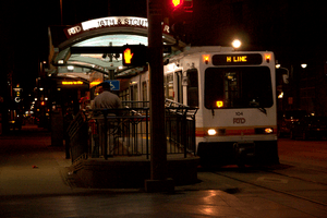
16th & California station and 16th & Stout station are a pair of RTD light rail stations in Downtown Denver, Colorado, United States. Operating as part of the D, F, H, and L lines, the stations were opened on October 8, 1994, and are operated by the Regional Transportation District.[2][3] These stations have one track each, and are one city block apart.[4] 16th & California is served only by northbound trains and 16th & Stout is served only by southbound trains.[4] These stations serve the 16th Street Mall and provide connections to the MallRide shuttle bus and Union Station via the shuttles.
Gallery
 16th & California station
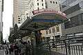 16th & Stout station
References
- 1 2 "Rail Station Activity Analyzed" (PDF). RTD Denver. January 3, 2015. Archived from the original (PDF) on March 20, 2015.
- ↑ Roberts, Jeffrey A. (October 9, 1994). "100,000 give light rail a heavy workout". The Denver Post. p. C1.
- ↑ "RTD: Central Corridor Light Rail Line" (PDF). Regional Transportation District. Archived from the original (PDF) on July 15, 2011. Retrieved September 27, 2010.
- 1 2 "Light rail system map". Regional Transportation District. Archived from the original on 22 September 2010. Retrieved September 26, 2010.
| Operators |
| ||||||||||||
|---|---|---|---|---|---|---|---|---|---|---|---|---|---|
| Rail service |
| ||||||||||||
| Bus service | |||||||||||||
| Other topics | |||||||||||||
This article is issued from
Wikipedia.
The text is licensed under Creative Commons - Attribution - Sharealike.
Additional terms may apply for the media files.