Žirovski Vrh, Žiri
| Žirovski Vrh | |
|---|---|
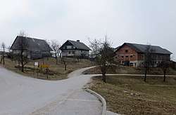 The hamlet of Bukovec in Žirovski Vrh | |
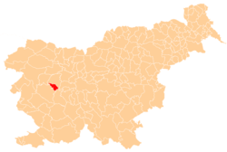
 Žirovski Vrh Location in Slovenia | |
| Coordinates: 46°4′14.28″N 14°7′35.41″E / 46.0706333°N 14.1265028°ECoordinates: 46°4′14.28″N 14°7′35.41″E / 46.0706333°N 14.1265028°E | |
| Country |
|
| Traditional region | Upper Carniola |
| Statistical region | Upper Carniola |
| Municipality | Žiri |
| Area | |
| • Total | 10.98 km2 (4.24 sq mi) |
| Elevation | 714.4 m (2,343.8 ft) |
| Population (2002) | |
| • Total | 240 |
| [1] | |
Žirovski Vrh (pronounced [ʒiˈɾoːu̯ski ˈʋəɾx]) is a dispersed settlement in the hills east of Žiri in the Upper Carniola region of Slovenia. It is made up of isolated farmsteads and small hamlets on the southeastern slopes of a range called Žiri Peak (Slovene: Žirovski vrh).[2] The dispersed nature of the settlement on the hill continues into the neighbouring Municipality of Gorenja Vas–Poljane with the settlements of Žirovski Vrh Svetega Antona and Žirovski Vrh Svetega Urbana on its northern slopes.
References
External links
| Settlements | Administrative centre: Žiri
|  | ||||
|---|---|---|---|---|---|---|
| Landmarks |
| |||||
| Notable people | ||||||
This article is issued from
Wikipedia.
The text is licensed under Creative Commons - Attribution - Sharealike.
Additional terms may apply for the media files.