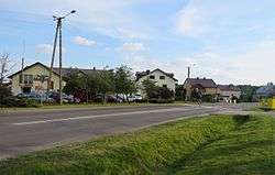
Żabia Wola, Grodzisk Mazowiecki County
| Żabia Wola | |
|---|---|
| Village | |
 | |
 Żabia Wola | |
| Coordinates: 52°1′53″N 20°41′27″E / 52.03139°N 20.69083°E | |
| Country |
|
| Voivodeship | Masovian |
| County | Grodzisk Mazowiecki |
| Gmina | Żabia Wola |
| Elevation | 146 m (479 ft) |
| Population | 530 |
Żabia Wola [ˈʐabja ˈvɔla] is a village in Grodzisk Mazowiecki County, Masovian Voivodeship, in east-central Poland. It is the seat of the gmina (administrative district) called Gmina Żabia Wola.[1] It lies approximately 10 kilometres (6 mi) south-east of Grodzisk Mazowiecki and 30 km (19 mi) south-west of Warsaw.
The village has a population of 530.
References
Coordinates: 52°1′53″N 20°41′27″E / 52.03139°N 20.69083°E
This article is issued from
Wikipedia.
The text is licensed under Creative Commons - Attribution - Sharealike.
Additional terms may apply for the media files.