Šmarjeta pri Celju
| Šmarjeta pri Celju Sveta Marjeta (until 1964) | |
|---|---|
 Šmarjeta pri Celju Location in Slovenia | |
| Coordinates: 46°15′34.79″N 15°17′9.23″E / 46.2596639°N 15.2858972°ECoordinates: 46°15′34.79″N 15°17′9.23″E / 46.2596639°N 15.2858972°E | |
| Country |
|
| Traditional region | Styria |
| Statistical region | Savinja |
| Municipality | Celje |
| Area | |
| • Total | 0.76 km2 (0.29 sq mi) |
| Elevation | 245.6 m (805.8 ft) |
| Population (2002) | |
| • Total | 196 |
| [1] | |
Šmarjeta pri Celju (pronounced [ʃmaˈrjeːta pri ˈtsɛːlju]) is a settlement in the City Municipality of Celje in eastern Slovenia. It lies on the Hudinja River in the northern outskirts of Celje. The area was traditionally part of the Styria region. It is now included with the rest of the municipality in the Savinja Statistical Region.[2]
Name
The name of the settlement was changed from Sveta Marjeta (literally, 'Saint Margaret') to Šmarjeta pri Celju in 1964. The name was changed on the basis of the 1948 Law on Names of Settlements and Designations of Squares, Streets, and Buildings as part of efforts by Slovenia's postwar communist government to remove religious elements from toponyms.[3][4][5]
History
Early settlement of the area is attested by the remains of Roman structures, including a well. The foundation of a wealthier Roman house was discovered on the western edge of the settlement, at Janžek Hill (Slovene: Janžekov grič). In the middle ages, together with neighboring Škofja Vas, Šmarjeta pri Celju was feudal property under the domain of the bishops of Gurk. The territory changed hands several times later. Fichtenhof manor (Slovene: Smrečnik) formerly stood next to the church. The church estate was eventually sold to the convent at Mekinje, then purchased by Dean Jožef von Jakomini (1755–1830) at Nova Cerkev, who in turn sold it in 1802 to nobility living in Slovenske Konjice.[6]
Mass grave
Šmarjeta pri Celju is the site of a mass grave associated with the Second World War. It is part of the 25 mass graves in the Celje area. The Hmezad Mass Grave (Slovene: Grobišče Hmezad) lies about 225 m east of the intersection in the settlement, 125 m east of the bridge across the Hudinja River, where two hop fields are located. The two graves at the site contain the remains of nine German prisoners of war and 10 Russian Cossack prisoners of war, respectively.[7]
References
- ↑ Statistical Office of the Republic of Slovenia
- ↑ Celje municipal site
- ↑ Spremembe naselij 1948–95. 1996. Database. Ljubljana: Geografski inštitut ZRC SAZU, DZS.
- ↑ Premk, F. 2004. Slovenska versko-krščanska terminologija v zemljepisnih imenih in spremembe za čas 1921–1967/68. Besedoslovne lastnosti slovenskega jezika: slovenska zemljepisna imena. Ljubljana: Slavistično društvo Slovenije, pp. 113–132.
- ↑ Urbanc, Mimi, & Matej Gabrovec. 2005. Krajevna imena: poligon za dokazovanje moči in odraz lokalne identitete. Geografski vestnik 77(2): 25–43.
- ↑ Savnik, Roman, ed. 1976. Krajevni leksikon Slovenije, vol. 3. Ljubljana: Državna založba Slovenije. p. 79.
- ↑ Hmezad Mass Grave on Geopedia (in Slovene)
External links
| Administrative center |  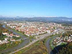 | |
|---|---|---|
| Districts | ||
| Landmarks |
| |
| Local communities |
| |
| Settlements outside the urban center |
| |
| Former settlements |
| |
| Culture | ||
| Notable people |
| |