Řetůvka
| Řetůvka | |||
|---|---|---|---|
| Municipality | |||
 | |||
| |||
 Řetůvka | |||
| Coordinates: 49°57′N 16°21′E / 49.950°N 16.350°ECoordinates: 49°57′N 16°21′E / 49.950°N 16.350°E | |||
| Country |
| ||
| Region | Pardubice | ||
| District | Ústí nad Orlicí | ||
| Area | |||
| • Total | 4.22 km2 (1.63 sq mi) | ||
| Elevation | 380 m (1,250 ft) | ||
| Population (1.1.2013) | |||
| • Total | 282 | ||
| • Density | 67/km2 (170/sq mi) | ||
| Postal code | 561 41 | ||
| Website | http://www.retuvka.cz | ||
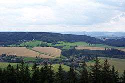
Řetůvka (German: Ritte) is a village and municipality (obec) in the Ústí nad Orlicí District, Pardubice Region of the Czech Republic.
The municipality covers an area of 4.22 square kilometres (1.63 sq mi), and had a population of 265 (as at 2 October 2006).
Řetůvka lies approximately 4 kilometres (2 mi) south-west of Ústí nad Orlicí, 43 km (27 mi) east of Pardubice, and 140 km (87 mi) east of Prague.
References
| Wikimedia Commons has media related to Řetůvka. |
This article is issued from
Wikipedia.
The text is licensed under Creative Commons - Attribution - Sharealike.
Additional terms may apply for the media files.