Ōyano-jima
| Native name: 大矢野島 | |
|---|---|
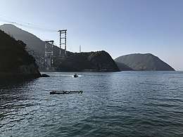 North-eastern part of Ōyanojima and Temmonkyo bridge | |
 Ōyano-jima | |
| Geography | |
| Location | Ariake Sea |
| Coordinates | 32°35′N 130°26′E / 32.583°N 130.433°E [1] |
| Archipelago | Amakusa |
| Area | 29.88 km2 (11.54 sq mi) |
| Length | 8 km (5 mi) |
| Width | 3 km (1.9 mi) |
| Coastline | 55.4 km (34.42 mi) |
| Highest elevation | 229 m (751 ft) |
| Highest point | Tobidake |
| Administration | |
|
Japan | |
| Prefectures | Kumamoto Prefecture |
| City | Kami-Amakusa |
| Demographics | |
| Population | 14,729 (2005) |
| Pop. density | 493 /km2 (1,277 /sq mi) |
| Ethnic groups | Japanese |
Ōyano-jima (南大東島), also spelt as Ōyanojima It is administered as part of the city of Kami-Amakusa. It is connected to the Japanese mainland cince 1966 by Five Bridges of Amakusa.[2] The Japan National Route 266 passes through the island. The island primary industry is aquaculture of fish and shrimps. Large part of island belongs to Unzen-Amakusa National Park.
Geography
Ōyano-jima is a irregular shape, with a ragged, elongated outline oriented at north-south axis. The highest mount is Tobidake (飛岳) which stands at 229 m. Ōyano-jima is the third largest island in the Amakusa group lying west of Kyushu, Japan. It is a northernmost island in the archipelago and serves as a gateway to entire Amakusa.
Climate
Ōyano-jima has a humid subtropical climate (Köppen climate classification Cfa) with very warm summers and mild winters. Precipitation is significant throughout the year; The summer tends to be Ōyano-jima's wettest season, with the tsuyu (梅雨 tsuyu, "plum rain") — the rainy season — occurring between early June (average:Jun.7) to late July (average:Jul.21).
Notable people
- Amakusa Shirō (leader of Shimabara rebellion)
External links
References
- This article incorporates material from Japanese Wikipedia page 大矢野島, accessed 20 September 2018
| Wikimedia Commons has media related to Ōyanojima. |