Łąkta Górna
| Łąkta Górna | |
|---|---|
| Village | |
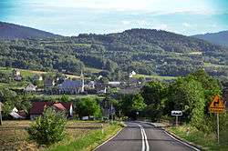 North side view of village | |
 Łąkta Górna | |
| Coordinates: 49°50′N 20°26′E / 49.833°N 20.433°E | |
| Country |
|
| Voivodeship | Lesser Poland |
| County | Bochnia |
| Gmina | Żegocina |
| Elevation | 457 m (1,499 ft) |
| Population [1] | 1,505 |
| Website | www.zegocina.pl (in Polish) |
Łąkta Górna [ˈwɔ̃kta ˈɡurna] is a village and sołectwo in the administrative district of Gmina Żegocina, within Bochnia County, Lesser Poland Voivodeship, in southern Poland.[2] It lies on road number 965, approximately 3.5 kilometres (2 mi) north of Żegocina, 17 km (11 mi) south of Bochnia, and 44 km (27 mi) south-east of the regional capital Kraków.
Łąkta Górna is "Upper Łąkta". The neighbouring village of Łąkta Dolna (Lower Łąkta) is in Gmina Trzciana.
References
- ↑ "Jednostki pomocnicze gminy Żegocina - Sołectwa" [Auxiliary Units of Gmina Żegocina - Sołectwos] (in Polish). Retrieved 7 September 2009.
- ↑ "Central Statistical Office (GUS) - TERYT (National Register of Territorial Land Apportionment Journal)" (in Polish). 1 June 2008.
| Seat |  | |
|---|---|---|
| Other villages | ||
This article is issued from
Wikipedia.
The text is licensed under Creative Commons - Attribution - Sharealike.
Additional terms may apply for the media files.