Łąka, Silesian Voivodeship
| Łąka | ||
|---|---|---|
| Village | ||
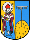
.jpg) Saint Nicholas church | ||
| ||
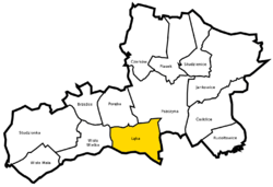 Location of Łąka within Gmina Pszczyna | ||
 Łąka Location of Łąka within Gmina Pszczyna | ||
| Coordinates: 49°58′N 18°55′E / 49.967°N 18.917°ECoordinates: 49°58′N 18°55′E / 49.967°N 18.917°E | ||
| Country |
| |
| Voivodeship | Silesian | |
| County | Pszczyna | |
| Gmina | Pszczyna | |
| Population | 2,690 | |
Łąka [ˈwɔnka] (German Lonkau) is a village in the administrative district of Gmina Pszczyna, within Pszczyna County, Silesian Voivodeship, in southern Poland.[1] It lies approximately 4 kilometres (2 mi) south-west of Pszczyna and 32 km (20 mi) south of the regional capital Katowice.
The village has a population of 2,690.
History
The village was first mentioned in the 14th century.
During the political upheaval caused by Matthias Corvinus the land around Pszczyna was overtaken by Casimir II, Duke of Cieszyn, who sold it in 1517 to the Hungarian magnates of the Thurzó family, forming the Pless state country. In the accompanying sales document issued on 21 February 1517 the village was mentioned as Luka.[2] The Kingdom of Bohemia in 1526 became part of the Habsburg Monarchy. In the War of the Austrian Succession most of Silesia was conquered by the Kingdom of Prussia, including the village.
References
- ↑ "Central Statistical Office (GUS) - TERYT (National Register of Territorial Land Apportionment Journal)" (in Polish). 2008-06-01.
- ↑ Musioł, Ludwik (1930). "Dokument sprzedaży księstwa pszczyńskiego z dn. 21. lutego 1517 R." Roczniki Towarzystwa Przyjaciół Nauk na Śląsku. Katowice: nakł. Towarzystwa ; Drukiem K. Miarki. R. 2: 235–237. Archived from the original on 11 September 2014. Retrieved 12 September 2014.
| Wikimedia Commons has media related to Łąka, Silesian Voivodeship. |
| Town and seat | ||
|---|---|---|
| Villages | ||