Černotín
| Černotín | |||
|---|---|---|---|
| Municipality | |||
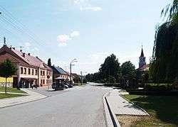 Center of the village | |||
| |||
 Černotín | |||
| Coordinates: 49°32′1″N 17°46′18″E / 49.53361°N 17.77167°ECoordinates: 49°32′1″N 17°46′18″E / 49.53361°N 17.77167°E | |||
| Country |
| ||
| Region | Olomouc | ||
| District | Přerov | ||
| Area | |||
| • Total | 8.31 km2 (3.21 sq mi) | ||
| Elevation | 259 m (850 ft) | ||
| Population (2006) | |||
| • Total | 744 | ||
| • Density | 90/km2 (230/sq mi) | ||
| Postal code | 753 68 | ||
| Website | http://www.cernotin.cz | ||

Černotín is a village and municipality (obec) in Přerov District in the Olomouc Region of the Czech Republic.
The municipality covers an area of 8.31 square kilometres (3.21 sq mi), and has a population of 744 (as at 3 July 2006).
Černotín lies approximately 25 kilometres (16 mi) east of Přerov, 39 km (24 mi) east of Olomouc, and 249 km (155 mi) east of Prague.
References
| Wikimedia Commons has media related to Černotín. |
This article is issued from
Wikipedia.
The text is licensed under Creative Commons - Attribution - Sharealike.
Additional terms may apply for the media files.