Ülenurme Parish
| Ülenurme Parish Ülenurme vald | |||
|---|---|---|---|
| Municipality of Estonia | |||
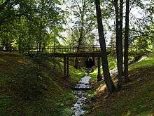
 Porijõgi river | |||
| |||
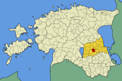 Ülenurme Parish within Tartu County. | |||
| Country |
| ||
| County |
| ||
| Administrative centre | Ülenurme | ||
| Government | |||
| • Mayor | Aivar Aleksejev | ||
| Area | |||
| • Total | 86.35 km2 (33.34 sq mi) | ||
| Population (01.01.2009) | |||
| • Total | 4,773 | ||
| • Density | 55/km2 (140/sq mi) | ||
| Website | www.ylenurme.ee | ||


Ülenurme Parish (Estonian: Ülenurme vald) was a rural municipality in Tartu County, Estonia and was directly south of Tartu.
In 2017 the Government of Estonia (Estonian: Vabariigi Valitsus) decided to merge Ülenurme Parish into Kambja Parish by administrative reform. Ülenurme Parish Council did not wish to voluntarily join, challenging compulsory affiliation to the Supreme Court, but lost their case.[1]
There were four small towns in the rural municipality: Külitse, Räni, Tõrvandi, and Ülenurme. They account for 7/10 of the rural municipality's inhabitants.

Ülenurme got its name from the Ülenurme manor built at the beginning of the 17th century.
Due to the proximity to the city of Tartu, a large-scale real estate development took place in Ülenurme during the economic boom, resulting in the new housing estates of Männi, Aasa and Mõis. Due to this, the number of residents of the village and the Räni has risen rapidly, and they were therefore named small towns in 2013.
The area contains Tartu Airport, where the Estonian Aviation Academy (Estonian: Eesti Lennuakadeemia) operates.
The Tallinn-Tartu-Võru-Luhamaa road, Jõhvi-Tartu-Valga main road, Tartu-Valga railway line, and Tartu-Koidula railway line pass through the area.
The Ilmatsalu River and Pori River flow through the valley located in Ülenurme Parish.
The last Ülenurme Parish governor was Aivar Aleksejev.[2][3]
It had a population of 4,773 (as of 1 January 2009) and covered an area of 86.35 km².[4] The population density is 55.275/km2 (143.162/sq mi).
Settlements
- Small boroughs
Külitse - Räni - Tõrvandi - Ülenurme
- Villages
Laane - Läti - Lemmatsi - Lepiku - Õssu - Reola - Soinaste - Soosilla - Täsvere - Uhti
References
- ↑ Vabariigi Valitsuse 22. juuni 2017. a määruse nr 101 „Kambja valla ja Ülenurme valla osas haldusterritoriaalse korralduse ja Vabariigi Valitsuse 3. aprilli 1995. a määruse nr 159 „Eesti territooriumi haldusüksuste nimistu kinnitamine“ muutmine“ põhiseaduspärasuse kontroll
- ↑ Siseministeerium: Kohalike omavalitsuste juhid 2014. a. jaanuari seisuga, vaadatud 17. oktoober 2014
- ↑ "Vallavalitsus" (in Estonian). Ülenurme vald. Retrieved 20 January 2010.
- ↑ "Population figure and composition". Statistics Estonia. Retrieved 20 January 2010.
External links
| Wikimedia Commons has media related to Ülenurme Parish. |
- Official website (in Estonian)
Coordinates: 58°18′57″N 26°43′27″E / 58.31583°N 26.72417°E
| Urban municipalities | ||
|---|---|---|
| Rural municipalities | ||