Îles de Boynes
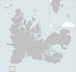 The isles position is highlighted on this Kerguelen Islands map. | |
| Geography | |
|---|---|
| Location | Indian Ocean |
| Coordinates | 50°01′S 68°52′E / 50.017°S 68.867°ECoordinates: 50°01′S 68°52′E / 50.017°S 68.867°E |
| Archipelago | Îles Kerguelen |
| Highest elevation | 35 m (115 ft).[1] |
| Administration | |
|
France | |
| District | Îles Kerguelen |
| Demographics | |
| Population | 0 |
The îles de Boynes, or Boynes Islands, are four small islands of the Kerguelen archipelago, lying some 30 kilometres (19 miles) south of Presqu'ile Rallier du Baty on the main island, just south of the 50 south parallel (50°01′S 68°52′E / 50.017°S 68.867°E). They were discovered in 1772 by the first expedition of Yves-Joseph de Kerguelen-Trémarec. They were named after the marquis de Boynes, the French Secretary of the Navy of the period. Except the disputed claim to Adélie Land, Boynes Islands are the most southerly French land.
References
- ↑ Kerguelen islands map, Géoportail IGN
External links
This article is issued from
Wikipedia.
The text is licensed under Creative Commons - Attribution - Sharealike.
Additional terms may apply for the media files.