Église d'Auteuil (Paris Métro)
Église d'Auteuil | |||||||||||
|---|---|---|---|---|---|---|---|---|---|---|---|
| Paris Métro rapid transit station | |||||||||||
 | |||||||||||
| Location |
Place Théodore Rivière Paris, Île-de-France 75016 | ||||||||||
| Owned by | RATP | ||||||||||
| Line(s) |
| ||||||||||
| Platforms | 1 side platform | ||||||||||
| Tracks | 1 | ||||||||||
| Other information | |||||||||||
| Station code | 0708 | ||||||||||
| History | |||||||||||
| Opened | 30 September 1913 | ||||||||||
| Traffic | |||||||||||
| Passengers (2016) | 172,812 | ||||||||||
| Services | |||||||||||
| |||||||||||
Église d'Auteuil (French pronunciation: [eɡliz doˈtøj], literally Auteuil Church) is a station of the Paris Métro in the 16th arrondissement, serving Line 10 (westbound service only). With around 172,812 passengers in 2016, it is the least-used station on the Paris Métro network.[1]
Location
Église d'Auteuil is located in the neighbourhood of Auteuil, one of the westernmost localities in Paris' city proper. There are two access points: both an entrance and exit are available at the Place de Théodore Rivière, while an exit exists on Rue Wilhem at its intersection with Avenue Théophile Gautier.
History
The station opened on 30 September 1913 as part of the extension of line 8 from Beaugrenelle (now Charles Michels) to Porte d'Auteuil. On 29 July 1937, line 10 was extended from Duroc to La Motte-Picquet - Grenelle and the section of line 8 between La Motte-Picquet - Grenelle and Porte d'Auteuil, including Église d'Auteuil, was transferred to line 10.
This station was named Wilhem until 15 May 1921. Wilhem was the pseudonym of a French musician, Guillaume Louis Bocquillon Wilhem. However, a municipal councillor became convinced that the station was actually named for Kaiser Wilhelm II of Germany, so it was renamed following World War I after a nearby church, Notre-Dame-d'Auteuil.
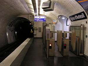
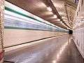
Station layout
| Street Level |
| B1 | Mezzanine |
| Single platform | Side platform, doors will open on the right | |
| Westbound | ← (No service eastbound: Javel – André Citroën) | |
Gallery
| Wikimedia Commons has media related to Église d'Auteuil (Paris Metro). |
References
- Roland, Gérard (2003). Stations de métro. D’Abbesses à Wagram. Éditions Bonneton.
- Notes
- ↑ "Trafic annuel entrant par station du réseau ferré 2016". Open Data RATP.
| Stations |
| ||||||||
|---|---|---|---|---|---|---|---|---|---|
Coordinates: 48°50′50″N 2°16′08″E / 48.847169°N 2.26902°E