Åse, Nordland
| Åse | |
|---|---|
| Village | |
 Åse village museum | |
 Åse Location in Nordland  Åse Åse (Norway) | |
| Coordinates: 69°00′43″N 15°46′13″E / 69.01194°N 15.77028°ECoordinates: 69°00′43″N 15°46′13″E / 69.01194°N 15.77028°E | |
| Country | Norway |
| Region | Northern Norway |
| County | Nordland |
| District | Vesterålen |
| Municipality | Andøy |
| Area[1] | |
| • Total | 0.41 km2 (0.16 sq mi) |
| Elevation[2] | 4 m (13 ft) |
| Population (2013)[1] | |
| • Total | 279 |
| • Density | 680/km2 (1,800/sq mi) |
| Time zone | UTC+01:00 (CET) |
| • Summer (DST) | UTC+02:00 (CEST) |
| Post Code | 8484 Risøyhamn |
Åse is a village in Andøy municipality, Nordland county, Norway. It is located along the Norwegian County Road 82 on the southeastern coast of the island of Andøya, along the Andfjorden. The village of Å lies about 5 kilometres (3.1 mi) to the north, and the villages of Bjørnskinn and Risøyhamn lie about 8 kilometres (5.0 mi) to the southwest. The 0.41-square-kilometre (100-acre) village has a population (2013) of 279, giving the village a population density of 680 inhabitants per square kilometre (1,800/sq mi).[1]
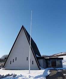
The Baptist church in Åse
References
- 1 2 3 Statistisk sentralbyrå (1 January 2013). "Urban settlements. Population and area, by municipality".
- ↑ "Åse, Andøy" (in Norwegian). yr.no. Retrieved 2012-08-05.
This article is issued from
Wikipedia.
The text is licensed under Creative Commons - Attribution - Sharealike.
Additional terms may apply for the media files.