Äussere Schwarze Schneid
| Äussere Schwarze Schneid | |
|---|---|
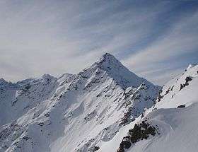 Äussere Schwarze Schneid from the northeast from near the top of the Gaislachkogel. | |
| Highest point | |
| Elevation | 3,257 m (10,686 ft) |
| Prominence | 197 m (646 ft) |
| Isolation | 2.2 kilometres (1.4 mi) |
| Parent peak | Innere Schwarze Schneid |
| Coordinates | 46°56′15″N 10°57′10″E / 46.93750°N 10.95278°ECoordinates: 46°56′15″N 10°57′10″E / 46.93750°N 10.95278°E |
| Geography | |
 Äussere Schwarze Schneid Austria | |
| Location | Tyrol, Austria |
| Parent range | Ötztal Alps |
| Climbing | |
| Easiest route | East ridge (UIAA-I) |
The Äussere Schwarze Schneid is a mountain in the Weisskamm group of the Ötztal Alps.
This article is issued from
Wikipedia.
The text is licensed under Creative Commons - Attribution - Sharealike.
Additional terms may apply for the media files.