Águas Claras, Federal District
| Águas Claras | |
|---|---|
| Administrative region | |
|
Região Administrativa de Águas Claras Administrative Region of Águas Claras | |
.jpg) | |
| Country |
|
| Region | Central-West |
| State |
|
| Founded | April 8, 2003 |
| Government | |
| • Regional administrator | Manoel Valdeci Machado Elias[1] |
| Area | |
| • Total | 31.5 km2 (12.2 sq mi) |
| Population (2010) | |
| • Total | 135.685[2] |
| • Density | 430.7/km2 (1,116/sq mi) |
| Time zone | UTC-3 (UTC-3) |
| • Summer (DST) | UTC-2 (UTC-2) |
| Area code(s) | +55 61 |
| Website | www.aguasclaras.df.gov.br |
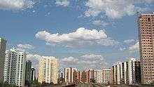
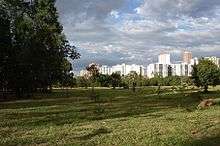
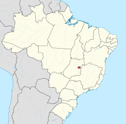
Águas Claras is an administrative region in the Federal District in Brazil.
History
In December 1992, District Law No. 385 authorized the implementation of Águas Claras, then a neighborhood in Taguatinga; its occupation plan was approved later that same year. Designed by architect and urbanist Paulo Zimbres, Águas Claras began construction shortly afterwards. It was separated from Taguatinga as the Federal District's twentieth administrative region on May 6 2003, through District Law No. 3153.
The neighborhood was notable for its accelerated growth, with large and diversified real estate developments.
Águas Claras has an area of approximately 31.5 km² and a population of just over 135 thousand.[2]
Etymology
Its name is reference to the stream within the region which flows into Lake Paranoá.
See also
References
- ↑ "Perfil do administrador" (in Portuguese). Administração Regional de Águas Claras, DF. Retrieved 2015-01-01.
- 1 2 "Pesquisa Distrital por Amostra de Domicílios - 2010/2011" (PDF) (in Portuguese). Codeplan. Retrieved 2013-04-09.
External links
Seat of government: Brasília | ||||||||
|  | |||||||
Coordinates: 15°49′19″S 47°59′36″W / 15.82194°S 47.99333°W