< Fractals < Computer graphic techniques < 2D 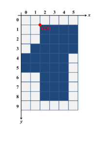

Digital Region Boundary Tracing--start point
The domain has been discretized into a mesh and then rasterized to the image
Image
Digital image
- binary image ( 1-bit color)[1]
- grayscale image
- color image
 binary ( 1 bit) image
 8-bit grayscale image
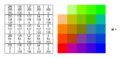 24-bit color image
grid
Dimension
- 2D
- 3D
Elements of polygonal 3D mesh
Types
- regular mesh = Structured grid = global grid ( finite differences)
- An unstructured = irregular grid, adaptive grid, local grid ( fast marching methods)
- Quadtree Grid
- BSP tree
- A triangular surface mesh is always quick and easy to create. It is most common in unstructured grids.
 Basic 2D Cell Shapes
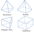 Basic 3D Cell Shapes
tilings by regular polygons: regular (=structured ) grid
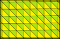 triangular: the Coxeter-Freudenthal triangulation
 quadratic
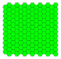 Hexagonal tiling
Pixel connectivity
Pixel connectivity in wikipedia
 Square 4 connectivity
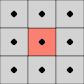 Square 8 connectivity
 Hexagonal 6 connectivity
creating
- gnuplot [6]
coordinate system
In geometry, a coordinate system is a system which uses one or more numbers (= coordinates) to uniquely determine the position of a point in the space[7]
See also
references
- ↑ stackoverflow question: how-can-i-display-a-2d-binary-matrix-as-a-black-white-plot
- ↑ wikipedia: Regular_grid
- ↑ Stuttgart Visualization Course
- ↑ Image Segmentation Using Topologically Adaptable Surfaces by Tim McInerney and Demetri Terzopoulos. Published in the Proc. CVRMed'97, Grenoble, France, March, 1997.
- ↑ T-snakes: Topology adaptive snakes by Tim McInerney , Demetri Terzopoulos. Medical Image Analysis 4 (2000) 73–91
- ↑ gnuplot docs: grid
- ↑ wikipedia : coordinate system
This article is issued from
Wikibooks.
The text is licensed under Creative
Commons - Attribution - Sharealike.
Additional terms may apply for the media files.