Lijst van gemeentelijke monumenten in De Ronde Venen
De gemeente De Ronde Venen telt 100 gemeentelijke monumenten, hieronder een overzicht. Zie ook de rijksmonumenten in De Ronde Venen.
Amstelhoek
De plaats Amstelhoek kent 3 gemeentelijke monumenten:
| Object | Bouwjaar | Architect | Locatie | Coördinaten | Nr. | Afbeelding |
|---|---|---|---|---|---|---|
| Zuivelfabriek | Amstelkade 60 | 52° 13' 57" NB, 4° 50' 8" OL | 0736/wiki1427AN60 | 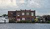 | ||
| Gemaal | Amstelkade 121 | 52° 14' 18" NB, 4° 51' 9" OL | 0736/wiki1427AR121 | Upload foto | ||
| Transformatorhuisje | De Bruinlaan 4 | 52° 13' 49" NB, 4° 50' 9" OL | 0736/wiki1427AH4 | Upload foto |
De Hoef
De plaats De Hoef kent 16 gemeentelijke monumenten:
| Object | Bouwjaar | Architect | Locatie | Coördinaten | Nr. | Afbeelding |
|---|---|---|---|---|---|---|
| T-huis boerderij | Kromme Mijdrecht 10 | 52° 13' 37" NB, 4° 49' 7" OL | 0736/wiki1426AA10 | .jpg) | ||
| T-huis boerderij | Kromme Mijdrecht 18 | 52° 13' 30" NB, 4° 49' 6" OL | 0736/wiki1426AA18 | 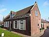 | ||
| Zomerhuis | De Hoef Oostzijde 15 | 52° 12' 33" NB, 4° 48' 52" OL | 0736/wiki1426AE15 | Upload foto | ||
| T-huis boerderij | De Hoef Oostzijde 17-17a | 52° 12' 32" NB, 4° 48' 52" OL | 0736/wiki1426AE17 | Upload foto | ||
| T-huis boerderij 'Spera in Deo' | 1879 | De Hoef Oostzijde 19-20 | 52° 12' 29" NB, 4° 48' 53" OL | 0736/wiki1426AE19 | Upload foto | |
| (school)woning | De Hoef Oostzijde 21 | 52° 12' 27" NB, 4° 48' 55" OL | 0736/wiki1426AE21 | Upload foto | ||
| Voorm.school(lokalen) | De Hoef Oostzijde 22 | 52° 12' 27" NB, 4° 48' 55" OL | 0736/wiki1426AE22 | Upload foto | ||
| RK kerk H.Antonius van Padua | De Hoef Oostzijde 44 | 52° 12' 12" NB, 4° 48' 56" OL | 0736/wiki1426AE44 | 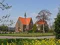 | ||
| Pastorie behorende bij RK kerk | De Hoef Oostzijde 45 | 52° 12' 12" NB, 4° 48' 56" OL | 0736/wiki1426AE45 | | ||
| T-huis boerderij 'Schijn Bedriegt' | De Hoef Oostzijde 115 | 52° 11' 36" NB, 4° 49' 29" OL | 0736/wiki1426AJ115 | Upload foto | ||
| Langhuisboerderij + zomerhuis | Ruigekade 30 | 52° 13' 38" NB, 4° 48' 16" OL | 0736/wiki1426RW30 | Upload foto | ||
| Langhuisboerderij 'De Witte Valk' | Westzijde 11 | 52° 13' 25" NB, 4° 49' 2" OL | 0736/wiki1426AR11 | Upload foto | ||
| Baanwachterswoning | Westzijde 34 | 52° 12' 33" NB, 4° 48' 47" OL | 0736/wiki1426AS34 | Upload foto | ||
| Langhuisboerderij | Westzijde 41 | 52° 12' 19" NB, 4° 48' 53" OL | 0736/wiki1426AT41 | Upload foto | ||
| Langhuisboerderij | Westzijde 47 | 52° 12' 13" NB, 4° 48' 51" OL | 0736/wiki1426AT47 | 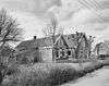 | ||
| T-huis boerderij 'Stroomzicht' | Westzijde 50 | 52° 12' 9" NB, 4° 48' 50" OL | 0736/wiki1426AT50 | Upload foto |
Mijdrecht
De plaats Mijdrecht kent 20 gemeentelijke monumenten:
| Object | Bouwjaar | Architect | Locatie | Coördinaten | Nr. | Afbeelding |
|---|---|---|---|---|---|---|
| Molenstomp | A.C.Verhoefweg 5 | 52° 12' 42" NB, 4° 51' 1" OL | 0736/wiki3643PV5 |  | ||
| Langhuisboerderij | Bozenhoven 4 | 52° 12' 21" NB, 4° 51' 54" OL | 0736/wiki3641AG4 | Upload foto | ||
| Winkel-woonhuis | Bozenhoven 9 | 52° 12' 22" NB, 4° 51' 56" OL | 0736/wiki3641AB9 | Upload foto | ||
| Winkel/woning | Bozenhoven 31+33 | 52° 12' 19" NB, 4° 51' 59" OL | 0736/wiki3641AB31 | Upload foto | ||
| Woning | Bozenhoven 49 | 52° 12' 17" NB, 4° 52' 2" OL | 0736/wiki3641AC49 | Upload foto | ||
| Woning | Bozenhoven 139 | 52° 12' 5" NB, 4° 52' 14" OL | 0736/wiki3641AE139 | Upload foto | ||
| Woning | Bozenhoven 143 | 52° 12' 5" NB, 4° 52' 15" OL | 0736/wiki3641AE143 | Upload foto | ||
| T Oude parochiehuis | Bozenhoven 152 | 52° 12' 1" NB, 4° 52' 20" OL | 0736/wiki3641AJ152 | .jpg) | ||
| T-huis boerderij | Derde Zijweg 7 | 52° 13' 15" NB, 4° 50' 58" OL | 0736/wiki3643PT7 | Upload foto | ||
| (senioren) woningbouwcomplex | Dr. Schaepmanplantsoen 1 t/m 25 | 52° 12' 5" NB, 4° 52' 16" OL | 0736/wiki3641AX1 | Upload foto | ||
| Dwarshuis | Dorpsstraat 8 | 52° 12' 25" NB, 4° 51' 56" OL | 0736/wiki3641EG8 | Upload foto | ||
| Kantoorgebouw 'De Boemerang' | Groot Mijdrechtstraat 81 | 52° 12' 42" NB, 4° 52' 51" OL | 0736/wiki3641RV81 | Upload foto | ||
| Woonhuis annex horeca | Hofland 37 | 52° 12' 41" NB, 4° 52' 4" OL | 0736/wiki3641GA37 | Upload foto | ||
| Complex 16 woningen (3 bouwblokken) | Hoofdweg 8-14 | 52° 12' 21" NB, 4° 51' 44" OL | 0736/wiki3641PS8 | Upload foto | ||
| Complex 16 woningen (3 bouwblokken) | Hoofdweg 16-38 | 52° 12' 20" NB, 4° 51' 43" OL | 0736/wiki3641PS16 | Upload foto | ||
| Transformatorhuisje | Pr.Bernhardlaan nabij 2 (=1) | 0736/wiki3641GP2 | Upload foto | |||
| T-huis boerderij 'Hoeve Mijn Lust' | Ringdijk 2e bedijking 25 | 52° 13' 31" NB, 4° 49' 57" OL | 0736/wiki3641PH25 | Upload foto | ||
| Stationsgebouw | Rondweg 2 | 52° 12' 31" NB, 4° 52' 14" OL | 0736/wiki3641SC2a |  | ||
| Privaatgebouw | Rondweg 2 | 52° 12' 31" NB, 4° 52' 14" OL | 0736/wiki3641SC2b | Upload foto | ||
| Sportzaal-beheerderswoning-garageboxen-vm.winkel | Van Wassenaerstraat 9 | 52° 12' 17" NB, 4° 51' 52" OL | 0736/wiki3641BC9 | Upload foto |
Vinkeveen
De plaats Vinkeveen kent 33 gemeentelijke monumenten:
| Object | Bouwjaar | Architect | Locatie | Coördinaten | Nr. | Afbeelding |
|---|---|---|---|---|---|---|
| Chalet 'De plashoeve' | Baambrugse Zuwe 167 | 52° 14' 16" NB, 4° 58' 11" OL | 0736/wiki3645AG167 | Upload foto | ||
| T-huis boerderij | Demmerik 7-9 | 52° 12' 39" NB, 4° 56' 10" OL | 0736/wiki3645EA7 | Upload foto | ||
| Voorhuis van langhuisboerderij 'Veldwijck | Demmerik 19 | 52° 12' 33" NB, 4° 56' 5" OL | 0736/wiki3645EA19 | Upload foto | ||
| Langhuisboerderij "Spoorzicht" | Demmerik 33 | 52° 12' 26" NB, 4° 56' 3" OL | 0736/wiki3645EA33 | Upload foto | ||
| T-huis boerderij | Demmerik 39 | 52° 12' 22" NB, 4° 55' 60" OL | 0736/wiki3645EA39 | Upload foto | ||
| Langhuisboerderij | Demmerik 65 | 52° 12' 7" NB, 4° 55' 52" OL | 0736/wiki3645EB65 | Upload foto | ||
| Langhuisboerderij | Demmerik 71 | 52° 12' 4" NB, 4° 55' 50" OL | 0736/wiki3645EB71 | Upload foto | ||
| Vm.raadhuis | Demmerik 22 | 52° 12' 43" NB, 4° 56' 9" OL | 0736/wiki3645EC22 | Upload foto | ||
| Landhuis | Demmerik 46 | 52° 12' 38" NB, 4° 56' 5" OL | 0736/wiki3645EC46 | Upload foto | ||
| Langhuisboerderij | Demmerik 47 | 52° 12' 16" NB, 4° 55' 57" OL | 0736/wiki3645EB47 | Upload foto | ||
| Stationsgebouw | Demmerik 68 | 52° 12' 29" NB, 4° 56' 0" OL | 0736/wiki3645ED68 |  | ||
| Langhuisboerderij | Demmeriksekade 9 | 52° 12' 46" NB, 4° 58' 12" OL | 0736/wiki3645AZ9 | Upload foto | ||
| Langhuisboerderij | Donkereind 9 | 52° 11' 52" NB, 4° 55' 44" OL | 0736/wiki3645TC9 | Upload foto | ||
| Langhuisboerderij 'Jacoba's Hoeve' | Donkereind 4 | 52° 11' 51" NB, 4° 55' 41" OL | 0736/wiki3645TD4 | Upload foto | ||
| Woning | Donkereind 12 | 52° 11' 49" NB, 4° 55' 40" OL | 0736/wiki3645TD12 | Upload foto | ||
| Woning 'Sonnehoeck' | Herenweg 23 | 52° 12' 47" NB, 4° 56' 11" OL | 0736/wiki3645DE23 | Upload foto | ||
| Dwarshuisboerderij | Herenweg 52-54 | 52° 12' 52" NB, 4° 56' 11" OL | 0736/wiki3645DR52 | Upload foto | ||
| Langhuisboerderij | Herenweg 58 | 52° 12' 54" NB, 4° 56' 11" OL | 0736/wiki3645DP58 | Upload foto | ||
| Langhuisboerderij | Herenweg 68 | 52° 12' 55" NB, 4° 56' 11" OL | 0736/wiki3645DS68 | Upload foto | ||
| Vrijstaand diep huis | Herenweg 103 | 52° 12' 60" NB, 4° 56' 4" OL | 0736/wiki3645DG103 | Upload foto | ||
| Herenhuis | Herenweg 109-111 | 52° 13' 1" NB, 4° 56' 2" OL | 0736/wiki3645DJ109 |  | ||
| Woning | Herenweg 140 | 52° 13' 1" NB, 4° 56' 6" OL | 0736/wiki3645DT140 | Upload foto | ||
| Villa | Herenweg 142 | 52° 13' 1" NB, 4° 56' 6" OL | 0736/wiki3645DT142 | Upload foto | ||
| Woonhuis-winkel-werkplaats | Herenweg 175-177 | 52° 13' 9" NB, 4° 55' 57" OL | 0736/wiki3645DK175 | Upload foto | ||
| Pastorie behorende bij PKN | Herenweg 203 | 52° 13' 12" NB, 4° 55' 55" OL | 0736/wiki3645DL203 | Upload foto | ||
| Woning | Herenweg 221 | 52° 13' 15" NB, 4° 55' 52" OL | 0736/wiki3645DL221 | Upload foto | ||
| Geref.kerk (PKN) | Herenweg 253 | 52° 13' 17" NB, 4° 55' 49" OL | 0736/wiki3645DM253 | Upload foto | ||
| Woning | Herenweg 206 | 52° 13' 11" NB, 4° 55' 59" OL | 0736/wiki3645DV206 | Upload foto | ||
| Dubbel Herenhuis | Herenweg 230-232-234 | 52° 13' 17" NB, 4° 55' 54" OL | 0736/wiki3645DW230 | Upload foto | ||
| Herenhuis | Herenweg 230-232-234 | 52° 13' 17" NB, 4° 55' 54" OL | 0736/wiki3645DW234 | Upload foto | ||
| Middenstandswoningen | Kerklaan 5-7-9 | 52° 14' 48" NB, 4° 59' 20" OL | 0736/wiki3645ES5 | Upload foto | ||
| Patronaatsgebouw | Kerklaan 18 | 52° 12' 52" NB, 4° 55' 54" OL | 0736/wiki3645EV18 | Upload foto | ||
| (helft) dubbele baanwachterswoning; afgebroken helft is in dezelfde stijl opgetrokken | Ringdijk 6 | 52° 12' 26" NB, 4° 55' 41" OL | 0736/wiki3645HG6 | Upload foto |
Waverveen
De plaats Waverveen kent 4 gemeentelijke monumenten:
| Object | Bouwjaar | Architect | Locatie | Coördinaten | Nr. | Afbeelding |
|---|---|---|---|---|---|---|
| Kringenwetwoning (hout) | Botsholsedwarsweg 14 | 52° 14' 38" NB, 4° 52' 20" OL | 0736/wiki3646AK14 | Upload foto | ||
| Onderwijzerswoning | Hoofdweg 8 | 52° 14' 37" NB, 4° 54' 12" OL | 0736/wiki3646AX8 | Upload foto | ||
| Herenhuis | Nessersluis 18 | 52° 14' 57" NB, 4° 51' 51" OL | 0736/wiki3646AD18 | Upload foto | ||
| Schotbalkenkering | Nessersluis ong. | 0736/wiki1 | 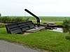 | |||
| Grenspaal, vroegere grens Utrecht en Holland | Poeldijk bij 4 | 52° 13' 15" NB, 4° 53' 4" OL | 0736/ | .jpg) |
Wilnis
De plaats Wilnis kent 24 gemeentelijke monumenten:
| Object | Bouwjaar | Architect | Locatie | Coördinaten | Nr. | Afbeelding |
|---|---|---|---|---|---|---|
| Langhuisboerderij 'Amstelzicht | Amstelkade 49 | 52° 10' 26" NB, 4° 52' 1" OL | 0736/wiki3648KA49 | Upload foto | ||
| Zomerhuis | Amstelkade 59 | 52° 10' 34" NB, 4° 51' 48" OL | 0736/wiki3648KA59 | Upload foto | ||
| T-huis boerderij 'Bethlehem' | Amstelkade 61 | 52° 10' 33" NB, 4° 51' 48" OL | 0736/wiki3648KA61 | Upload foto | ||
| Molenstomp 'Driehuizermolen' | Amstelkade 72 | 52° 10' 52" NB, 4° 50' 38" OL | 0736/wiki3648KA72 | Upload foto | ||
| Langhuisboerderij | Dorpsstraat 38 | 52° 11' 42" NB, 4° 54' 15" OL | 0736/wiki3648AH38 | Upload foto | ||
| (dwarshuis) woning | Dorpsstraat 42 | 52° 11' 43" NB, 4° 54' 16" OL | 0736/wiki3648AH42 | Upload foto | ||
| (post)kantoor/huis | Dorpsstraat 59 | 52° 11' 44" NB, 4° 54' 17" OL | 0736/wiki3648AG59 | Upload foto | ||
| (veldwachters)woning | Dorpsstraat 61 | 52° 11' 44" NB, 4° 54' 18" OL | 0736/wiki3648AG61 | Upload foto | ||
| (langhuis)woning | Dorpsstraat 72 | 52° 11' 43" NB, 4° 54' 18" OL | 0736/wiki3648AJ72 | Upload foto | ||
| Winkel/woning | Dorpsstraat 74 | 52° 11' 43" NB, 4° 54' 19" OL | 0736/wiki3648AJ74 | Upload foto | ||
| (sluiswachters)woning | Geerkade 53 | 52° 10' 7" NB, 4° 55' 42" OL | 0736/wiki3648NX53 | Upload foto | ||
| Dwarshuisboerderij | Herenweg 2-4 | 52° 11' 42" NB, 4° 54' 4" OL | 0736/wiki3648CJ2 | Upload foto | ||
| Woning | Herenweg 269 | 52° 11' 56" NB, 4° 52' 34" OL | 0736/wiki3648CH269 | Upload foto | ||
| Stationsgebouw | Ir.Enschedeweg 14 | 0736/wiki3648BV14 | Upload foto | |||
| Langhuisboerderij | Mijdr.dwarsweg 5 | 0736/wiki3678BR5 | Upload foto | |||
| Langhuisboerderij 'Veenlust' | Oudhuijzerweg 2-2a | 52° 11' 42" NB, 4° 54' 23" OL | 0736/wiki3648AC2 | Upload foto | ||
| Langhuisboerderij 'Ijda's hoeve' | Oudhuijzerweg 18 | 52° 11' 43" NB, 4° 54' 30" OL | 0736/wiki3648AC18 | Upload foto | ||
| T-huis boerderij 'Eykelhoeve' | Oudhuijzerweg 24 | 52° 11' 43" NB, 4° 54' 32" OL | 0736/wiki3648AC24 | 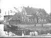 | ||
| T-huis boerderij | Oudhuijzerweg 28 | 52° 11' 44" NB, 4° 54' 37" OL | 0736/wiki3648AC28 | Upload foto | ||
| Raadhuis | Raadhuisstraat 1 | 52° 11' 44" NB, 4° 54' 10" OL | 0736/wiki3648AR1 | Upload foto | ||
| Woonhuis (voormalig pakhuis) | Stationsweg 2-4 | 52° 11' 43" NB, 4° 54' 16" OL | 0736/wiki3648AN2 | Upload foto | ||
| Langhuisboerderij | Veldhuisweg 1 | 52° 11' 15" NB, 4° 55' 58" OL | 0736/wiki3648AX1 | Upload foto | ||
| Langhuisboerderij | Wilnisse Zuwe 34 | 52° 10' 19" NB, 4° 54' 8" OL | 0736/wiki3648NL34 | Upload foto | ||
| Langhuisboerderij 'Lucie Hoeve' | Wilnisse Zuwe 35 | 52° 10' 16" NB, 4° 54' 10" OL | 0736/wiki3648NK35 | Upload foto |
| Zie de categorie Gemeentelijke monumenten in De Ronde Venen van Wikimedia Commons voor mediabestanden over dit onderwerp. |
| Bron |
This article is issued from
Wikipedia.
The text is licensed under Creative
Commons - Attribution - Sharealike.
Additional terms may apply for the media files.