Lijst van gemeentelijke monumenten in Terborg
De plaats Terborg, onderdeel van de gemeente Oude IJsselstreek, kent 26 gemeentelijke monumenten:
| Object | Bouwjaar | Architect | Locatie | Coördinaten | Nr. | Afbeelding |
|---|---|---|---|---|---|---|
| Richtershuis | Doetinchemseweg 6-8 | 51° 55' 15" NB, 6° 21' 43" OL | 1509/129 | 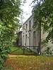 | ||
| Dubbel woonhuis met looierij | Doetinchemseweg 45-47 | 51° 55' 22" NB, 6° 21' 39" OL | 1509/130 |  | ||
| Woonhuis | Ettensestraat 17 | 51° 55' 2" NB, 6° 21' 2" OL | 1509/131 | 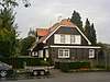 | ||
| Woonhuis | Ettensestraat 36 | 51° 55' 5" NB, 6° 21' 7" OL | 1509/132 | 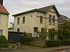 | ||
| Georgiuskerk | 1913-1914 | Jan Stuyt | Hoofdstraat 73 | 51° 55' 9" NB, 6° 21' 27" OL | 1509/133 | 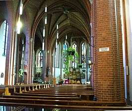 |
| Woonhuis | Hoofdstraat 83 | 51° 55' 8" NB, 6° 21' 25" OL | 1509/134 | 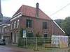 | ||
| Pakhuisgeveltje/ huis Deurvorst | Laan van Wisch 1/Hoofdstraat 89 | 51° 55' 8" NB, 6° 21' 23" OL | 1509/135 | _-_3.jpg) | ||
| Woonhuis | Hoofdstraat 94-96 | 51° 55' 9" NB, 6° 21' 21" OL | 1509/136 |  | ||
| Kantoor Waterschap | Hoofdstraat 98 | 51° 55' 9" NB, 6° 21' 20" OL | 1509/137 | 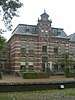 | ||
| Voormalige Vakschool voor meisjes Wisch | Hoofdstraat 100 | 51° 55' 9" NB, 6° 21' 19" OL | 1509/138 | 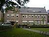 | ||
| Dubbel woonhuis | Looiersweg 10-12 | 51° 55' 15" NB, 6° 21' 48" OL | 1509/139 | 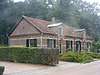 | ||
| Villa De Paaschberg | Paasberglaan 7 | 51° 55' 3" NB, 6° 21' 56" OL | 1509/140 | 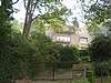 | ||
| Oude postkantoor | Silvoldseweg 3-5-7 | 51° 55' 11" NB, 6° 21' 46" OL | 1509/141 | 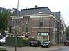 | ||
| Kantongerecht | 1896 | Willem Metzelaar | Silvoldseweg 10 | 51° 55' 10" NB, 6° 21' 56" OL | 1509/142 | 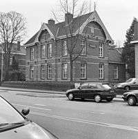 |
| Woonhuis Knies | Silvoldseweg 12 | 51° 55' 9" NB, 6° 21' 57" OL | 1509/143 | 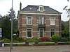 | ||
| Herenhuis Sorgedrager | Silvoldseweg 19 | 51° 55' 11" NB, 6° 21' 54" OL | 1509/144 | 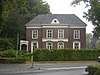 | ||
| Vml. Villa | Silvoldseweg 27 | 51° 55' 10" NB, 6° 22' 0" OL | 1509/145 | 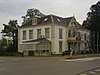 | ||
| Begraafcomplex | Silvoldseweg 64 | 51° 55' 2" NB, 6° 22' 19" OL | 1509/146 | 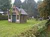 | ||
| PTT-gebouw | Sint Jorisplein 1 | 51° 55' 11" NB, 6° 21' 42" OL | 1509/147 | 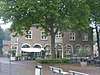 | ||
| Vml. Brandspuithuisje | Sint Jorisstraat 1 | 51° 55' 10" NB, 6° 21' 41" OL | 1509/148 | 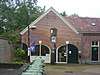 | ||
| Gasthuiswoningen | Sint Jorisstraat 3-11 | 51° 55' 10" NB, 6° 21' 40" OL | 1509/149 | 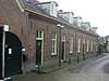 | ||
| Kantoorpand | Sint Jorisplein 12 | 51° 55' 12" NB, 6° 21' 40" OL | 1509/150 | 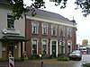 | ||
| De Roode Leeuw | Sint Jorisplein 14 | 51° 55' 12" NB, 6° 21' 43" OL | 1509/151 | 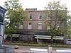 | ||
| Villa De Beijenhof | Stationsweg 1 | 51° 55' 20" NB, 6° 21' 41" OL | 1509/152 | 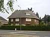 | ||
| Stationsgebouw | 1885 | Stationsweg 25 | 51° 55' 21" NB, 6° 21' 50" OL | 1509/153 | 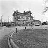 | |
| Schoolgebouw | Walstraat 22 | 51° 55' 13" NB, 6° 21' 33" OL | 1509/154 | 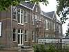 |
Zie ook
| Zie de categorie Gemeentelijke monumenten in Terborg van Wikimedia Commons voor mediabestanden over dit onderwerp. |
| Bronnen, noten en/of referenties
|
This article is issued from
Wikipedia.
The text is licensed under Creative
Commons - Attribution - Sharealike.
Additional terms may apply for the media files.