Lijst van gemeentelijke monumenten in Roerdalen
De gemeente Roerdalen heeft 106 gemeentelijke monumenten, hieronder een overzicht. Zie ook de rijksmonumenten in Roerdalen.
Herkenbosch
De plaats Herkenbosch kent 19 gemeentelijke monumenten:
| Object | Bouwjaar | Architect | Locatie | Coördinaten | Nr. | Afbeelding |
|---|---|---|---|---|---|---|
| Wegkruis | Aan de Vier Gebroeders/Schaapsweg | 51° 9' 17" NB, 6° 3' 22" OL | 1669/WN001 | Upload foto | ||
| Woonhuis | Daelenbroekweg 15 | 51° 9' 16" NB, 6° 4' 5" OL | 1669/WN002 | Upload foto | ||
| Boerderijhoeve | Dr. Biermansstraat 17 | 51° 9' 10" NB, 6° 3' 32" OL | 1669/WN003 | Upload foto | ||
| Wegkruis | Dr. Biermansstraat/splitsing Hammerstraat | 51° 9' 10" NB, 6° 3' 38" OL | 1669/WN004 | _wegkruis_Dr._Biermansstraat.JPG) | ||
| Woonhuis in Traditionalisme stijl | XIXd | Hammerstraat 17 | 51° 9' 6" NB, 6° 3' 34" OL | 1669/WN005 |  | |
| Boerderijhoeve | Hammerstraat 23 | 51° 9' 5" NB, 6° 3' 31" OL | 1669/WN006 | Upload foto | ||
| Woonhuis | Hammerstraat 24 | 51° 9' 5" NB, 6° 3' 27" OL | 1669/WN007 |  | ||
| Woonhuis in 19e-eeuws traditioneel stijl | 1894 | Hoofdstraat 2 | 51° 9' 10" NB, 6° 3' 41" OL | 1669/WN008 | 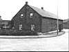 | |
| Beeld | Hoofdstraat bij 18, in plantsoen tegenover H. Hartbeeld | 51° 9' 11" NB, 6° 3' 48" OL | 1669/WN009 | Upload foto | ||
| Grafkruisen Hardstenen grijs Achter koor St. Sebastianuskerk | Hoofdstraat 21 | 51° 9' 11" NB, 6° 3' 48" OL | 1669/WN010 | Upload foto | ||
| Wegkruis | Meinweg 223 (naastgelegen) | 51° 11' 12" NB, 6° 10' 47" OL | 1669/WN011 | Upload foto | ||
| Hammerhof | Muytertweg 33 | 51° 9' 7" NB, 6° 2' 40" OL | 1669/WN012 | Upload foto | ||
| Wegkruis | Driesprong Muytertweg/Waterschei/Hammerlaan | 51° 8' 55" NB, 6° 4' 13" OL | 1669/WN013 | _Hammerhofkruis.JPG) | ||
| Wegkruis | Stationsweg 2, ervoor | 51° 8' 15" NB, 6° 6' 31" OL | 1669/WN014 | _wegkruis_stationsweg.JPG) | ||
| Woonhuis/kantoor in Traditionalisme stijl | ca. 1900[1] | Stationsweg 53 | 51° 9' 28" NB, 6° 4' 0" OL | 1669/WN015 | Upload foto | |
| Woonhuis | Steegstraat 4 | 51° 9' 9" NB, 6° 3' 42" OL | 1669/WN016 | 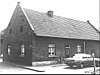 | ||
| Groot gebouwencomplex De Steeg | Steegstraat 10 | 51° 9' 8" NB, 6° 3' 46" OL | 1669/WN017 |  | ||
| O.L. Vrouwe van Fatima Kapel | Wijngaardstraat 5 | 51° 9' 46" NB, 6° 3' 39" OL | 1669/WN018 | Upload foto | ||
| Wit kapelletje voor Fatimakapel | Wijngaardstraat 5 | 51° 9' 46" NB, 6° 3' 39" OL | 1669/WN019 | Upload foto |
Melick
De plaats Melick kent 22 gemeentelijke monumenten:
| Object | Bouwjaar | Architect | Locatie | Coördinaten | Nr. | Afbeelding |
|---|---|---|---|---|---|---|
| Woonhuis | De steeg 9 | 51° 9' 22" NB, 6° 1' 8" OL | 1669/WN020 | Upload foto | ||
| Boerderij/hoeve in Traditionalisme stijl | ca 1905 | Dorpsstraat 23 | 51° 9' 24" NB, 6° 0' 40" OL | 1669/WN021 | Upload foto | |
| Oud raadhuis | 1888, 1919 verbouwd[2] |
Dorpsstraat 43 | 51° 9' 26" NB, 6° 0' 52" OL | 1669/WN022 | Upload foto | |
| Woonhuis in Traditionalisme stijl | 1922 | Dorpsstraat 51 | 51° 9' 26" NB, 6° 0' 55" OL | 1669/WN023 | Upload foto | |
| Boerderij/Hoeve Genhof | Dorpsstraat 96 | 51° 9' 26" NB, 6° 1' 9" OL | 1669/WN024 | Upload foto | ||
| Wegkruis | Dr. Nolenslaan/Clauslaan | 51° 9' 38" NB, 6° 0' 50" OL | 1669/WN025 | Upload foto | ||
| Woonhuis Hoeve Milling in Traditionalisme stijl | ca 1924 | Groenstraat 12 | 51° 9' 29" NB, 6° 1' 15" OL | 1669/WN026 | Upload foto | |
| Woonhuis in Traditionalisme stijl | ca 1907 | Groenstraat 26 | 51° 9' 30" NB, 6° 1' 22" OL | 1669/WN027 | Upload foto | |
| Boerderij/hoeve in Traditionalisme stijl | 1917 | Groenstraat 32 | 51° 9' 31" NB, 6° 1' 24" OL | 1669/WN028 | 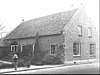 | |
| Boerderij/hoeve in 19e-eeuws traditioneel stijl | XIXd | Groenstraat 34 | 51° 9' 31" NB, 6° 1' 26" OL | 1669/WN029 | Upload foto | |
| Boerderij/hoeve | Groenstraat 54 | 51° 9' 35" NB, 6° 1' 35" OL | 1669/WN030 | 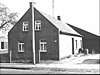 | ||
| Boerderij/hoeve Lattenhof in Traditionalisme stijl | ca 1905 | Heinsbergerweg 40 | 51° 9' 23" NB, 6° 0' 27" OL | 1669/WN031 | Upload foto | |
| Mariakapel | Heinsbergerweg tov Dorpsstraat | 51° 9' 22" NB, 6° 0' 27" OL | 1669/WN032 | Upload foto | ||
| Apolloniabeeld | Kerkberg (Oud kerkhof) | 51° 9' 22" NB, 6° 0' 23" OL | 1669/WN033 | Upload foto | ||
| Bionenburg | Kerkberg (Oud kerkhof) | 51° 9' 22" NB, 6° 0' 23" OL | 1669/WN034 | Upload foto | ||
| De Schilling | Kerkberg (Oud kerkhof) | 51° 9' 22" NB, 6° 0' 23" OL | 1669/WN035 | Upload foto | ||
| Grafkruis Bolch | Kerkberg (Oud kerkhof) | 51° 9' 22" NB, 6° 0' 23" OL | 1669/WN036 | Upload foto | ||
| Grafkruis Plumechers | Kerkberg (Oud kerkhof) | 51° 9' 22" NB, 6° 0' 23" OL | 1669/WN037 | Upload foto | ||
| Grafmonument pastoor Bartels | Kerkberg (Oud kerkhof) | 51° 9' 22" NB, 6° 0' 23" OL | 1669/WN038 | Upload foto | ||
| Paulusbeeld | Kerkberg (Oud kerkhof) | 51° 9' 22" NB, 6° 0' 23" OL | 1669/WN039 | Upload foto | ||
| Woonhuis | Waterschei 22 | 51° 9' 31" NB, 6° 1' 56" OL | 1669/WN040 | Upload foto | ||
| Beeld De Verrezen Christus | Waterschei/hoek Groenstraat | 51° 9' 35" NB, 6° 1' 54" OL | 1669/WN041 | Upload foto |
Montfort
De plaats Montfort kent 2 gemeentelijke monumenten:
| Object | Bouwjaar | Architect | Locatie | Coördinaten | Nr. | Afbeelding |
|---|---|---|---|---|---|---|
| Voormalig schoolgebouw, thans klooster in Traditionalisme stijl | ca 1910 | Kerkstraat 1-3 | 51° 7' 32" NB, 5° 56' 50" OL | 1669/WN042 | 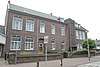 | |
| Voormalige boerderij, nu woonhuis in Traditionalisme stijl | XXa | Vinkesteeg 1 | 51° 7' 29" NB, 5° 57' 8" OL | 1669/WN043 | 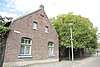 |
Posterholt
De plaats Posterholt kent 3 gemeentelijke monumenten:
| Object | Bouwjaar | Architect | Locatie | Coördinaten | Nr. | Afbeelding |
|---|---|---|---|---|---|---|
| Voormalige boerdeij, nu woonhuis | vroeg-19de-eeuws[3] | Burg. Geradtsstraat 16 | 51° 7' 39" NB, 6° 1' 18" OL | 1669/WN044 |  | |
| Gesloten hoeve met woonhuis Borgshof[3] | 1913 | Heinsbergerweg 56 | 51° 6' 50" NB, 6° 2' 50" OL | 1669/WN045 | 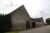 | |
| Trafohuis | 1935[3] | Roermondseweg naast 1 | 51° 7' 36" NB, 6° 1' 25" OL | 1669/WN046 | 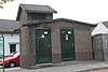 |
St. Odiliënberg
De plaats St. Odiliënberg kent 3 gemeentelijke monumenten:
| Object | Bouwjaar | Architect | Locatie | Coördinaten | Nr. | Afbeelding |
|---|---|---|---|---|---|---|
| Voormalig postkantoor in Traditionalisme met invloeden van Jugendstil stijl[4] | 1910 | Hoofdstraat 11 | 51° 8' 48" NB, 6° 0' 12" OL | 1669/WN047 |  | |
| Pastorie in Invloed van Neorenaissance stijl | ca 1885 | Hoofdstraat 22 | 51° 8' 47" NB, 6° 0' 12" OL | 1669/WN048 | 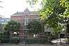 | |
| Woonhuis in Traditionalisme stijl | ca 1920 | Pastoor Siebenstraat 5 | 51° 8' 50" NB, 6° 0' 9" OL | 1669/WN049 | 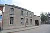 |
Vlodrop
De plaats Vlodrop kent 57 gemeentelijke monumenten:
| Object | Bouwjaar | Architect | Locatie | Coördinaten | Nr. | Afbeelding |
|---|---|---|---|---|---|---|
| Grafkruis Wolfhagen | Angsterweg Begraafplaats | 51° 7' 48" NB, 6° 4' 25" OL | 1669/WN050 | Upload foto | ||
| Woonhuis in Traditionalisme stijl | 1917 | Bennebroekweg 10 | 51° 8' 6" NB, 6° 4' 21" OL | 1669/WN051 | Upload foto | |
| Boerderij/hoeve in 19e-eeuws traditioneel stijl | XIXB | Bergerweg 7 | 51° 7' 57" NB, 6° 4' 35" OL | 1669/WN052 | Upload foto | |
| Woonhuis in Traditionalisme stijl | ca 1930 | Bergerweg 9 | 51° 7' 57" NB, 6° 4' 35" OL | 1669/WN053 | Upload foto | |
| Boerderij/hoeve in 19e-eeuws traditioneel stijl | Eind 18de eeuw[5] | Bergerweg 17 | 51° 7' 59" NB, 6° 4' 32" OL | 1669/WN054 | Upload foto | |
| Woonhuis in Traditionalisme stijl | 1924 | Bergerweg 29-31 | 51° 8' 2" NB, 6° 4' 24" OL | 1669/WN055 | Upload foto | |
| Woonhuis in 19e-eeuws traditioneel stijl | 1896 | Bergerweg 30 | 51° 8' 3" NB, 6° 4' 26" OL | 1669/WN056 | Upload foto | |
| Woonhuis Huize Helena in Traditionalisme stijl | 1930 | Henderix, Jac. te Roermond. | Bergerweg 38 | 51° 8' 6" NB, 6° 4' 18" OL | 1669/WN057 | Upload foto |
| Boerderij/hoeve De Triest | Bergerweg 46 | 51° 8' 30" NB, 6° 3' 37" OL | 1669/WN058 | Upload foto | ||
| Woonhuis in Traditionalisme stijl | 1930 | Wagemans, W. te Roggel. | Bergerweg 47 | 51° 8' 5" NB, 6° 4' 16" OL | 1669/WN059 | Upload foto |
| Boerderij/hoeve Moorsel in 19e-eeuws traditioneel stijl | begin-19de-eeuws | Bergerweg 48 | 51° 8' 28" NB, 6° 2' 52" OL | 1669/WN060 | 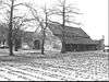 | |
| Veldkruis de Triest | Bergerweg (nabij Hoeve triest) | 51° 8' 30" NB, 6° 3' 36" OL | 1669/WN061 | Upload foto | ||
| Wegkruis | Bergerweg/Randweg | 51° 8' 2" NB, 6° 4' 28" OL | 1669/WN062 | Upload foto | ||
| Wegkruis | Bergerweg/Walstraat | 51° 7' 57" NB, 6° 4' 37" OL | 1669/WN063 | Upload foto | ||
| Boerderij/hoeve | Boomgaardstraat 12-14 | 51° 7' 52" NB, 6° 4' 46" OL | 1669/WN064 | Upload foto | ||
| Boerderij/hoeve in Traditionalisme stijl | 1933 | Beckers, J.W. Vlodrop | Etsberg 12 | 51° 8' 16" NB, 6° 5' 38" OL | 1669/WN065 | Upload foto |
| Boerderij/hoeve | Etsberg 26 | 51° 8' 15" NB, 6° 5' 45" OL | 1669/WN066 | Upload foto | ||
| Wegkruis | Etsberg | 51° 7' 35" NB, 6° 4' 39" OL | 1669/WN067 | _wegkruis_in_centrum.JPG) | ||
| Schuur bij Gitstappermolen | 1750[5] | Gitstappermolenweg bij 1 | 51° 8' 16" NB, 6° 6' 31" OL | 1669/WN068 | Upload foto | |
| Boerderij/hoeve in Traditionalisme stijl | 1904 | Grootestraat 15 | 51° 7' 57" NB, 6° 4' 44" OL | 1669/WN069 | Upload foto | |
| Boerderij/hoeve in 19e-eeuws traditioneel stijl | XIXB | Grootestraat 21 | 51° 7' 57" NB, 6° 4' 46" OL | 1669/WN070 | Upload foto | |
| Boerderij/hoeve | Grootestraat 24 | 51° 7' 58" NB, 6° 4' 49" OL | 1669/WN071 | Upload foto | ||
| Boerderij/hoeve in 19e-eeuws traditioneel stijl | XIXB | Grootestraat 29 | 51° 7' 59" NB, 6° 4' 47" OL | 1669/WN072 | Upload foto | |
| Boerderij/hoeve | Grootestraat 49 | 51° 8' 3" NB, 6° 4' 51" OL | 1669/WN073 | Upload foto | ||
| Wegkruis | Grootestraat tov Steinwinkelweg | 51° 7' 59" NB, 6° 4' 50" OL | 1669/WN074 | Upload foto | ||
| Grenskantoor | Herkenbosserweg 7-9 | 51° 8' 28" NB, 6° 7' 6" OL | 1669/WN075 | Upload foto | ||
| Herdenkingsmonument Dr. Meuwissen[6] | Herkenbosserweg/Boslaan | 51° 8' 38" NB, 6° 6' 11" OL | 1669/WN076 | Upload foto | ||
| Wegkruis Vagevuur | Holsterweg (Schutterslokaal) | 51° 8' 7" NB, 6° 3' 8" OL | 1669/WN077 | Upload foto | ||
| kasteelboerderij Huyserhof | 1854[5] | Kasteelweg 3 | 51° 7' 50" NB, 6° 4' 42" OL | 1669/WN078 |  | |
| Mariakapel | 1996[7] | Kerkbergweg 1 | 51° 7' 48" NB, 6° 4' 36" OL | 1669/WN079 | .JPG) | |
| Kerkhofkruis | Kerkbergweg 2 (bij fam. Van Helden) | 51° 7' 35" NB, 6° 4' 39" OL | 1669/WN080 | _wegkruis_Kerkbergweg.JPG) | ||
| Boerderij Rentelaershof | begin 19e-eeuw[5] | Kerkbergweg 3 | 51° 7' 31" NB, 6° 4' 44" OL | 1669/WN081 | Upload foto | |
| Woonhuis in Traditionalisme stijl | 1916 | Kerkstraat 3-5 | 51° 7' 53" NB, 6° 4' 32" OL | 1669/WN082 | Upload foto | |
| Woonhuis in Traditionalisme stijl | 1923 | Kerkstraat 4 | 51° 7' 54" NB, 6° 4' 31" OL | 1669/WN083 | Upload foto | |
| Gehele begraafplaats incl. muur, poorten, grafmonumenten, voormalige sacristie. | Kerkstraat 7 | 51° 7' 53" NB, 6° 4' 30" OL | 1669/WN084 | Upload foto | ||
| Boerderij/hoeve | Kerkstraat 14 | 51° 7' 53" NB, 6° 4' 28" OL | 1669/WN085 | Upload foto | ||
| Boerderij/hoeve in 19e-eeuws traditioneel stijl | 1898 | Kerkstraat 16 | 51° 7' 53" NB, 6° 4' 28" OL | 1669/WN086 | Upload foto | |
| Graftombe/zerk Scherpenzeel - Heusch | Kerkstraat | 51° 7' 53" NB, 6° 4' 30" OL | 1669/WN087 | Upload foto | ||
| St. Franciscusbeeld | Kerkstraat, plantsoen | 51° 7' 53" NB, 6° 4' 32" OL | 1669/WN088 | _beeld_Sint_Franciscus_Xaverius.jpg) | ||
| Boerderij/hoeve in Traditionalisme stijl | 1920 | Kleine Wal 10 | 51° 7' 55" NB, 6° 4' 35" OL | 1669/WN089 | Upload foto | |
| Woonhuis Achter de staldeur | Kleine Wal 12 | 51° 7' 56" NB, 6° 4' 36" OL | 1669/WN090 | Upload foto | ||
| Woonhuis in 19e-eeuws traditioneel stijl | XIXd | Klifsbergweg 3 | 51° 8' 16" NB, 6° 5' 17" OL | 1669/WN091 | Upload foto | |
| Wegkruis de Kievit (geen wegkruis gevonden) | Klifsbergweg 22 bij (Tankstation) | 51° 8' 36" NB, 6° 6' 12" OL | 1669/WN092 | Upload foto | ||
| Voormalig gemeentehuis in Traditionalisme stijl | 1929, 1950 verbouwd |
J. Bongaerts[5] | Markt 1 | 51° 7' 54" NB, 6° 4' 37" OL | 1669/WN093 | 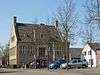 |
| Woonhuis De Lindeboom | Markt 18 | 51° 7' 56" NB, 6° 4' 42" OL | 1669/WN094 | Upload foto | ||
| Boerderij/hoeve | Markt 22-22a | 51° 7' 54" NB, 6° 4' 35" OL | 1669/WN095 | Upload foto | ||
| Wegkruis | Markt | 51° 7' 54" NB, 6° 4' 38" OL | 1669/WN096 | Upload foto | ||
| Woonhuis | Martinusweg 7 | 51° 7' 58" NB, 6° 4' 30" OL | 1669/WN097 | Upload foto | ||
| Marechausseekazerne in Traditionalisme stijl | 1918 | Schaapweg 4 t/m 8 | 51° 7' 52" NB, 6° 4' 25" OL | 1669/WN098 | Upload foto | |
| Woonhuis in invloed van chaletstijl stijl | ca 1925 | Schaapweg 10 | 51° 7' 52" NB, 6° 4' 23" OL | 1669/WN099 | Upload foto | |
| Boerderij/hoeve in 19e-eeuws traditioneel stijl | 1886 | Schaapweg 14 | 51° 7' 52" NB, 6° 4' 21" OL | 1669/WN100 | Upload foto | |
| Boerderij in Traditionalisme stijl | 1910 | Schaapweg 16 | 51° 7' 53" NB, 6° 4' 19" OL | 1669/WN101 | Upload foto | |
| Beeld St. Ludwig | ca 1910 | Station bij 2 | 51° 9' 5" NB, 6° 8' 57" OL | 1669/WN102 | Upload foto | |
| Beeld St. Ludwig naast hotel | ca 1909 | Station 22 | 51° 9' 6" NB, 6° 9' 20" OL | 1669/WN103 | Upload foto | |
| Bijenstal St. Ludwig in Mengsel van chaletstijl en vakwerkbouw. stijl | 1906-1909 | Station 24 | 51° 9' 6" NB, 6° 9' 21" OL | 1669/WN104 | Upload foto | |
| Hotel/concertzaal Frans Wolken in Traditionalisme stijl | 1932 | J.P. Coumans en G.G.M. Timmermans | Tussen de Bruggen 8 | 51° 8' 4" NB, 6° 5' 4" OL | 1669/WN105 | Upload foto |
| Molen Turbine in 19e-eeuws traditioneel stijl | 1856 | Tussen de Bruggen 24 | 51° 8' 12" NB, 6° 5' 15" OL | 1669/WN106 |  |
| Zie de categorie Gemeentelijke monumenten in Roerdalen van Wikimedia Commons voor mediabestanden over dit onderwerp. |
This article is issued from
Wikipedia.
The text is licensed under Creative
Commons - Attribution - Sharealike.
Additional terms may apply for the media files.