Lijst van gemeentelijke monumenten in Meteren
De plaats Meteren, onderdeel van de gemeente West Betuwe, kent 26 gemeentelijke monumenten; hieronder een overzicht.
| Object | Bouwjaar | Architect | Locatie | Coördinaten | Nr. | Afbeelding |
|---|---|---|---|---|---|---|
| Boerderij t Hofke | circa 1890[1] | Achtersteweg 69 | 51° 51' 39" NB, 5° 16' 48" OL | 1960/WN124 | Upload foto | |
| Woonhuis | 1875-1900 | Blankertseweg 2 | 51° 51' 55" NB, 5° 17' 26" OL | 1960/WN127 | Upload foto | |
| Boerderij Geymenhof | 1700-1800 | Blankertseweg 5 | 51° 51' 54" NB, 5° 17' 36" OL | 1960/WN128 | Upload foto | |
| Boerderij Rijsen en Oijen | 1700-1800 | Blankertseweg 8 | 51° 51' 31" NB, 5° 18' 46" OL | 1960/WN129 |  | |
| Boerderij Rijsen en Oijen | 1850-1875 | Blankertseweg 8 | 51° 51' 31" NB, 5° 18' 46" OL | 1960/WN130 | Upload foto | |
| Boerderij | 1875-1900 | Blankertseweg 17 | 51° 51' 47" NB, 5° 18' 33" OL | 1960/WN125 | Upload foto | |
| Boerderij | 1800-1850 | Blankertseweg 17 | 51° 51' 47" NB, 5° 18' 33" OL | 1960/WN126 | Upload foto | |
| Boerderij Struykenhof | 1800-1850 | Bommelweg 2-2a | 51° 51' 26" NB, 5° 18' 59" OL | 1960/WN131 |  | |
| Woonhuis met aan de chaletstijl ontleende detaillering | circa 1905[1] | Dorpsstraat 8 | 51° 51' 48" NB, 5° 16' 59" OL | 1960/WN138 | Upload foto | |
| Boerderij | 1850-1875 | Dorpsstraat 10 | 51° 51' 49" NB, 5° 16' 59" OL | 1960/WN133 | Upload foto | |
| Boerderij | 1850-1875 | Dorpsstraat 11-11a | 51° 51' 52" NB, 5° 16' 59" OL | 1960/WN134 |  | |
| T-boerderij | circa 1890[1] | Dorpsstraat 46 | 51° 51' 58" NB, 5° 16' 50" OL | 1960/WN136 | Upload foto | |
| Boerderij | 1850-1875 | Dorpsstraat 48 | 51° 51' 58" NB, 5° 16' 48" OL | 1960/WN137 | Upload foto | |
| Boerderij | 1875-1900 | Mark 34 | 51° 51' 21" NB, 5° 17' 27" OL | 1960/WN139 | Upload foto | |
| Boerderij Bergakker | 1881 | Mark 42 | 51° 51' 9" NB, 5° 18' 29" OL | 1960/WN140 | Upload foto | |
| Boerderij | 1900-1920 | Rijksstraatweg 63 | 51° 51' 52" NB, 5° 17' 11" OL | 1960/WN141 | Upload foto | |
| Woonhuis Villa Elisabeth | 1875-1900 | Rijksstraatweg 69 | 51° 51' 39" NB, 5° 16' 55" OL | 1960/WN146 | Upload foto | |
| Oude Begraafplaats | Rijksstraatweg bij 69 | 51° 51' 39" NB, 5° 16' 55" OL | 1960/WN142 | Upload foto | ||
| Baarhuis bij Oude Begraafplaats | 1875-1900 | Rijksstraatweg bij 69 | 51° 51' 39" NB, 5° 16' 55" OL | 1960/WN143 | Upload foto | |
| Hekwerk van Oude Begraafplaats | 1875-1900 | Rijksstraatweg bij 69 | 51° 51' 39" NB, 5° 16' 55" OL | 1960/WN144 | Upload foto | |
| Koetshuis | 1875-1900 | Rijksstraatweg bij 69 | 51° 51' 39" NB, 5° 16' 55" OL | 1960/WN145 | Upload foto | |
| Boerderij | 1850-1875 | Rijksstraatweg bij 76 | 1960/WN147 | Upload foto | ||
| Boerderij De Hooge Hof | 1875-1900 | Rijksstraatweg 76 | 51° 51' 48" NB, 5° 17' 7" OL | 1960/WN148 | Upload foto | |
| Pastorie | circa 1865[1] | Schoolstraat 2 | 51° 51' 51" NB, 5° 17' 2" OL | 1960/WN149 | Upload foto | |
| Boerderij | 1850-1875 | Wilhelminastraat 1 | 51° 51' 52" NB, 5° 17' 9" OL | 1960/WN150 | Upload foto | |
| Boerderij | circa 1890[1] | Wilhelminastraat 5 | 51° 51' 53" NB, 5° 17' 5" OL | 1960/WN151 | 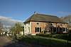 |
Zie ook
| Zie de categorie Gemeentelijke monumenten in Meteren van Wikimedia Commons voor mediabestanden over dit onderwerp. |
Bronnen, noten en/of referenties
|
| Gemeentelijke monumenten in Gelderland | ||
|---|---|---|
|
Aalten · Apeldoorn · Arnhem · Barneveld · Berkelland · Beuningen · Bronckhorst · Brummen · Buren · Culemborg · Doesburg · Doetinchem · Druten · Duiven · Ede · Elburg · Epe · Ermelo · Groesbeek · Harderwijk · Hattem · Heerde · Heumen · Lingewaard · Lochem · Maasdriel · Montferland · Neder-Betuwe · Nijkerk · Nijmegen · Nunspeet · Oldebroek · Oost Gelre · Oude IJsselstreek · Overbetuwe · Putten · Renkum · Rheden · Rozendaal · Scherpenzeel · Tiel · Ubbergen · Voorst · Wageningen · West Betuwe · West Maas en Waal · Westervoort · Wijchen · Winterswijk · Zaltbommel · Zevenaar · Zutphen | ||