Lijst van gemeentelijke monumenten in Made
Deze Lijst van gemeentelijke monumenten in Made geeft een overzicht van de gemeentelijke monumenten in de Noord-Brabantse plaats Made, onderdeel van de gemeente Drimmelen.
| Object | Bouwjaar | Architect | Locatie | Coördinaten | Nr. | Afbeelding |
|---|---|---|---|---|---|---|
| Woonhuis | 1925 | Adelstraat 17 | 51° 40' 40" NB, 4° 47' 44" OL | 1719/177 | Upload foto | |
| Dubbel woonhuis | Adelstraat 34 | 51° 40' 41" NB, 4° 48' 3" OL | 1719/179 | Upload foto | ||
| Dubbel woonhuis | Adelstraat 36 | 51° 40' 42" NB, 4° 48' 4" OL | 1719/179 | Upload foto | ||
| Woonhuis | Zandstraat 3 | 51° 40' 43" NB, 4° 48' 7" OL | 1719/181 | Upload foto | ||
| Boerderij | Boerenhoekstraat 64 | 51° 41' 0" NB, 4° 47' 7" OL | 1719/182 | Upload foto | ||
| Boerderij | Burg. v Campenhoutst48 | 51° 40' 55" NB, 4° 47' 18" OL | 1719/183 | Upload foto | ||
| Boerderij | Dahliastraat 71 | 51° 40' 57" NB, 4° 46' 53" OL | 1719/184 | Upload foto | ||
| Woonhuis | Dreef 11 | 51° 40' 48" NB, 4° 47' 29" OL | 1719/185 | Upload foto | ||
| Winkel,woonhuis | Dreef 19 | 51° 40' 47" NB, 4° 47' 27" OL | 1719/186 | Upload foto | ||
| Woonhuis | Dreef 51 | 51° 40' 47" NB, 4° 47' 18" OL | 1719/187 | Upload foto | ||
| Woonhuis | G. Schalckenstraat 18 | 51° 40' 35" NB, 4° 47' 36" OL | 1719/191 | Upload foto | ||
| Woonhuis | G. Schalckenstraat 20 | 51° 40' 34" NB, 4° 47' 36" OL | 1719/192 | Upload foto | ||
| Langgevelboerderij | 19e-eeuws[1] | G. Schalckenstraat 33 | 51° 40' 32" NB, 4° 47' 38" OL | 1719/194 | Upload foto | |
| School Lage Weide | Julianastraat 1 | 51° 40' 53" NB, 4° 47' 34" OL | 1719/195 | Upload foto | ||
| Boerderij,woonhuis | Kerkdijk 8 | 51° 40' 44" NB, 4° 46' 33" OL | 1719/196 | Upload foto | ||
| Heilig Hartbeeld | 1948 | Henri Jonkers | Kerkstraat | 51° 40' 51" NB, 4° 47' 40" OL | 1719/197 | Upload foto |
| Woonhuis | Kerkstraat 1 | 51° 40' 50" NB, 4° 47' 34" OL | 1719/198 | Upload foto | ||
| Pastorie | Kerkstraat 6 | 51° 40' 50" NB, 4° 47' 37" OL | 1719/199 | Upload foto | ||
| Sint-Bernarduskerk | 1870[2] | J. Verheyen | Kerkstraat 8 | 51° 40' 50" NB, 4° 47' 39" OL | 1719/200 | 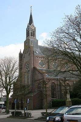 |
| Oude pastorie, tegenwoordig café Het Oud mannenhuis[1] | circa 1840 | Kerkstraat 8a | 51° 40' 50" NB, 4° 47' 39" OL | 1719/201 | Upload foto | |
| Kapel | Kerkstraat 10 | 51° 40' 51" NB, 4° 47' 41" OL | 1719/202 | 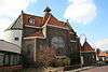 | ||
| Winkel,woonhuis | Kerkstraat 25 | 51° 40' 52" NB, 4° 47' 42" OL | 1719/205 | Upload foto | ||
| Winkel,woonhuis | Kerkstraat27 | 51° 40' 52" NB, 4° 47' 43" OL | 1719/205 | Upload foto | ||
| Bakkerij,woonhuis | Kerkstraat 29 | 51° 40' 52" NB, 4° 47' 43" OL | 1719/206 | Upload foto | ||
| Woonhuis | L. Eykenstraat 76-78 | 51° 40' 53" NB, 4° 47' 48" OL | 1719/209 | Upload foto | ||
| Woonhuis | Marktstraat 6 | 51° 40' 40" NB, 4° 47' 36" OL | 1719/210 | Upload foto | ||
| Winkel,woonhuis | Marktstraat 19 | 51° 40' 42" NB, 4° 47' 34" OL | 1719/211 | Upload foto | ||
| Woonhuis | Marktstraat 24 | 51° 40' 43" NB, 4° 47' 35" OL | 1719/212 | Upload foto | ||
| Winkel,woonhuis | Marktstraat 28 | 51° 40' 44" NB, 4° 47' 35" OL | 1719/213 | Upload foto | ||
| Winkel,woonhuis | Nieuwstraat 39 | 51° 40' 35" NB, 4° 47' 26" OL | 1719/215 | Upload foto | ||
| Woonhuis | Nieuwstraat 90 | 51° 40' 30" NB, 4° 47' 9" OL | 1719/216 | Upload foto | ||
| Woonhuis | Nieuwstraat 98 | 51° 40' 29" NB, 4° 47' 6" OL | 1719/217 | Upload foto | ||
| Woonhuis | Nieuwstraat 102 | 51° 40' 28" NB, 4° 47' 2" OL | 1719/219 | Upload foto | ||
| Langgevelboerderij | Oude Kerkstraat 54 | 51° 40' 37" NB, 4° 46' 38" OL | 1719/220 | Upload foto | ||
| Boerderij | Oude Kerkstraat 82 | 51° 40' 46" NB, 4° 46' 32" OL | 1719/221 | Upload foto | ||
| Voormalige pastorie | Pastoriestraat 1 | 51° 40' 46" NB, 4° 47' 56" OL | 1719/222 | Upload foto | ||
| Woonhuis | Patronaatstraat 5 | 51° 40' 47" NB, 4° 47' 36" OL | 1719/223 | Upload foto | ||
| Woonhuis | Patronaatstraat 6 | 51° 40' 46" NB, 4° 47' 38" OL | 1719/224 | Upload foto | ||
| Woonhuis | Patronaatstraat 8 | 51° 40' 45" NB, 4° 47' 38" OL | 1719/226 | Upload foto | ||
| Woonhuis | Patronaatstraat 11 | 51° 40' 46" NB, 4° 47' 39" OL | 1719/227 | Upload foto | ||
| Dubbel woonhuis | Patronaatstraat 2 | 51° 40' 46" NB, 4° 47' 37" OL | 1719/228 | Upload foto | ||
| Dubbel woonhuis | Patronaatstraat 4 | 51° 40' 46" NB, 4° 47' 37" OL | 1719/228 | Upload foto | ||
| Woonhuis | Plukmadestraat 1 | 51° 40' 55" NB, 4° 47' 49" OL | 1719/230 | Upload foto | ||
| Boerderij | Prinsenpolderstraat 21 | 51° 40' 43" NB, 4° 47' 14" OL | 1719/231 | 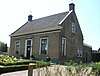 | ||
| Woonhuis | Rozenbloemstraat 23 | 51° 40' 53" NB, 4° 47' 19" OL | 1719/232 | Upload foto | ||
| Woonhuis | Rozenbloemstraat 58 | 51° 41' 1" NB, 4° 47' 32" OL | 1719/233 | Upload foto | ||
| Woonhuis | Stationsstraat 8 | 51° 40' 58" NB, 4° 47' 46" OL | 1719/234 | Upload foto | ||
| Woonhuis | Stationsstraat 17 | 51° 40' 58" NB, 4° 47' 45" OL | 1719/235 | Upload foto | ||
| Woonhuis | Stationsstraat 23 | 51° 40' 59" NB, 4° 47' 45" OL | 1719/236 | Upload foto | ||
| Smederij,woonhuis | Stuivezandsestraat 5 | 51° 40' 22" NB, 4° 46' 36" OL | 1719/238 | Upload foto | ||
| Woning | Voorstraat 13 | 51° 40' 55" NB, 4° 48' 30" OL | 1719/241 | Upload foto | ||
| Lboerderij | Voorstraat 33 | 51° 41' 8" NB, 4° 48' 21" OL | 1719/242 | Upload foto | ||
| Vlaamse schuur | Voorstraat 35 | 51° 41' 13" NB, 4° 48' 18" OL | 1719/243 | Upload foto | ||
| Boerderij | Wilhelminastraat 7 | 51° 40' 54" NB, 4° 47' 44" OL | 1719/244 | Upload foto | ||
| Pastorie | Zuideindsestraat 1 | 51° 40' 27" NB, 4° 47' 1" OL | 1719/246 | Upload foto | ||
| R.K. Blasiuskerk | 1930[3] | J. Oomen | Zuideindsestraat 3 | 51° 40' 26" NB, 4° 46' 60" OL | 1719/247 | 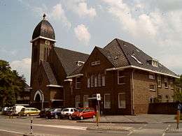 |
| Klooster,school | 1930[4] | B.P.J. Oomen, A.W. Oomen | Zuideindsestraat 5 | 51° 40' 26" NB, 4° 46' 58" OL | 1719/248 | Upload foto |
Zie ook
| Zie de categorie Gemeentelijke monumenten in Made van Wikimedia Commons voor mediabestanden over dit onderwerp. |
Bronnen, noten en/of referenties
|
This article is issued from
Wikipedia.
The text is licensed under Creative
Commons - Attribution - Sharealike.
Additional terms may apply for the media files.