Lijst van gemeentelijke monumenten in Woerden
De gemeente Woerden kent 126 gemeentelijke monumenten, hieronder een overzicht. Zie ook de rijksmonumenten in Woerden.
Harmelen
De plaats Harmelen kent 23 gemeentelijke monumenten:
| Object | Bouwjaar | Architect | Locatie | Coördinaten | Nr. | Afbeelding |
|---|---|---|---|---|---|---|
| Langhuisboerderij Elisabeth Woutrina Hoeve | Breudijk 27 | 52° 6' 6" NB, 4° 57' 28" OL | 0632/WN001 |  | ||
| Langhuisboerderij Johanna Hoeve | Breudijk 29 | 52° 6' 7" NB, 4° 57' 37" OL | 0632/WN002 |  | ||
| Woonhuis/winkel | Dorpsstraat 30 | 52° 5' 30" NB, 4° 57' 50" OL | 0632/WN003 |  | ||
| Woonhuis Huis Landzigt | Dorpsstraat 35 | 52° 5' 27" NB, 4° 57' 58" OL | 0632/WN004 |  | ||
| Woonhuis/winkel | Dorpsstraat 42 | 52° 5' 30" NB, 4° 57' 48" OL | 0632/WN005 |  | ||
| Kerkgebouw en -onderdeel St. Bavokapel (Gazakapel) | Dorpsstraat achter 70 | 0632/WN006 | Upload foto | |||
| Woonhuis/winkel | Dorpsstraat 81 | 52° 5' 29" NB, 4° 57' 48" OL | 0632/WN007 |  | ||
| Woonhuis/horeca Tolhuis | Dorpsstraat 103 | 52° 5' 28" NB, 4° 57' 45" OL | 0632/WN008 |  | ||
| Woonhuis | Dorpsstraat 164 | 52° 5' 26" NB, 4° 57' 26" OL | 0632/WN009 |  | ||
| Woonhuis | Dorpsstraat 166 | 52° 5' 25" NB, 4° 57' 26" OL | 0632/WN010 |  | ||
| Woonhuis | Dorpsstraat 187 | 52° 5' 25" NB, 4° 57' 30" OL | 0632/WN011 | .jpg) | ||
| Langhuisboerderij Baron van Wassenaar Hoeve | Gerverscop 9 | 52° 6' 48" NB, 4° 56' 34" OL | 0632/WN012 |  | ||
| Dwarshuisboerderij | Gerverscop 13-13a | 52° 6' 56" NB, 4° 56' 54" OL | 0632/WN013 |  | ||
| Langhuisboerderij | Gerverscop 27 | 52° 7' 14" NB, 4° 57' 42" OL | 0632/WN014 | Upload foto | ||
| Herenboerderij Eikenstein | Haanwijk 15 | 52° 5' 31" NB, 4° 57' 3" OL | 0632/WN015 | Upload foto | ||
| Langhuisboerderij | Haanwijk 17 | 52° 5' 34" NB, 4° 56' 54" OL | 0632/WN016 | Upload foto | ||
| Woonhuis | Jaagpad 5 en 6 | 52° 5' 26" NB, 4° 57' 42" OL | 0632/WN017 | Upload foto | ||
| Woonhuis | Jaagpad 16 | 52° 5' 24" NB, 4° 57' 17" OL | 0632/WN018 | Upload foto | ||
| Woonhuis Villa Vredehof | Leidsestraatweg 35-37 | 52° 5' 47" NB, 4° 56' 40" OL | 0632/WN019 |  | ||
| Langhuisboerderij | Leidsestraatweg 39 | 52° 5' 49" NB, 4° 56' 37" OL | 0632/WN020 |  | ||
| Langhuisboerderij | Reijerscop 16 | 52° 4' 38" NB, 4° 58' 34" OL | 0632/WN021 | Upload foto | ||
| Langhuisboerderij Landlust | Reijerscop 28 | 52° 4' 42" NB, 4° 57' 40" OL | 0632/WN022 | Upload foto | ||
| Weg- en waterwerken Kwakelbrug | Uitweg ong. | 0632/WN023 |  |
Kamerik
De plaats Kamerik kent 18 gemeentelijke monumenten:
| Object | Bouwjaar | Architect | Locatie | Coördinaten | Nr. | Afbeelding |
|---|---|---|---|---|---|---|
| Dwarshuisboerderij Buitenlust | s-Gravensloot 19 en 20 | 52° 5' 39" NB, 4° 52' 46" OL | 0632/WN024 |  | ||
| Woonhuis (complex) De Hoge Boom | s-Gravensloot 38 en 39 | 52° 5' 38" NB, 4° 52' 49" OL | 0632/WN025 | _De_Hoge_Boom_2013-09-15_16-26-43.jpg) | ||
| Kerkonderdeel/orgel Vermeulenorgel | Hallehuis 4 | 52° 6' 43" NB, 4° 53' 36" OL | 0632/WN026 | Upload foto | ||
| Dwarshuisboerderij | Houtdijk 14 | 52° 6' 24" NB, 4° 55' 60" OL | 0632/WN027 | Upload foto | ||
| Zomerhuis | Houtdijk 15 | 52° 6' 24" NB, 4° 56' 0" OL | 0632/WN028 | Upload foto | ||
| Krukhuisboerderij | Houtdijk 16 | 52° 6' 23" NB, 4° 56' 2" OL | 0632/WN029 | Upload foto | ||
| Dwarshuisboerderij Hofstede de Kruipin | Kruipin, de 1 | 52° 5' 47" NB, 4° 53' 37" OL | 0632/WN030 |  | ||
| Langhuisboerderij Aletta Hoeve | Mijzijde 97 | 52° 7' 8" NB, 4° 53' 37" OL | 0632/WN031 | Upload foto | ||
| Woonhuis | Mijzijde 102 | 52° 7' 16" NB, 4° 53' 37" OL | 0632/WN032 | Upload foto | ||
| Kerkgebouw en -onderdeel R.K. St. Hippolytus kerk | 1914-1915 | Wolter te Riele | Mijzijde 131 en132 | 52° 7' 31" NB, 4° 53' 36" OL | 0632/WN033 |  |
| Langhuisboerderij | Mijzijde 166 en167 | 0632/WN034 | Upload foto | |||
| Schoolgebouw Elim | Talsma, burg. 19 | 52° 6' 41" NB, 4° 53' 41" OL | 0632/WN035 | Upload foto | ||
| Langhuisboerderij De Herfst | Teckop 38 | 52° 8' 10" NB, 4° 55' 50" OL | 0632/WN036 | Upload foto | ||
| Woonhuis Villa Dorothee | Teylingenweg, van 17 | 52° 6' 31" NB, 4° 53' 40" OL | 0632/WN037 | Upload foto | ||
| Woonhuis | Teylingenweg, van 70 -71 | 52° 6' 47" NB, 4° 53' 41" OL | 0632/WN038 | Upload foto | ||
| Langhuisboerderij Vrede Best | Teylingenweg, van 107 | 52° 7' 15" NB, 4° 53' 41" OL | 0632/WN039 | Upload foto | ||
| Langhuisboerderij | Teylingenweg, van 112 | 52° 7' 24" NB, 4° 53' 40" OL | 0632/WN040 |  | ||
| Langhuisboerderij | Teylingenweg, van 156 | 52° 8' 35" NB, 4° 53' 35" OL | 0632/WN041 | Upload foto |
Woerden
De plaats Woerden kent 71 gemeentelijke monumenten:
| Object | Bouwjaar | Architect | Locatie | Coördinaten | Nr. | Afbeelding |
|---|---|---|---|---|---|---|
| Woonhuis | Achterstraat 5 | 52° 5' 15" NB, 4° 53' 7" OL | 0632/WN042 |  | ||
| Fabriekspand | Achterstraat 6 | 52° 5' 15" NB, 4° 53' 7" OL | 0632/WN043 |  | ||
| Schoolgebouw | Achterstraat 7 | 52° 5' 15" NB, 4° 53' 8" OL | 0632/WN044 |  | ||
| Woonhuis | Bakker, Jan de 14a | 52° 5' 15" NB, 4° 53' 7" OL | 0632/WN045 |  | ||
| Langhuisboerderij | Barwoutswaarder 85 | 52° 4' 40" NB, 4° 50' 2" OL | 0632/WN046 | Upload foto | ||
| Funerair erfgoed Familie begraafplaats Groeneveld | 1813 | Brauwstraat, de ong. | 52° 5' 18" NB, 4° 52' 34" OL | 0632/WN047 |  | |
| Langhuisboerderij De Posthoorn | Breeveld 7 | 52° 5' 52" NB, 4° 54' 56" OL | 0632/WN048 |  | ||
| Langhuisboerderij OudRiethove | Breeveld 17 | 52° 6' 16" NB, 4° 55' 59" OL | 0632/WN049 |  | ||
| Langhuisboerderij | Cattenbroekerdijk 18 | 52° 4' 36" NB, 4° 55' 0" OL | 0632/WN050 |  | ||
| Woonhuis (complex) | Costerusstraat 2-14 | 52° 5' 9" NB, 4° 52' 52" OL | 0632/WN051 | _2013-09-25_10-38-34.jpg) | ||
| Terrein Het Exercitieterrein | Exercitieterrein ong. | 52° 5' 13" NB, 4° 53' 19" OL | 0632/WN052 |  | ||
| Woonhuis | s-Gravensloot 101 | 52° 5' 41" NB, 4° 53' 16" OL | 0632/WN053 |  | ||
| Café de Pompier | Groenendaal 17 | 52° 5' 10" NB, 4° 52' 60" OL | 0632/WN054 |  | ||
| "De Smidse" | Havenstraat 12 | 52° 5' 8" NB, 4° 53' 6" OL | 0632/WN055 |  | ||
| Pakhuis | Havenstraat 15 | 52° 5' 9" NB, 4° 53' 6" OL | 0632/WN056 | 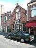 | ||
| Pakhuis | Havenstraat 19 | 52° 5' 9" NB, 4° 53' 6" OL | 0632/WN057 |  | ||
| Kantoor Het Gemeendelandshuis van hetGrootWaterschap van Woerden | Havenstraat 30 | 52° 5' 6" NB, 4° 53' 5" OL | 0632/WN058 |  | ||
| Woonhuis/winkel | Havenstraat 39 | 52° 5' 7" NB, 4° 53' 6" OL | 0632/WN059 |  | ||
| Woonhuis/winkel | Havenstraat 50 | 52° 5' 4" NB, 4° 53' 4" OL | 0632/WN060 |  | ||
| Woonhuis/werkplaats | Havenstraat 53 | 52° 5' 6" NB, 4° 53' 5" OL | 0632/WN061 |  | ||
| Woonhuis | Hendrikkade, Pr. 13 | 52° 5' 1" NB, 4° 53' 6" OL | 0632/WN062 | 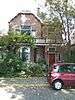 | ||
| Gemaal Gemaal Barwoutswaarder | Hoge Rijndijk nabij 15 | 52° 5' 2" NB, 4° 52' 1" OL | 0632/WN063 |  | ||
| Woonhuis/winkel | Kruisstraat 8 | 52° 5' 11" NB, 4° 53' 7" OL | 0632/WN064 |  | ||
| Opslag | Leidsestraatweg 7a | 52° 5' 16" NB, 4° 52' 46" OL | 0632/WN065 |  | ||
| Pakhuis | Leidsestraatweg 19-21 | 52° 5' 16" NB, 4° 52' 44" OL | 0632/WN066 |  | ||
| Stoomwasserij en directeurswoning Wasserij van Slagmaat | Leidsestraatweg 32, 36 en38 | 52° 5' 17" NB, 4° 52' 43" OL | 0632/WN067 |  | ||
| Woonhuis en pakhuis | Leidsestraatweg 41 a-c | 52° 5' 16" NB, 4° 52' 40" OL | 0632/WN068 |  | ||
| Woonhuis | Leidsestraatweg 70 | 52° 5' 14" NB, 4° 52' 28" OL | 0632/WN069 |  | ||
| Woonhuis | Leidsestraatweg 90 | 52° 5' 11" NB, 4° 52' 19" OL | 0632/WN070 |  | ||
| Pakhuis | Leidsestraatweg 229 | 52° 5' 11" NB, 4° 51' 49" OL | 0632/WN071 |  | ||
| Woonhuis/herenhuis | Leidsestraatweg 237 | 52° 5' 12" NB, 4° 51' 42" OL | 0632/WN072 |  | ||
| Woonhuis | Linschoterweg 5 | 52° 5' 2" NB, 4° 53' 34" OL | 0632/WN073 |  | ||
| Kaasbel | Meulmansweg ong. | 52° 5' 10" NB, 4° 52' 57" OL | 0632/WN074 |  | ||
| Kaaspakhuis | Meulmansweg 4 | 52° 5' 11" NB, 4° 52' 57" OL | 0632/WN075 |  | ||
| Schoolgebouw en woonhuis Minkema | C.J. Kruisweg | Minkemalaan 1 | 52° 5' 4" NB, 4° 53' 46" OL | 0632/WN076 |  | |
| Woonhuis | Nieuwstraat 4 | 52° 5' 16" NB, 4° 53' 3" OL | 0632/WN077 |  | ||
| Woonhuis/herenhuis Welgelegen | Oostdam 1 | 52° 5' 11" NB, 4° 53' 20" OL | 0632/WN078 | 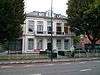 | ||
| Woonhuis | Oostdam 2 | 52° 5' 11" NB, 4° 53' 21" OL | 0632/WN079 |  | ||
| Woonhuis Alpha | Oostdam 3 | 52° 5' 11" NB, 4° 53' 21" OL | 0632/WN080 |  | ||
| Woonhuis | Oostdam 4 | 52° 5' 11" NB, 4° 53' 22" OL | 0632/WN081 | 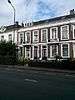 | ||
| Woonhuis | Oostdam 5 | 52° 5' 12" NB, 4° 53' 22" OL | 0632/WN082 |  | ||
| Woonhuis | Oostdam 6 | 52° 5' 12" NB, 4° 53' 23" OL | 0632/WN083 |  | ||
| Woonhuis | Oostdam 7 | 52° 5' 12" NB, 4° 53' 23" OL | 0632/WN084 |  | ||
| Woonhuis | Oostdam 8 | 52° 5' 12" NB, 4° 53' 23" OL | 0632/WN085 |  | ||
| Woonhuis | Oostdam 9 | 52° 5' 12" NB, 4° 53' 23" OL | 0632/WN086 |  | ||
| Woonhuis Omega | Oostdam 10 | 52° 5' 12" NB, 4° 53' 24" OL | 0632/WN087 |  | ||
| Woonhuis (complex) | Oudheusdenstraat, van 4-7 | 52° 5' 10" NB, 4° 52' 51" OL | 0632/WN088 | _2013-09-25_10-37-47.jpg) | ||
| Koetshuis/woning | Rietveld 13 | 52° 5' 15" NB, 4° 51' 27" OL | 0632/WN089 | Upload foto | ||
| Langhuisboerderij | Rietveld 34 | 52° 5' 23" NB, 4° 51' 29" OL | 0632/WN090 | Upload foto | ||
| Dwarshuisboerderij Hoeve t Slootje | Rietveld 54 | 52° 5' 23" NB, 4° 51' 6" OL | 0632/WN091 |  | ||
| Langhuisboerderij Boer met genoegen | 1910 | Rietveld 64 | 52° 5' 15" NB, 4° 50' 43" OL | 0632/WN092 | Upload foto | |
| Woonhuis Rozenbrug en dienstwoning | Rijnkade 1 | 52° 5' 15" NB, 4° 52' 49" OL | 0632/WN093 |  | ||
| Woonhuis | Rijnkade 6 | 52° 5' 15" NB, 4° 52' 47" OL | 0632/WN094 |  | ||
| Woonhuis/magazijn | Rijnstraat 35 | 52° 5' 12" NB, 4° 53' 6" OL | 0632/WN095 |  | ||
| Woonhuis | Rijnstraat 42 | 52° 5' 9" NB, 4° 53' 7" OL | 0632/WN096 |  | ||
| Station Woerden | Stationsweg 1 t/m 3 | 52° 5' 9" NB, 4° 53' 32" OL | 0632/WN097 | _-_Woerden_-_20216277_-_RCE.jpg) | ||
| Woonhuis Kortenoord | Utrechtsestraatweg 1 | 52° 5' 13" NB, 4° 53' 30" OL | 0632/WN098 |  | ||
| Kaaspakhuis | Utrechtsestraatweg 23a | 52° 5' 15" NB, 4° 53' 34" OL | 0632/WN099 |  | ||
| Woonhuis/herenhuis | Utrechtsestraatweg 104 | 52° 5' 37" NB, 4° 54' 9" OL | 0632/WN100 | 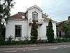 | ||
| Woonhuis/winkel | Voorstraat 1 | 52° 5' 15" NB, 4° 53' 2" OL | 0632/WN101 | 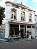 | ||
| Woonhuis/winkel | Voorstraat 14 | 52° 5' 14" NB, 4° 53' 3" OL | 0632/WN102 |  | ||
| Woonhuis/winkel | Voorstraat 26 | 52° 5' 13" NB, 4° 53' 5" OL | 0632/WN103 |  | ||
| Woonhuis/winkel | Voorstraat 34 | 52° 5' 12" NB, 4° 53' 5" OL | 0632/WN104 |  | ||
| Woonhuis/winkel | Voorstraat 36 | 52° 5' 12" NB, 4° 53' 7" OL | 0632/WN105 |  | ||
| Woonhuis/winkel | Voorstraat 44-44a | 52° 5' 11" NB, 4° 53' 8" OL | 0632/WN106 |  | ||
| Funerair erfgoed Israëlitische begraafplaats | Westdampark ong. | 52° 5' 19" NB, 4° 52' 53" OL | 0632/WN107 |  | ||
| Raadhuis | Westdam 3 | 52° 5' 17" NB, 4° 52' 57" OL | 0632/WN108 |  | ||
| Gereformeerde Opstandingskerk en orgel | Wilhelminaweg 8 | 52° 5' 2" NB, 4° 53' 2" OL | 0632/WN109 | 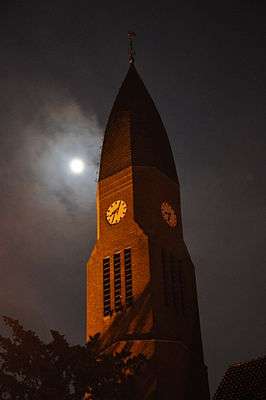 | ||
| Woonhuis/horeca Walzicht | Wilhelminaweg 22 | 52° 5' 4" NB, 4° 53' 8" OL | 0632/WN110 |  | ||
| Militaire werkplaats Wasserij Defensieeiland | Wilhelminaweg 46 | 52° 5' 4" NB, 4° 53' 16" OL | 0632/WN111 |  | ||
| Langhuisboerderij Hoeve Panorama | Zegveldse Uitweg 4-4a | 52° 5' 24" NB, 4° 51' 37" OL | 0632/WN112 |  |
Zegveld
De plaats Zegveld kent 14 gemeentelijke monumenten:
| Object | Bouwjaar | Architect | Locatie | Coördinaten | Nr. | Afbeelding |
|---|---|---|---|---|---|---|
| Langhuisboerderij Vaders wens | Hoofdweg 22-24 | 52° 6' 50" NB, 4° 50' 24" OL | 0632/WN113 | Upload foto | ||
| Terreinbegrenzing Toegangshekwerk | Hoofdweg 59-61 | 52° 6' 42" NB, 4° 50' 29" OL | 0632/WN114 | Upload foto | ||
| Kerkgebouw N.H. kerk | Hoofdweg 72 | 52° 6' 41" NB, 4° 50' 35" OL | 0632/WN115 | Upload foto | ||
| Woonhuis | Hoofdweg 76 | 52° 6' 39" NB, 4° 50' 37" OL | 0632/WN116 | Upload foto | ||
| Langhuisboerderij Kerkzicht | Hoofdweg 79 | 52° 6' 40" NB, 4° 50' 32" OL | 0632/WN117 | Upload foto | ||
| Woonhuis | Hoofdweg 81 | 52° 6' 40" NB, 4° 50' 33" OL | 0632/WN118 | Upload foto | ||
| Woonhuis/horeca De Swaan | Hoofdweg 83 | 52° 6' 40" NB, 4° 50' 33" OL | 0632/WN119 | Upload foto | ||
| Woonhuis/winkel Het Lagerhuis | Hoofdweg 92 | 52° 6' 36" NB, 4° 50' 42" OL | 0632/WN120 | Upload foto | ||
| Schouts- / rechtshuis en schoolgebouw | Hoofdweg 95-97-99 | 52° 6' 39" NB, 4° 50' 34" OL | 0632/WN121 | Upload foto | ||
| Schoolgebouw | Hoofdweg 101 | 52° 6' 31" NB, 4° 50' 46" OL | 0632/WN122 | Upload foto | ||
| Sluis Schutsluis | Hoofdweg nabij 150 | 0632/WN123 | Upload foto | |||
| Kapberg en heeft | Meije, de 310 | 52° 7' 55" NB, 4° 48' 32" OL | 0632/WN124 | Upload foto | ||
| Gemaal Gemaal Zegveld | Nespad 61 | 52° 7' 32" NB, 4° 51' 29" OL | 0632/WN125 |  | ||
| Langhuisboerderij Zwanenbeek | Rondweg 28 | 52° 7' 25" NB, 4° 50' 1" OL | 0632/WN126 | Upload foto |
| Zie de categorie Gemeentelijke monumenten in Woerden van Wikimedia Commons voor mediabestanden over dit onderwerp. |
Bronnen, noten en/of referenties
|
This article is issued from
Wikipedia.
The text is licensed under Creative
Commons - Attribution - Sharealike.
Additional terms may apply for the media files.