Lijst van gemeentelijke monumenten in De Steeg
De plaats De Steeg, onderdeel van de gemeente Rheden, kent 58 gemeentelijke monumenten, hieronder een overzicht:
| Object | Bouwjaar | Architect | Locatie | Coördinaten | Nr. | Afbeelding |
|---|---|---|---|---|---|---|
| Strooien Dorp (deel) | Bentincklaan 04 | 52° 1' 13" NB, 6° 3' 35" OL | 0275/1 |  | ||
| Strooien Dorp (deel) | Bentincklaan 05 | 52° 1' 14" NB, 6° 3' 35" OL | 0275/2 | | ||
| Strooien Dorp (deel) | Bentincklaan 06 | 52° 1' 14" NB, 6° 3' 34" OL | 0275/3 | 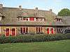 | ||
| Strooien Dorp (deel) | Bentincklaan 07 | 52° 1' 14" NB, 6° 3' 34" OL | 0275/4 | | ||
| Strooien Dorp (deel) | Bentincklaan 08 | 52° 1' 14" NB, 6° 3' 34" OL | 0275/5 |  | ||
| Strooien Dorp (deel) | Bentincklaan 09 | 52° 1' 14" NB, 6° 3' 34" OL | 0275/6 | | ||
| Strooien Dorp (deel) | Bentincklaan 10 | 52° 1' 15" NB, 6° 3' 35" OL | 0275/7 | | ||
| Strooien Dorp (deel) | Bentincklaan 11 | 52° 1' 15" NB, 6° 3' 35" OL | 0275/8 | | ||
| Strooien Dorp (deel), | Bentincklaan 12 | 52° 1' 15" NB, 6° 3' 35" OL | 0275/9 | 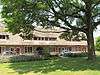 | ||
| Strooien Dorp (deel), | Bentincklaan 13 | 52° 1' 15" NB, 6° 3' 35" OL | 0275/10 | | ||
| Strooien Dorp (deel) | Bentincklaan 14 | 52° 1' 15" NB, 6° 3' 36" OL | 0275/11 | | ||
| Strooien Dorp (deel) | Bentincklaan 15 | 52° 1' 15" NB, 6° 3' 36" OL | 0275/12 | | ||
| Strooien Dorp (deel) | Bentincklaan 16 | 52° 1' 15" NB, 6° 3' 37" OL | 0275/13 | 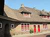 | ||
| Strooien Dorp (deel) | Bentincklaan 17 | 52° 1' 15" NB, 6° 3' 37" OL | 0275/14 | | ||
| Strooien Dorp (deel) | Bentincklaan 18 | 52° 1' 15" NB, 6° 3' 37" OL | 0275/15 | 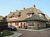 | ||
| Pastorie | Diepesteeg 01 | 52° 1' 11" NB, 6° 3' 41" OL | 0275/17 | 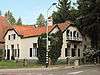 | ||
| Woning aan pand nr 4 | Diepesteeg 02d | 52° 1' 14" NB, 6° 3' 41" OL | 0275/19 | 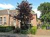 | ||
| Kantoorruimte in bestaand pand 2d | Diepesteeg 02e | 52° 1' 14" NB, 6° 3' 41" OL | 0275/20 | 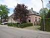 | ||
| Voormalig school met kruisgebouw | Diepesteeg 04 | 52° 1' 15" NB, 6° 3' 40" OL | 0275/21 | 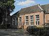 | ||
| Dienstwoning (landarbeiderswoning) | Havikerwaard 48 | 52° 0' 17" NB, 6° 5' 16" OL | 0275/25 | 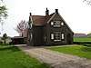 | ||
| Boerderij | Havikerwaard 49 | 52° 0' 23" NB, 6° 5' 21" OL | 0275/26 | 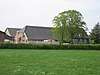 | ||
| Boerderij 'De Pol', thans tweede woning | Havikerwaard 55 | 52° 1' 0" NB, 6° 5' 23" OL | 0275/29 |  | ||
| Woning met bedrijferuimte 'Veluwezoom' | Hoofdstraat 02 | 52° 0' 60" NB, 6° 3' 2" OL | 0275/31 | 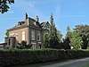 | ||
| TC, voormalig gemeentehuis | Hoofdstraat 04 | 52° 1' 0" NB, 6° 3' 5" OL | 0275/32 | 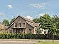 | ||
| Villa "Sonneheerdt" (appartementen) | Hoofdstraat 05 | 52° 1' 0" NB, 6° 3' 6" OL | 0275/33 |  | ||
| Villa Sonneheerdt" (appartementen) | Hoofdstraat 05a | 52° 1' 5" NB, 6° 3' 29" OL | 0275/34 |  | ||
| Villa "Sonneheerdt (appartementen) | Hoofdstraat 05b | 52° 1' 5" NB, 6° 3' 29" OL | 0275/35 |  | ||
| Villa "Sonneheerdt" (appartementen) | Hoofdstraat 05d | 52° 1' 5" NB, 6° 3' 29" OL | 0275/36 |  | ||
| Villa "Sonneheerdt" (appartementen) | Hoofdstraat 05e | 52° 1' 5" NB, 6° 3' 29" OL | 0275/37 |  | ||
| Vm (dienst)woning bij vm. gem.huis, | Hoofdstraat 06 | 52° 1' 1" NB, 6° 3' 7" OL | 0275/38 |  | ||
| Vm gemeentehuis | Hoofdstraat 08 | 52° 1' 1" NB, 6° 3' 9" OL | 0275/39 |  | ||
| "Villa Nova" (pension "lindenhove") | Hoofdstraat 130 | 52° 1' 14" NB, 6° 3' 49" OL | 0275/40 |  | ||
| R.K. Kerk | Hoofdstraat 15 | 52° 1' 11" NB, 6° 3' 39" OL | 0275/42 | 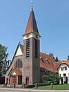 | ||
| Woonhuis "Welgelegen" | Hoofdstraat 23 | 52° 1' 15" NB, 6° 3' 47" OL | 0275/46 | 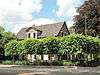 | ||
| Villa "Casa Cara" | Hoofdstraat 29 | 52° 1' 17" NB, 6° 3' 48" OL | 0275/47 | 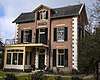 | ||
| Huize 'Rhederpark' | Hoofdstraat 38 | 52° 1' 7" NB, 6° 3' 37" OL | 0275/52 | 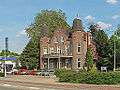 | ||
| Villa "Rhederdal" | Hoofdstraat 48 | 52° 1' 9" NB, 6° 3' 39" OL | 0275/53 | 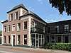 | ||
| Villa "Kastanjeoord" (deel) | Hoofdstraat 58 | 52° 1' 11" NB, 6° 3' 42" OL | 0275/54 |  | ||
| Villa "Kastanjeoord" (deel) | Hoofdstraat 60 | 52° 1' 11" NB, 6° 3' 42" OL | 0275/55 | | ||
| Villa "Kastanjeoord" (deel) | Hoofdstraat 62 | 52° 1' 11" NB, 6° 3' 42" OL | 0275/56 | | ||
| Villa "Kastanjeoord" (deel) | Hoofdstraat 64 | 52° 1' 11" NB, 6° 3' 42" OL | 0275/57 | | ||
| Villa "Kastanjeoord" (deel) | Hoofdstraat 66 | 52° 1' 11" NB, 6° 3' 42" OL | 0275/58 | | ||
| Villa "Kastanjeoord" (deel) | Hoofdstraat 68 | 52° 1' 11" NB, 6° 3' 42" OL | 0275/59 | | ||
| Villa "Kastanjeoord" (deel) | Hoofdstraat 70 | 52° 1' 11" NB, 6° 3' 42" OL | 0275/60 | | ||
| Villa "Kastanjeoord" (deel) | Hoofdstraat 72 | 52° 1' 11" NB, 6° 3' 42" OL | 0275/61 | | ||
| Villa "Kastanjeoord" (deel) | Hoofdstraat 74 | 52° 1' 10" NB, 6° 3' 42" OL | 0275/62 | | ||
| Villa "Kastanjeoord" (deel) | Hoofdstraat 76 | 52° 1' 11" NB, 6° 3' 42" OL | 0275/63 | | ||
| Villa "Kastanjeoord" (deel) | Hoofdstraat 78 | 52° 1' 11" NB, 6° 3' 42" OL | 0275/64 | | ||
| Villa "Kastanjeoord" (deel) | Hoofdstraat 80 | 52° 1' 11" NB, 6° 3' 42" OL | 0275/65 | | ||
| Villa "Avondrood" (deel) | Hoofdstraat 82 | 52° 1' 11" NB, 6° 3' 43" OL | 0275/66 | 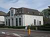 | ||
| Villa "Avondrood" (deel) | Hoofdstraat 84 | 52° 1' 11" NB, 6° 3' 43" OL | 0275/67 |  | ||
| Villa "Avondrood" (deel) | Hoofdstraat 86 | 52° 1' 11" NB, 6° 3' 43" OL | 0275/68 | 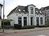 | ||
| Villa "Avondrood" (deel) | Hoofdstraat 88 | 52° 1' 11" NB, 6° 3' 43" OL | 0275/69 | 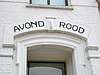 | ||
| Villa "Avondrood" (deel) | Hoofdstraat 90 | 52° 1' 11" NB, 6° 3' 43" OL | 0275/70 | | ||
| Villa "Avondrood" (deel) | Hoofdstraat 92 | 52° 1' 11" NB, 6° 3' 43" OL | 0275/71 | | ||
| Woonhuis bij Middachten | Oversteeg | 52° 1' 3" NB, 6° 3' 53" OL | 0275/75 | Upload foto | ||
| Boerderij "De Hoppenkamp" | Oversteeg 14 | 52° 1' 5" NB, 6° 3' 39" OL | 0275/76 | 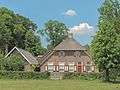 | ||
| Schoolgebouw (voormalig MULO) | Parkweg 04 | 52° 1' 10" NB, 6° 3' 34" OL | 0275/78 | 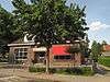 |
Zie ook
| Zie de categorie Gemeentelijke monumenten in De Steeg van Wikimedia Commons voor mediabestanden over dit onderwerp. |
Bronnen, noten en/of referenties
|
This article is issued from
Wikipedia.
The text is licensed under Creative
Commons - Attribution - Sharealike.
Additional terms may apply for the media files.