Havering
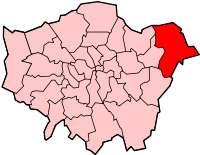
Havering is een borough en een district in de Britse hoofdstad Londen, gelegen in het uiterste oosten van de metropool London. De borough telt 258.000 inwoners. De oppervlakte bedraagt 112 km².
| Borough van Londen | |||
 | |||
| Situering | |||
| Land | Engeland | ||
| County | Outer London | ||
| Regio | London | ||
| Coördinaten | 51°34'53"NB, 0°11'2"OL | ||
| Algemeen | |||
| Oppervlakte | 112,3497[1] km² | ||
| Inwoners (2018[2]) | 257810 (2295 inw./km²) | ||
| ONS-code | E09000016 | ||
| |||
Van de bevolking is 17,7% ouder dan 65 jaar. De werkloosheid bedraagt 2,6% van de beroepsbevolking (cijfers volkstelling 2001).
Wijken in Havering
- Ardleigh Green
- Collier Row
- Cranham
- Elm Park
- Emerson Park
- Gidea Park
- Harold Hill
- Harold Wood
- Hornchurch
- North Ockendon
- Rainham
- Romford
- Upminster
Bronnen, noten en/of referenties
|
This article is issued from
Wikipedia.
The text is licensed under Creative
Commons - Attribution - Sharealike.
Additional terms may apply for the media files.