West End of London
The West End of London (commonly referred to as the West End) is a district of Central London, west of the City of London and north of the River Thames, in which many of the city's major tourist attractions, shops, businesses, government buildings and entertainment venues, including West End theatres, are concentrated.
The term was first used in the early 19th century to describe fashionable areas to the west of Charing Cross.[1] The West End covers parts of the boroughs of Westminster and Camden.[2]
While the City of London is the main business and financial district in London, the West End is the main commercial and entertainment centre of the city. It is the largest central business district in the United Kingdom, comparable to Midtown Manhattan in New York City, Causeway Bay in Hong Kong, Shibuya in Tokyo, or the 8th arrondissement in Paris. It is one of the most expensive locations in the world in which to rent office space.
History
Medieval London comprised two adjacent cities – the City of London in the east, and the City of Westminster in the west.
Over time they came to form the centre of modern London, although each kept its own distinct character and its separate legal identity (for example, the City of London has its own police force and is a distinct county). The City of London became a centre for the banking, financial, legal and professional sectors, while Westminster became associated with the leisure, shopping, commerce, and entertainment sectors, the government, and home to universities and embassies. The modern West End is closely associated with this area of central London.
Lying to the west of the historic Roman and medieval City of London, the West End was long favoured by the rich elite as a place of residence because it was usually upwind of the smoke drifting from the crowded City.[3] It was close to the royal seat of power at the Palace of Westminster (now home to Parliament), and is largely contained within the City of Westminster (one of the 32 London boroughs).
Developed in the 17th, 18th and 19th centuries, it was built as a series of palaces, expensive town houses, fashionable shops and places of entertainment. The areas closest to the City around Holborn, Seven Dials, and Covent Garden contained poorer communities that were cleared and redeveloped in the 19th century.
Boundaries
As the West End is a term used colloquially by Londoners and is not an official geographical or municipal definition, its exact constituent parts are up for debate. Westminster City Council's 2005 report Vision for the West End included the following areas in its definition: Covent Garden, Soho, Chinatown, Leicester Square, the shopping streets of Oxford Street, Regent Street and Bond Street, the area encompassing Trafalgar Square, the Strand and Aldwych, and the district known as Theatreland. The Edgware Road to the north-west and the Victoria Embankment to the south-east were also covered by the document but were treated as "adjacent areas" to the West End.[4]
According to Ed Glinert's West End Chronicles (2006) the districts falling within the West End are Mayfair, Soho, Covent Garden, Fitzrovia and Marylebone.[5] By this definition, the West End borders Temple, Holborn and Bloomsbury to the east, Regent's Park to the north, Paddington, Hyde Park and Knightsbridge to the west, and Victoria and Westminster to the south. Other definitions include Bloomsbury within the West End.[6][7]
One of the local government wards within the City of Westminster is called "West End". This covers a similar area that defined by Glinert: Mayfair, Soho, and parts of Fitzrovia and Marylebone.[8] The population of this ward at the 2011 Census was 10,575.[9]
Activities
Taking a fairly broad definition of the West End, the area contains the main concentrations of most of London's metropolitan activities apart from financial and many types of legal services, which are concentrated primarily in the City of London. There are major concentrations of the following buildings and activities in the West End:
- Art galleries and museums
- Company headquarters outside the financial services sector (although London's many hedge funds are based mainly in the West End)
- Educational institutions
- Embassies
- Government buildings (mainly around Whitehall)
- Hotels
- Institutes, learned societies and think tanks
- Legal institutions
- Media establishments
- Places of entertainment: theatres, cinemas, nightclubs, music venues, bars and restaurants
- Shops
The annual New Year's Day Parade takes place on the streets of the West End.
Notable streets
- Albemarle Street
- Baker Street
- Bond Street
- Carnaby Street
- Charing Cross Road
- Denmark Street
- Gower Street
- Great Marlborough Street
- Great Portland Street
- Harley Street
- Haymarket
- High Holborn
- Kingsway
- Neal Street
- Old Compton Street
- Oxford Street
- Park Lane
- Piccadilly
- Regent Street
- Savile Row
- Shaftesbury Avenue
- Strand
- Tottenham Court Road
- Wardour Street
Notable squares and circuses
The West End is laid out with many notable public squares and circuses.
- Berkeley Square
- Cambridge Circus
- Grosvenor Square
- Hyde Park Corner
- Leicester Square
- Manchester Square
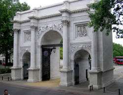
- Marble Arch
- Oxford Circus
- Parliament Square
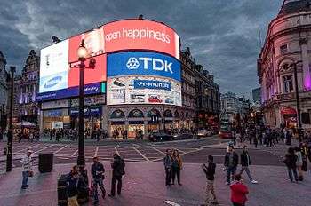
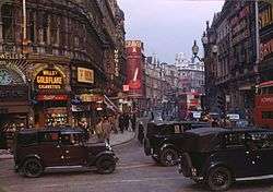
- Piccadilly Circus
- Russell Square
- Soho Square
- St Giles Circus
- Trafalgar Square
Transport
London Underground stations in the West End include:
- Baker Street
- Bond Street
- Charing Cross
- Covent Garden
- Embankment
- Goodge Street
- Great Portland Street
- Green Park
- Holborn
- Hyde Park Corner
- Leicester Square
- Marble Arch
- Oxford Circus
- Piccadilly Circus
- Regent's Park
- Russell Square
- Tottenham Court Road
- Warren Street
References
- Mills, A., Oxford Dictionary of London Place Names, (2001)
- Greater London Authority, The London Plan: The Sub Regions Archived 4 June 2011 at the Wayback Machine
- Robert O. Bucholz and Joseph P. Ward: London: A Social and Cultural History, 1550–1750. Cambridge: Cambridge University Press 2012, p. 333
- Vision for the West End (PDF), Westminster City Council, October 2005, retrieved 14 December 2016
- E. Gilnert, West End Chronicles (Penguin, 2006)
- Atkins, Peter J. "How the West End was won: the struggle to remove street barriers in Victorian London." Journal of Historical Geography 19.3 (1993): 265.
- How the West End was won: the struggle to remove street barriers in Victorian London. Atkins, P J. Journal of Historical Geography; London Vol. 19, Iss. 3, (Jul 1, 1993): 265.
- Westminster City Council ward boundary information
- "City of Westminstee ward population 2011". Neighbourhood Statistics. Office for National Statistics. Retrieved 15 October 2016.
| Wikimedia Commons has media related to West End of London. |