Southwark
Southwark (/ˈsʌðək/ SUDH-ək)[1] is a district of Central London situated in the northwestern portion of the London Borough of Southwark. Centred 1 1⁄2 miles (2.4 km) east of Charing Cross, it fronts the River Thames and the City of London to the north. It was at the lowest bridging point of the Thames in Roman Britain, providing a crossing from Londinium, and for centuries had the only Thames bridge in the area, until a bridge was built upstream more than 10 miles (16 km) to the west.[n 1] It was a 1295-enfranchised (nationally represented) borough in the county of Surrey, apparently created a burh in 886, containing various parishes by the high medieval period, lightly succumbing to City attempts to constrain its free trade and entertainment. Its entertainment district, in its heyday at the time of Shakespare's Globe Theatre (which stood 1599–1642) has revived in the form of the Southbank which overspills imperceptibly into the ancient boundaries of Lambeth and commences at the post-1997 reinvention of the original theatre, Shakespeare's Globe, incorporating other smaller theatre spaces, an exhibition about Shakespeare's life and work and which neighbours Vinopolis and the London Dungeon.
Southwark
| |
|---|---|
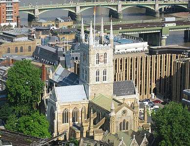 Southwark Cathedral | |
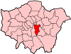
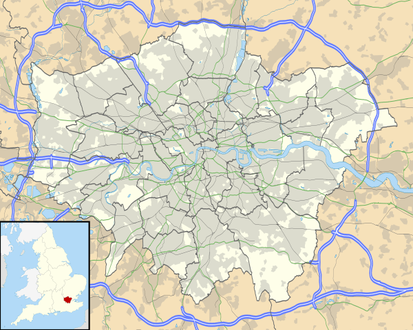 Southwark Location within Greater London | |
| OS grid reference | TQ325795 |
| • Charing Cross | 1.5 mi (2.4 km) W |
| London borough |
|
| Ceremonial county | Greater London |
| Region | |
| Country | England |
| Sovereign state | United Kingdom |
| Post town | LONDON |
| Postcode district | SE1 |
| Dialling code | 020 |
| Police | Metropolitan |
| Fire | London |
| Ambulance | London |
| UK Parliament |
|
| London Assembly |
|
After the 18th-century decline of Southwark's small wharves, the borough rapidly grew in population and saw the growth of great docks, printing/paper, railways, goods yards, small artisan and other often low-wage industries and Southwark was among many such inner districts to see slum clearance and replacement largely with social housing during the late 19th and early 20th centuries. It is now at an advanced stage of regeneration and has the City Hall offices of the Greater London Authority. At its heart is the area known as Borough, which has an eclectic covered and semi-covered market and numerous food and drink venues as well as the skyscraper The Shard. Another landmark is Southwark Cathedral, a priory then parish church, created a cathedral in 1905, noted for its Merbecke Choir.
The area has three main tube stations: Borough, Southwark nearby and one close to the river which is combined with a major railway station above, London Bridge.
History
Toponymy
The name Suthriganaweorc[2] or Suthringa geweorche[3] is recorded for the area in the 10th-century Anglo-Saxon document known as the Burghal Hidage[3] and means "fort of the men of Surrey"[2] or "the defensive work of the men of Surrey".[3] Southwark is recorded in the 1086 Domesday Book as Sudweca. The name means "southern defensive work" and is formed from the Old English sūþ (south) and weorc (work). The southern location is in reference to the City of London to the north, Southwark being at the southern end of London Bridge. In Old English, Surrey means “southern district (or the men of the southern district)”,[4] so the change from “southern district work” to the latter “southern work” may be an evolution based on the elision of the single syllable ge element, meaning district.
Until 1889, the county of Surrey included the present-day London Borough of Southwark, yet the name has been used for various areas of civil administration, including the ancient Borough of Southwark, the Metropolitan Borough of Southwark and the current London Borough of Southwark. The ancient borough of Southwark was also known simply as The Borough—or Borough—and this name, in distinction from 'The City', has persisted as an alternative name for the area. The medieval heart of Southwark was simultaneously referred to as the ward of Bridge Without when administered by the City (from 1550 to 1900) and as an aldermanry until 1978.[2]
Early history
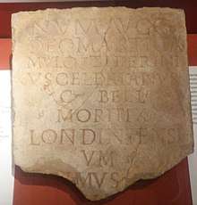
Southwark is sited on a once slightly marshy area south of the River Thames. Recent excavation has revealed prehistoric activity including evidence of early ploughing, burial mounds and ritual activity. Much of the district was, in pre-Roman years, a series of tidal islands in the Thames, formalised into ditches such as the so-called River Neckinger. This formed the best place to bridge the Thames and the area became an important part of Londinium, owing its importance to its position as the endpoint of the Roman London Bridge. Two Roman roads, Stane Street and Watling Street, met at Southwark in what is now Borough High Street. Archaeological work at Tabard Street in 2004 discovered a plaque with the earliest reference to 'Londoners' from the Roman period on it. Londinium was abandoned at the end of the Roman occupation in the early 5th century and both the city and its bridge collapsed in decay. Archaeologically, evidence of settlement is underlain by a largely featureless soil called the Dark Earth which probably (although this is contested) represents an urban area abandoned.
Southwark appears to recover only during the time of King Alfred and his successors. Sometime about 886, the burh of Southwark was created and the Roman city area reoccupied. It was probably fortified to defend the bridge and hence the reemerging City of London to the north. This defensive role is highlighted by the use of the bridge in 1016 as a defence against King Sweyn and his son King Cnut by Ethelred the Unready and again, in 1066, against Duke William the Conqueror. He failed to force the bridge during the Norman conquest of England, but Southwark was devastated.
Southwark appears in the Domesday Book of 1086 within the hundred of Brixton as held by several Surrey manors.[5] Its assets were: Bishop Odo of Bayeux held the monastery[5] (the site of modern Southwark Cathedral) and the tideway, which still exists as St Mary Overie dock; the King owned the church (probably St Olave's) and its tidal stream (St Olave's Dock); the dues of the waterway or mooring place were shared between King William I and Earl Godwin; the King also had the toll of the strand; and 'men of Southwark' had the right to 'a haw and its toll'. Southwark's value to the King was £16.[5] Much of Southwark was originally owned by the church – the greatest reminder of monastic London is Southwark Cathedral, originally the priory of St Mary Overie.
During the early Middle Ages, Southwark developed and was one of the four Surrey towns which returned Members of Parliament for the first commons assembly in 1295. An important market occupied the High Street from some time in the 13th century, which was controlled by the City's officers—it was later removed in order to improve traffic to the Bridge, under a separate Trust by Act of Parliament of 1756 as the Borough Market on the present site. The area was renowned for its inns, especially The Tabard, from which Geoffrey Chaucer's pilgrims set off on their journey in The Canterbury Tales.
Just west of the Bridge was the Liberty of the Clink manor, which was never controlled by the City, but was held under the Bishopric of Winchester's nominal authority. This area therefore became the entertainment district for London, with attractions such as bull and bear-baiting. It also hosted a concentration of brothels.[6] In 1587, Southwark's first playhouse theatre, The Rose, opened. The Rose was set up by Philip Henslowe, and soon became a popular place of entertainment for all classes of Londoners. Both Christopher Marlowe and William Shakespeare, two of the finest writers of the Elizabethan age, worked at the Rose.
In 1599 the Globe Theatre, in which Shakespeare was a shareholder, was erected on the Bankside in the Liberty of the Clink. It burned down in 1613, and was rebuilt in 1614, only to be closed by the Puritans in 1642 and subsequently pulled down not long thereafter. A modern replica called Shakespeare's Globe, has been built near the original site. The impresario in the later Elizabethan period for these entertainments was Shakespeare's colleague Edward Alleyn, who left many local charitable endowments, most notably Dulwich College.
On 26 May 1676, ten years after the Great Fire of London, a great fire broke out, which continued for 17 hours before houses were blown up to create fire breaks. King Charles II and his brother, James, Duke of York, oversaw the effort.
There was also a famous fair in Southwark which took place near the Church of St George the Martyr. William Hogarth depicted this fair in his engraving of Southwark Fair (1733).
Southwark was also the location of several prisons, including those of the Crown or Prerogative Courts, the Marshalsea and King's Bench prisons, those of the local manors' courts, e.g., Borough Compter, The Clink and the Surrey county gaol originally housed at the White Lion Inn (also informally called the Borough Gaol) and eventually at Horsemonger Lane Gaol.
One other local family is of note, the Harvards. John Harvard went to the local parish free school of St Saviour's and on to Cambridge University. He migrated to the Massachusetts Colony and left his library and the residue of his will to the new college there, named after him as its first benefactor. Harvard University maintains a link, having paid for a memorial chapel within Southwark Cathedral (his family's parish church), and where its UK-based alumni hold services. John Harvard's mother's house is in Stratford-upon-Avon.
Urbanisation
In 1836 the first railway in the London area was created, the London and Greenwich Railway, originally terminating at Spa Road and later extended west to London Bridge.
In 1861, another great fire in Southwark destroyed a large number of buildings between Tooley Street and the Thames, including those around Hays Wharf (later replaced by Hays Galleria) and blocks to the west almost as far as St Olave's Church.
The first deep-level underground tube line in London was the City and South London Railway, now the Bank branch of the Northern line, opened in 1890, running from King William Street south through Borough to Stockwell. Southwark, since 1999, is also now served by Southwark, Bermondsey and London Bridge stations on the Jubilee line.
Local governance
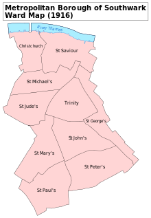
The ancient borough of Southwark initially consisted of the Surrey parishes of St George the Martyr, St Olave, St Margaret and St Mary.[7] St Margaret and St Mary were abolished in 1541 and their former area combined to create Southwark St Saviour. Around 1555 Southwark St Thomas was split off from St Olave, and in 1733 Southwark St John Horsleydown was also split off.[7]
In 1855 the parishes came into the area of responsibility of the Metropolitan Board of Works. The St George the Martyr parish was large enough to be governed by an administrative vestry. St John Horsleydown, St Olave and St Thomas were grouped to form the St Olave District. St Saviour was combined with Southwark Christchurch (the former liberty of Paris Garden) to form the St Saviour's District. In 1889 the area became part of the County of London.[7] St Olave and St Thomas were combined as a single parish in 1896.
The local government arrangements were reorganised in 1900 with a Metropolitan Borough of Southwark created comprising the parishes of Southwark Christchurch, Southwark St Saviours, Southwark St George the Martyr and Newington. The eastern parishes that had formed the St Olave District instead became part of the Metropolitan Borough of Bermondsey. In 1965 the two boroughs were combined with the Metropolitan Borough of Camberwell to form the current London Borough of Southwark.[7]
Relationship with the City of London
Southwark was outside of the control of the City of London and was a haven for criminals and free traders, who would sell goods and conduct trades outside the regulation of the City's Livery Companies. In 1327 the City obtained control from King Edward III of the manor next to the south side of London Bridge known as the Town of Southwark (called latterly the Guildable Manor—i.e., the place of taxes and tolls). The Livery Companies also ensured that they had jurisdiction over the area.
From the Norman period manorial organisation obtained through major lay and ecclesiastic magnates. Southwark still has vestiges of this because of the connection with the City of London. In 1327 the City acquired from Edward III the original vill of Southwark and this was also described as "the borough". In 1536 Henry VIII acquired the Bermondsey Priory properties and in 1538 that of the Archbishop. In 1550 these were sold to the City.
After many decades of petitioning, in 1550 Southwark was incorporated into the City of London as the ward of Bridge Without. However, the Alderman was appointed by the Court of Aldermen and no Common Councilmen were ever elected. This ward was constituted of the original Guildable Manor and the properties previously held by the church, under a charter of Edward VI, latterly called the King's Manor or Great Liberty. These manors are still constituted by the City under a Bailiff and Steward with their Courts Leet and View of Frankpledge Juries and Officers which still meet—their annual assembly being held in November under the present High Steward (the Recorder of London). The Ward and Aldermanry were effectively abolished in 1978, by merging it with the Ward of Bridge Within. These manorial courts were preserved under the Administration of Justice Act 1977. Therefore, between 1750 and 1978 Southwark had two persons (the Alderman and the Recorder) who were members of the City's Court of Aldermen and Common Council who were elected neither by the City freemen or by the Southwark electorate but appointed by the Court of Aldermen.
Governance
The Borough and Bankside Community Council corresponds to the Southwark electoral wards of Cathedrals and Chaucer.[8] They are part of the Bermondsey and Old Southwark Parliament constituency whose Member of Parliament is Neil Coyle. It is within the Lambeth and Southwark London Assembly constituency. Southwark is the location of City Hall, the administrative headquarters of the Greater London Authority and the meeting place of the London Assembly and Mayor of London. Since 2009, Southwark London Borough Council has its main offices at 160 Tooley Street, having moved administrative staff from the town hall in Camberwell. There are five business improvement districts (BIDs) in Southwark; Better Bankside, The Blue Bermondsey, South Bank BID, Team London Bridge, and We Are Waterloo.
Geography
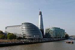
In common with much of the south bank of the Thames, the Borough has seen extensive regeneration in the last decade. Declining wharfage trade, light industry and factories have given way to residential development, shops, restaurants, galleries, bars and most notably major office developments housing international headquarters of accountancy, legal and other professional services consultancies, most notably along London Bridge City and More London between Tooley Street and the riverside. The area is in easy walking distance of the City and the West End. As such it has become a major business centre with many national and international corporations, professional practices and publishers locating to the area. London's tallest skyscraper, the Shard, is next to London Bridge Station.
To the north is the River Thames, London Bridge station and Southwark Cathedral. Borough Market is a well-developed visitor attraction and has grown in size. The adjacent units have been converted and form a gastronomic focus for London. Borough High Street runs roughly north to south from London Bridge towards Elephant and Castle. The Borough runs further to the south than realised; both St George's Cathedral and the Imperial War Museum are within the ancient boundaries, which border nearby Lambeth.
The Borough is generally an area of mixed development, with council estates, major office developments, social housing and high value residential gated communities side by side with each other.
See also
- Southwark, Philadelphia
Notes and references
- References
- "Southwark". The Columbia Lippincott Gazetteer of the World. New York, NY: Columbia University Press. 1952.
- Mills, D. (2000). Oxford Dictionary of London Place Names. Oxford University Press.
- Johnson, David J. (1969). Southwark and the City. Oxford University Press. p. 7. ISBN 978-0-19-711630-2.
- Concise Oxford Dictionary of Place Names, Eilert Erkwall, 4th edition
- Open Domesday Online: Southwark, accessed July 2018.
- Coke, Sir Edward (1644). Institutes of the Laws of England. Third Part. p. 205.
- Youngs, Frederic (1979). Guide to the Local Administrative Units of England. I: Southern England. London: Royal Historical Society. ISBN 0-901050-67-9.
- "Where's your community council". Southwark London Borough Council. Archived from the original on 4 March 2012. Retrieved 4 September 2010.
- Notes
- Namely Kingston Bridge, London from at least 1190s until the building of closer bridges since, starting with Putney Bridge in 1729.
Further reading
- John, Timbs (1867). "Southwark". Curiosities of London (2nd ed.). London: J.C. Hotten. OCLC 12878129.
- Findlay Muirhead, ed. (1922). "Southwark". London and its Environs (2nd ed.). London: Macmillan & Co. OCLC 365061.
External links
- Southwark at Curlie
- Digital Public Library of America. Works related to Southwark, various dates
London Borough of Southwark | ||
|---|---|---|
| Districts |
|  |
| Attractions |
| |
| Markets |
| |
| Bridges and tunnels |
| |
| Parks and open spaces |
| |
| Constituencies |
| |
| Tube and rail stations |
| |
| Other topics |
| |
| ||