Soufrière Hills
The Soufrière Hills are an active, complex stratovolcano with many lava domes forming its summit on the Caribbean island of Montserrat. Many volcanoes in the Caribbean are named Soufrière (French: "sulfur outlet"). These include La Soufrière or Soufrière Saint Vincent on the island of Saint Vincent, and La Grande Soufrière on Guadeloupe. After a long period of dormancy, the Soufrière Hills volcano became active in 1995 and has continued to erupt ever since. Its eruptions have rendered more than half of Montserrat uninhabitable, destroying the capital city, Plymouth, and causing widespread evacuations: about two thirds of the population have left the island.[3]
| Soufrière Hills | |
|---|---|
 Soufrière Hills (before July 2007) | |
| Highest point | |
| Elevation | 1,050 m (3,440 ft) [1] |
| Prominence | 1,050 m (3,440 ft) [1] |
| Coordinates | 16°43′N 62°11′W |
| Geography | |
 Soufrière Hills | |
| Country | |
| Geology | |
| Mountain type | Stratovolcano |
| Volcanic arc/belt | Lesser Antilles Volcanic Arc |
| Last eruption | 2013[2] |

It is andesitic in nature, and the current pattern of activity includes periods of lava dome growth, punctuated by brief episodes of dome collapse which result in pyroclastic flows, ash venting, and explosive eruption. The volcano is monitored by the Montserrat Volcano Observatory. Volcanic gas emissions from this volcano are measured by a Multi-Component Gas Analyzer System, which detects pre-eruptive degassing of rising magmas, improving prediction of volcanic activity.[4]
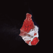
The Centre Hills in the central part of the island and the Silver Hills in the north are older volcanic massifs related to the subduction zone.[5]
Early history
1995–1999 eruption
Seismic activity had occurred in 1897–1898, 1933–1937, and again in 1966–1967, but the eruption that began on 18 July 1995 was the first since the turn of the 20th century in Montserrat.[7] When pyroclastic flows and mudflows began occurring regularly, the capital, Plymouth, was evacuated, and a few weeks later a pyroclastic flow covered the city in several metres of debris.
The first phreatic explosion in this new period of activity occurred on 21 August 1995, and such activity lasted for 18 weeks until it caused an andesitic lava dome formation. This was initially confined by a sector-collapse scar. This period lasted for another 60 weeks, after which there were major dome collapses and two periods of explosive volcanic eruptions and fountain-collapse pyroclastic flows.[8] The explosion blanketed Plymouth, 6 kilometres (3.7 mi) away, in a thick layer of ash and darkened the sky almost completely.
Earthquakes continued to occur in three epicenter zones: beneath the Soufrière Hills volcano, in the ridge running to the north-east, and beneath St George's Hill, about 5 kilometres (3.1 mi) to the north-west.[9] A large eruption on 25 June 1997 resulted in the deaths of nineteen people. The island's airport was directly in the path of the main pyroclastic flow and was completely destroyed.[10] Montserrat's tourist industry also crashed, although it began to recover within fifteen years.[11]
The governments of the United Kingdom and Montserrat led the aid effort, including a £41 million package provided to the Montserrat population; however, riots followed as the people protested that the British Government was not doing enough to aid relief.[12] The riots followed a £10 million aid offer by International Development Secretary Clare Short, prompting the resignation of Bertrand Osborne, then Chief Minister of Montserrat, after allegations of being too pro-British and not demanding a better offer.[13]
The British destroyer HMS Liverpool took a large role in evacuating Montserrat's population to other islands; this included Antigua and Barbuda, who warned they would not be able to cope with many more refugees.[13] About 7,000 people, or two-thirds of the population, left Montserrat; 4,000 went to the United Kingdom.[14]
Destroyed settlements
The following is a list of Montserrat settlements destroyed by the eruption of the Soufrière Hills volcano:
- Bethel
- Bramble
- Dyers
- Fairfield
- Farm
- Farrell's
- Farrell's Yard
- Galway's Estate
- Harris
- Hermitage
- Long Ground
- Morris's
- Plymouth – the capital of Montserrat, initially evacuated in August 1995; abandoned and destroyed in 1997
- Saint Patrick's
- Robuscus Mt
- Soufrière
- Streatham
In addition, the W. H. Bramble Airport was destroyed.
Abandoned settlements
The following is a list of Montserrat settlements abandoned after the eruption of the Soufrière Hills volcano. Most of these settlements were badly affected or inundated by pyroclastic flows between June and December 1997.
Evacuated
- Plymouth, Montserrat
- Amersham
- Cork Hill
- Gages
- Lee's
- Molyneux
- North Olveston (since re-settled)
- Old Towne (since re-settled)
- Saint George's Hill
- Salem (since re-settled)
- Weekes
- Woodlands (since re-settled)
Activity since 1999
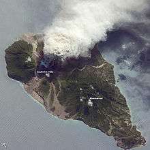
On 24 December 2006, streaks of red from the pyroclastic flows became visible. On 8 January 2007, an evacuation order was issued for areas in the Lower Belham Valley, affecting an additional 100 people.
At 11:27 pm local time on Monday 28 July 2008, an eruption began without any precursory activity. Pyroclastic flow lobes reached Plymouth. These involved juvenile material originating in the collapse of the eruption column. Further, a small part of the eastern side of the lava dome collapsed, generating a pyroclastic flow in Tar River Valley. Several large explosions were registered, with the largest at approximately 11:38 pm. The height of the ash column was estimated at 12,000 m (40,000 ft) above sea level.
The volcano has become one of the most closely monitored volcanoes in the world since its eruption began, with the Montserrat Volcano Observatory taking detailed measurements and reporting on its activity to the government and population of Montserrat. The observatory is operated by the British Geological Survey under contract to the government of Montserrat.
The 9 October 2008 issue of the journal Science suggests that two interconnected magma chambers lie beneath the surface of the volcano on Montserrat – one six kilometres below the surface and the other at 12 kilometres below the surface. They also show a link between surface behaviour and the size of the deeper magma chamber.[15][16]
On 5 February 2010, a vulcanian explosion simultaneously propelled pyroclastic flows down several sides of the mountain, and on 11 February 2010, a partial collapse of the lava dome sent large ash clouds over sections of several nearby islands including Guadeloupe and Antigua. Inhabited areas of Montserrat itself received very little ash accumulation through either event.[17]
Gallery
 Ash plume from Soufrière Hills, 10 March 2004
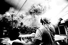 22 September 1997 10:46 a.m. eruption
.jpg) The volcano in 2011
The volcano in 2011.jpg) Debris in Belham River Valley in 2011
Debris in Belham River Valley in 2011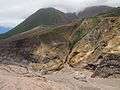 A close up of the volcano in 2012
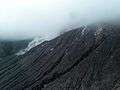 Close up of the volcano in 2012
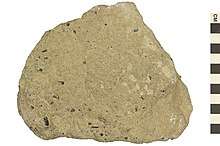
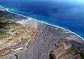 Pyroclastic flow deposits in 2012
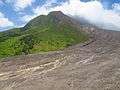 The side of the volcano in 2012, showing the path taken by pyroclastic flows
See also
- List of volcanoes in Montserrat
- List of Seconds From Disaster episodes
References
- Height before the 1995 eruption was 915 m. The eruptions since 1995 have formed a lava dome that has increased the height to 1050 m (2015 estimate): see The CIA World Factbook on Montserrat.
- "Soufrière Hills". Global Volcanism Program. Smithsonian Institution. Retrieved 15 February 2016.
- http://webra.cas.sc.edu/hvri/feature/jun2014_dom.aspx The 1997 Soufriere Hills Eruption
- Christopher, Thomas; Edmonds, Marie; Humphreys, Madeleine C. S.; Herd, Richard A. (2010). "Volcanic gas emissions from Soufrière Hills Volcano, Monserrat 1995-2009, with implications for mafic magma supply and degassing, Geophysical Research Letters, Vol. 37" (PDF). Geophysical Research Letters. 37 (19): n/a. doi:10.1029/2009GL041325.
- "Volcanic History of Montserrat". Montserrat Volcano Observatory. 10 July 2009. Archived from the original on 11 February 2011. Retrieved 17 December 2010.
- "Global Volcanism Program: Eruptive history".
- "Soufrière Hills". Global Volcanism Program. Smithsonian Institution.
- B. Peter Kokelaar (2002). The eruption of Soufrière Hills volcano, Montserrat, from 1995 to 1999. p. 1. ISBN 978-1-86239-098-0.
- Vi︠a︡cheslav Moiseevich Zobin (2003). "Soufrière Hills volcano, Monserrat (6.2.3.)". Introduction to volcanic seismology. 6. pp. 104–7. ISBN 978-0-444-51340-3.
- "BBC country profile: Montserrat". BBC News. 22 September 2009. Retrieved 8 March 2008.
- "Montserrat tourism arrivals up 22 percent in first seven months of 2010 | Caribbean news, Entertainment, Fashion, Politics, Business, Sports…". www.thewestindiannews.com. Retrieved 18 May 2015.
- "UK citizenship for island outposts". The Guardian. London. 18 March 1999. Retrieved 23 May 2010.
- "Montserrat Chief Minister Resigns As People Reject Aid Offer". Politics '97. BBC. Retrieved November 1, 2010.
- "Montserrat evacuation remembered". BBC. 12 September 2005. Retrieved 19 November 2010.
- Elsworth, D; Mattioli, G; Taron, J; Voight, B; Herd, R (October 2008). "Implications of Magma Transfer Between Multiple Reservoirs on Eruption Cycling". Science. 322 (5899): 246–248. Bibcode:2008Sci...322..246E. doi:10.1126/science.1161297. PMID 18845752. Retrieved 2008-10-09.
- "Multiple Magma Reservoirs Affect Volcanic Eruption Cycles", Newswise, 6 October 2008. Retrieved 9 October 2008.
- "Montserrat Volcano Observatory". Montserratvolcanoobservatory.info. Retrieved 27 June 2014.
External links
| Wikimedia Commons has media related to Soufrière Hills. |
- Satellite imagery of 11 February 2010 eruption
- Montserrat Volcano Observatory (MVO) - Current monitoring of the Soufrière Hills Volcano in Montserrat.
- USGS Info on Soufrière Hills Volcano
- 2009 activity at Soufrière Hills Volcano, from NASA Earth Observatory
- Photos taken from a passenger jet of an eruption
- Smithsonian Institution's Global Volcanism Program: Soufrière Hills
| Authority control |
|---|