River Mersey
The River Mersey (/ˈmɜːrzi/) is a river in the North West of England. Its name is derived from the Anglo-Saxon language and translates as "boundary river". The river may have been the border between the ancient kingdoms of Mercia and Northumbria[2] and for centuries it formed part of the boundary between the historic counties of Lancashire and Cheshire.[3]
| River Mersey | |
|---|---|
 The River Mersey at Liverpool, looking towards the Royal Liver Building | |
 | |
| Location | |
| Country | England |
| Counties | Greater Manchester, Cheshire, Merseyside |
| Cities | Liverpool, Manchester |
| Physical characteristics | |
| Source | (source of the River Tame) |
| ⁃ location | west of Buckstones Moss, West Yorkshire |
| ⁃ coordinates | 53.6187°N 2.0035°W |
| ⁃ elevation | 1,552 ft (473 m) |
| 2nd source | (confluence of Tame and Goyt) |
| ⁃ location | Stockport, Greater Manchester |
| ⁃ coordinates | 53.4143°N 2.1565°W |
| ⁃ elevation | 130 ft (40 m) |
| Mouth | |
⁃ location | Liverpool Bay |
| Length | 70 mi (112 km) |
| Basin size | 1,810 sq mi (4,680 km2) |
| Basin features | |
| Designation | |
| Official name | Mersey Estuary |
| Designated | 20 December 1995 |
| Reference no. | 785[1] |
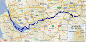
The start of the Mersey is at the confluence of the River Tame and River Goyt in Stockport. It flows westwards through the suburban areas of south Manchester, then into the Manchester Ship Canal at Irlam, becoming a part of the canal and maintaining the canal's water levels. After 4 miles (6.4 km) the river exits the canal, flowing towards Warrington where the river widens. It then narrows as it passes between the towns of Runcorn and Widnes. From Runcorn the river widens into a large estuary, which is 3 miles (4.8 km) across at its widest point near Ellesmere Port. The course of the river then turns north as the estuary narrows between Liverpool and Birkenhead on the Wirral Peninsula to the west, and empties into Liverpool Bay. In total the river flows 70.33 miles (113 km).
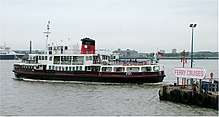
A railway tunnel between Birkenhead and Liverpool as part of the Mersey Railway opened in 1886. Two road tunnels pass under the estuary from Liverpool: the Queensway Tunnel opened in 1934 connecting the city to Birkenhead, and the Kingsway Tunnel, opened in 1971, to Wallasey. A road bridge, completed in 1961 and later named the Silver Jubilee Bridge, crosses between Runcorn and Widnes, adjacent to the Runcorn Railway Bridge which opened in 1868. A second road bridge, the Mersey Gateway, opened in October 2017, carrying a six-lane road connecting Runcorn's Central Expressway with Speke Road and Queensway in Widnes.[4] The Mersey Ferry operates between Pier Head in Liverpool and Woodside in Birkenhead and Seacombe, and has become a tourist attraction offering cruises that provide an overview of the river and surrounding areas.
Water quality in the Mersey was severely affected by industrialisation, and in 1985, the Mersey Basin Campaign was established to improve water quality and encourage waterside regeneration. In 2009 it was announced that the river is "cleaner than at any time since the industrial revolution" and is "now considered one of the cleanest in the UK". The Mersey Valley Countryside Warden Service manages local nature reserves such as Chorlton Ees and Sale Water Park. The river gave its name to Merseybeat, developed by bands from Liverpool, notably the Beatles. In 1965 it was the subject of the top-ten hit single "Ferry Cross the Mersey" by Gerry and the Pacemakers.
Etymology
Its name is derived from the Anglo-Saxon mǣres, 'of a boundary' and ēa, 'a river'.[3] The Mersey was possibly the 'border river' between Mercia and Northumbria.[2] Its Welsh name is Afon Merswy, and it has been given the alternative etymology of Celtic môr-afon meaning "sea river".
Course
The Mersey is formed from three tributaries: the River Etherow, the River Goyt and the River Tame. The modern accepted start of the Mersey is at the confluence of the Tame and Goyt, in central Stockport, Greater Manchester. However, older definitions, and many older maps, place its start a few miles up the Goyt at Compstall; for example the 1911 Encyclopædia Britannica states "It is formed by the junction of the Goyt and the Etherow a short distance below Marple in Cheshire on the first-named stream." The 1784 John Stockdale map shows the River Mersey extending to Mottram, and forming the boundary between Cheshire and Derbyshire.[5] In the west of Stockport it flows at the base of a cliff below the road called Brinksway before reaching flat country.
Stockport to Warrington
From Central Stockport the river flows through or past Heaton Mersey, Didsbury, Northenden, Chorlton-cum-Hardy, Stretford, Sale, Ashton on Mersey, Urmston and Flixton, then at Irlam flows into the Manchester Ship Canal, which is the canalised section of the River Irwell at this point. The old course of the Mersey has been obliterated by the canal past Hollins Green to Rixton although the old river bed can be seen outside Irlam and at Warburton. At Rixton the River Bollin enters the canal from the south and the Mersey leaves the canal to the north, meandering through Woolston, where the ship canal company's dredgings have formed the Woolston Eyes nature reserve, and on to Warrington. The river is tidal from Howley Weir in Warrington, although high spring tides often top the weir. Before construction of the ship canal, work to improve navigation included Woolston New Cut, bypassing a meander, and Howley Lock for craft to avoid the weir; the new cut and lock are still evident. The island formed between the weir and the lock is known locally as "Monkey Island".
Runcorn Gap
West of Warrington the river widens, and then narrows as it passes through the Runcorn Gap between the towns of Runcorn and Widnes, in Halton. The Manchester Ship Canal passes through the gap to the south of the river. The gap is bridged by the Silver Jubilee Bridge and Runcorn Railway Bridge. Another crossing, the Mersey Gateway road bridge opened in October 2017.
Estuary
From the Runcorn Gap, the river widens into a large estuary, which is 3 miles (4.8 km) wide at its widest point near Ellesmere Port. The course of the river then heads north, with Liverpool to the east and the Wirral Peninsula to the west. The Manchester Ship Canal enters the river at Eastham Locks. The eastern part of the estuary is much affected by silting, and part of it is marked on modern maps as dry land rather than tidal. The wetlands are of importance to wildlife, and are listed as a Ramsar site.
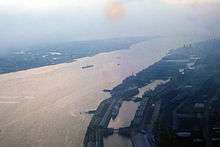
Most of the conurbation on both sides of the estuary is known as Merseyside. The estuary narrows between Liverpool and Birkenhead, where it is constricted to a width of 0.7 miles (1.1 km), between Albert Dock in Liverpool and the Woodside ferry terminal in Birkenhead. On the Liverpool side, Liverpool Docks stretch for over 7.5 miles (12.1 km), the largest enclosed interconnected dock system in the world. American author Herman Melville described Liverpool Docks as being comparable to the pyramids in the vast scale of their construction. The docks were built out into the river bed. The Mersey Docks and Harbour Board used granite from a quarry it owned in Scotland for construction of the quays. Birkenhead grew quickly in the 19th century following the introduction of steamships, the earliest being the wooden paddle steamer Elizabeth in 1815.[6] Docks were developed along with a shipbuilding industry, flour milling and soap manufacture on the river's Cheshire bank.[7]
Seaforth Dock, a freeport on the Liverpool side of the estuary where it meets Liverpool Bay, opened in 1971. The dock deals with around 500,000 containers, over 1.2 million tonnes of oil, over 2.5 million tonnes of grain and animal feed, 452,000 tonnes of wood per year. About 25% of all container traffic between the UK and USA passes through the port making it one of the most successful in the world and known as the "Atlantic Gateway".[8] Liverpool was the first UK port with radar assisted operations.[8]
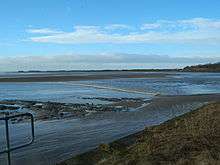
The river empties into Liverpool Bay on the Irish Sea, after a total course of 68 miles (109 km). From 4 metres (13.1 ft) neap tide to 10 metres (32.8 ft) spring tide, the River Mersey has the second highest tidal range in Britain – second only to the River Severn. The narrows in the river estuary between Dingle Point on the Liverpool banks to New Brighton on the Wirral, forces water to flow faster creating a deep channel along the section of river.
Strong river water currents have led to proposals for the future construction of a tidal barrage to generate electricity and create another crossing.[9] Very high spring tides can generate a tidal bore from Hale as far upstream as Warrington.
Taylor's Bank is a large sandbank extending out to sea on the north side of the channel entrance to the river on which many ships have come to grief over the years.[10][11]
River crossings
Historically the lowest bridging point on the Mersey was at Warrington where there has been a bridge since medieval times.[12][13] The first ferry across the estuary was introduced in medieval times by monks from Birkenhead Priory. They transported travellers or accommodated them at the priory in bad weather.
Countless lives were lost on the River Mersey until the advent of safe passage via bridges and tunnels.[14] Many of these deaths were of people who earned their living on the river, either as mariners or dock workers. The majority of mariners to die worked on the Mersey flat boats and drowned due to the weather conditions or poor craft maintenance, although many ordinary civilians perished too.[14] Another ferry existed at Runcorn Gap and by today's safety standards was highly dangerous. Passengers had to traverse wooden planks over the mud flats to reach the ferry boats which themselves were often poorly maintained and leaking. Even the steps down to the river bank were described as "beautifully slippery". In the dark the ferry was particularly worrying as there were few or no lights and the journey was only undertaken on a "needs must" basis. Complaints about the appalling conditions were reported in the local and national press consistently for over 40 years.[14]
In the early 19th century steam operated ferries were introduced.[7] The Mersey Ferry, managed and operated by Merseytravel, operates between Pier Head in Liverpool and Woodside in Birkenhead and Seacombe. It has become a tourist attraction offering cruises that provide an overview of the river and surrounding areas.[15]
The Mersey Railway completed its tunnel through the estuary's underlying Triassic sandstone using manual labour in 1885. Intended as a pneumatic railway, the company opted for steam trains from its opening until it was electrified in 1903. The centre of the running tunnel is between 30 feet (9.1 m) and 70 feet (21.3 m) below the river bed. The railway is now part of the Merseyrail network.[16] Two road tunnels pass under the estuary from Liverpool. By road, the Queensway Tunnel opened in 1934 connecting the city to Birkenhead, and the Kingsway Tunnel, opened in 1971, connects with Wallasey.
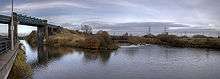
Further upstream, the Runcorn Railway Bridge over the river at Runcorn Gap was built in the 1860s for the London and North Western Railway on the mainline between London and Liverpool. It had a cantilevered footway providing an alternative crossing to a ferry.[17] In 1905 the now demolished Widnes-Runcorn Transporter Bridge opened and took cars and passengers via a cable car. The Silver Jubilee Bridge, completed in 1961, is immediately adjacent.[18]
East of Warrington, the M6 motorway crosses the river and the Manchester Ship Canal on the Thelwall Viaduct. When the viaduct opened in 1963, it was the longest motorway bridge in England.[19] A second viaduct alongside opened in 1995; northbound traffic uses the old viaduct and southbound the new.
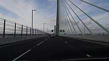
A new 6-lane bridge, the "Mersey Gateway", between Runcorn and Widnes began its construction phase in May 2014 and opened just after midnight on 14 October 2017.[4] At the same time the Silver Jubilee Bridge was closed to undergo maintenance for approximately 6–12 months, but will remain open to pedestrians and cyclists.[20] The new Mersey Gateway bridge uses tolls and the existing Silver Jubilee Bridge will also be tolled.
Environment
Water quality in the Mersey was severely affected by industrialisation, and in 1985, the Mersey Basin Campaign was established to improve water quality and encourage waterside regeneration. In 2002, oxygen levels that could support fish along the entire length were recorded for the first time since industry began on the Mersey.[21]
In 2009 it was announced that the river is "cleaner than at any time since the industrial revolution" and is "now considered one of the cleanest [rivers] in the UK".[22]
Sediment pollution
Persistent organic and mercury (Hg) pollution contained within sediments of the Mersey estuary have been evaluated by British Geological Survey.[23][24] Mersey river sediments from outer to inner estuary (Alfred Dock to Widnes) contain a variety of common organic pollutants, including polyaromatic hydrocarbons (PAH) with concentrations which fall in the middle of the range of similarly industrial-urban river-estuaries.[23] The distribution of individual PAH compounds suggests that the Mersey has contaminants mainly derived from combustion sources such as vehicle exhaust as well as coal burning. The distribution of the toxic heavy metal Mercury (Hg) has been assessed by measuring 203 sediments taken from shallow cores (0.4 – 1.6 m) extracted from both the main river and adjacent salt marshes.[24] The average amount of Hg in the Mersey was found to be 2 mg/kg with the highest amounts of 5 mg/kg occurring below the surface at concentrations harmful to sediment dwelling biota. The vertical rise and fall in Hg pollution observed at four Mersey salt marshes indicated a decline in metal pollution since the 1980s.[24]
Fauna
Salmon have returned to the river[25] and have been seen jumping at Woolston and Howley Weirs between September and November. Salmon parr and smolt have been caught in the Mersey's tributaries, the River Goyt and the River Bollin.[26] Atlantic grey seals from Liverpool Bay occasionally venture into the estuary[27] along with bottlenose dolphin and harbour porpoise. Otter pawprints have been observed near Fiddlers Ferry.[28] Other fish in the estuary include Cod, Whiting, Dab, Plaice and Flounder.[29] Dogfish, Mackerel and Tope feed on Shrimp and Whitebait in the estuary.[29] For ducks, the estuary is important to Shelducks and Teal.[30] Waders include Redshank, Black-tailed godwit, Dunlin, Pintail and Turnstone.[31][32]
Navigation
Capt. William Gill of the Isle of Man Steam Packet Company, charted a safe, navigable channel (the Victoria Channel) through the treacherous uncharted waters of the estuary in 1836.[33]
Since the construction of the Manchester Ship Canal, large commercial vessels do not usually navigate the estuary beyond Garston on the north bank, or the locks into the ship canal at Eastham. Deep-water channels are maintained to both. Until the early 20th century, commercial traffic bound for further upstream carried cargo in large flat-bottomed sailing barges known as Mersey Flats to Howley Wharf in Warrington and (via the Sankey Canal) to St Helens. Motor barges delivered to riverside factories at Warrington until at least the 1970s, but nowadays only pleasure craft and yachts use the upper estuary and the tidal river where a number of sailing clubs are based. On most high tides, seagoing yachts with masts raised can navigate as far upstream as Fiddlers Ferry – about 3.1 mi (5.0 km) downstream of Warrington – where there is a small marina accessed via a river lock. Although river craft can continue upstream to Howley Weir, there are no landing or mooring facilities. Before construction of the ship canal, a lock bypassing Howley Weir allowed navigation further upstream via a straight "cut" avoiding a meander around Woolston.
Recreation
The Mersey Valley Countryside Warden Service manages local nature reserves such as Chorlton Ees and Sale Water Park recreational sites and provides an educational service along the Mersey from Manchester to the Manchester Ship Canal. [34]
It is possible to canoe on parts of the river between Stockport and Carrington.[35] Liverpool Sailing Club located at Garston Coastal Park on the north bank of the estuary has a 1000 feet slipway giving access to river for water sports.[36]
The wooded suburban stretch of the river from above Howley Weir to Woolston is also used for recreational and competitive rowing, operated from the Warrington Rowing Club.
Angling has become popular on some stretches of the river as fish such as perch, barbel, grayling, carp, roach, chub, trout, pike, bream and dace have been caught. Warrington Anglers Association have fishing rights on a large stretch of the River through most of Warrington. Prince Albert Angling Society also have a small stretch near Rixton.
The river has also faced problems regarding the poaching of fish despite a strict 'catch and release' policy imposed on anglers for ecological reasons which applies to most UK waterways.[37]
In popular culture
The river gave its name to Merseybeat, developed by bands from Liverpool, notably the Beatles. In 1965 it was the subject of the top-ten hit single "Ferry Cross the Mersey" by Gerry and the Pacemakers, and a musical film of the same name. The Liverpool poets published an anthology of their work, The Mersey Sound, in 1967.
The river's stretch through Manchester is the main theme in the Stone Roses song "Mersey Paradise", included on the B-side of the 12" version of their 1989 hit "She Bangs the Drums", and on their 1992 compilation album Turns into Stone.
The Tall ships' fleet has visited the Mersey on four occasions, first in 1984, then in 1992, 2008 and 2012.[38][39]
Religious significance
The Mersey is considered sacred by British Hindus, and worshipped in a similar way to the River Ganges. Festival of Immersion ceremonies are held annually on the river, in which clay figures representing the Hindu Lord Ganesha, the elephant deity riding a mouse, are submerged in the river from a ferry boat. Followers throw flowers, pictures and coins into the river.[40][41]
Tributaries
From its lowest point, moving upstream, confluences and tributaries of the Mersey catchment include:
- The Birket
- River Fender
- Prenton Brook
- Arrowe Brook
- Greasby Brook
- Newton Brook
- Greasby Brook
- River Fender
- River Dibbin
- Clatter Brook
- River Gowy
- Hornsmill Brook
- River Weaver
- River Dane
- River Wheelock
- River Croco
- River Dane
- Ram's Brook
- Bowers Brook
- Sankey Brook
- Padgate Brook
- Morris Brook
- Spittle Brook
- Thelwall Brook
- Fishington Brook
- River Bollin
- River Dean
- Marsh Brook
- Red Brook
- Glaze Brook/River Glaze
- River Irwell
- River Medlock
- River Roch
- River Beal
- River Spodden
- River Irk
- River Croal
- Old Eea Brook
- Stromford Brook
- Chorlton Brook
- Barrow Brook
- Gatley Brook
- Micker Brook
- River Tame
- River Goyt
- River Etherow
- River Sett
- River Kinder
- Twigg Brook
References
- "Mersey Estuary". Ramsar Sites Information Service. Retrieved 25 April 2018.
- Arrowsmith, Peter (1997). Stockport: a History. Stockport: Stockport Metropolitan Borough Council. p. 21. ISBN 978-0-905164-99-1.
- Mills, A D (1998). A dictionary of English place-names. Oxford: Oxford University Press. p. 240. ISBN 978-0-19-280074-9.
- "Mersey Gateway Bridge is now open | The Mersey Gateway Project". www.merseygateway.co.uk. Retrieved 27 October 2017.
- John Stockdale, 1794, Map of the Environs of Mottram-in-Longdendale
- Mersey ferries (PDF), Liverpool Museums, retrieved 24 August 2012
- River Mersey, National Oceanography Centre, archived from the original on 2 February 2012, retrieved 24 August 2012
- "Merseyside History, Seaforth Dock". Mersey Reporter. Archived from the original on 14 July 2011.
- http://www.merseytidalpower.co.uk/content/mersey-tidal-power-feasibility-study
- "Liverpool (Approaches, Docks and Marina): Liverpool docks and Marina 2018: Visitmyharbour.com". www.visitmyharbour.com.
- Blott, Simon J. (2006). "Long-term morphological change and its causes in the Mersey Estuary, NW England". Geomorphology. 81 (1–2): 185–206. doi:10.1016/j.geomorph.2006.04.008.
- Warrington Background and analysis, merseyforest.org.uk, archived from the original on 19 June 2013, retrieved 25 August 2012
- Warrington Bridge, Engineering timelines, retrieved 25 August 2012
- Title; Across the Gap. Author; Jean M. Morris. Year 2016. Publisher; Springfield Farrihy Publishing; pp. 204–237
- "River Explorer Cruises". Mersey Ferries. Archived from the original on 23 July 2010. Retrieved 27 August 2012.
- Mersey Railway, Engineering Timelines, retrieved 25 August 2012
- Runcorn Rail Bridge, Engineering Timelines, retrieved 25 August 2012
- Historic England, "Runcorn Widnes Road Bridge (1130421)", National Heritage List for England, retrieved 25 August 2012
- M6 Warrington to Preston (J20 to J29), accessed on 4 August 2012
- "Future of the Silver Jubilee Bridge | The Mersey Gateway Project". www.merseygateway.co.uk. Retrieved 27 October 2017.
- "Mersey cleanest for 200 years". BBC News. 9 May 2003.
- Smith, Mark (24 September 2009). "Mersey 'cleanest since industrial revolution'". Runcorn Weekly News. Trinity Mirror North West & North Wales. p. 7.
- Vane, C.H., Harrison, I., Kim, A.W. (2007), "Polycyclic aromatic hydrocarbons (PAHs) and polychlorinated biphenyls (PCBs) in sediments from the Mersey Estuary, U.K.", Science of the Total Environment, 374 (1): 112–126, doi:10.1016/j.scitotenv.2006.12.036, PMID 17258286CS1 maint: multiple names: authors list (link)
- Vane, C.H. Jones, D.G., and Lister T.R. (2009), "Mercury contamination in surface sediments and sediment cores of the Mersey Estuary, UK.", Marine Pollution Bulletin, 58 (6): 940–946, doi:10.1016/j.marpolbul.2009.03.006, PMID 19356771CS1 maint: multiple names: authors list (link)
- Ikediashi, Charles (2012). "The origins of Atlantic salmon (Salmo salar L.) recolonizing the River Mersey in northwest England". Ecology and Evolution. 2 (10): 2537–2548. doi:10.1002/ece3.353. PMC 3492779. PMID 23145338.
- Billington, Sam. "Salmon behaviour in the Mersey Catchment" (PDF). Environment Agency. Archived from the original (PDF) on 28 March 2014.
- Atlantic grey seal, Cheshire Region Biodiversity Project, archived from the original on 6 August 2012, retrieved 25 August 2012
- "Otters return to once-polluted River Mersey", BBC News, The BBC, 23 November 2011, retrieved 25 August 2012
- "Making the most of the Mersey" (PDF). Liverpool Hope University. p. 25. Archived from the original (PDF) on 31 August 2003.
- "Mersey Estuary". RSPB. Retrieved 5 March 2016.
- "Flocking to the Mersey" (PDF). Mersey Basin. Retrieved 5 March 2016.
- "Waterbird population trend analysis of the Mersey Estuary SPA, Mersey Narrows & North Wirral Foreshore pSPA and Ribble & Alt Estuaries SPA". Natural England. Retrieved 5 March 2016.
- Discovering the Channel, isle-of-man.com, retrieved 25 August 2012
- Welcome to the Mersey Valley Countryside Warden Service, Mersey Valley Countryside Warden Service, archived from the original on 21 September 2012, retrieved 27 August 2012
- Canoe trail of the River Mersey, Canoe England, retrieved 27 August 2012
- Liverpool Sailing Club, Liverpool Sailing Club, retrieved 27 August 2012
- "Pair guilty of illegal fish poaching". Warrington Guardian. 5 July 2013. Retrieved 21 November 2015.
- "Tall Ships to return to Liverpool after River Mersey event added", Liverpool Daily Post, retrieved 27 August 2012
- BBC. "Tall Ships". www.bbc.co.uk. Retrieved 24 August 2019.
- "River Mersey festival celebrates Hindus birthday of Lord Ganesh". Liverpool Daily Post. 23 September 2010. Archived from the original on 20 September 2012.
- "River marks religious ceremony". BBC News. 14 September 2008.
Further reading
- Hills, Graham H. (1858). Essay on the hydrography of the Mersey Estuary. Liverpool: George McCorquodale & Co.
- Various well-known experts (1888). Industrial rivers of the United Kingdom. London: T. Fisher Unwin. pp. 19–44.
External links
| Wikimedia Commons has media related to River Mersey. |
- River Mersey Information
- Howley Lock
- "Salmon behaviour in the Mersey Catchment" at environment-agency.gov.uk
- Chisholm, Hugh, ed. (1911). . Encyclopædia Britannica (11th ed.). Cambridge University Press.
- Thorp, Robert. Mersey Built: The Role of Merseyside in the American Civil War. Wilmington: Vernon Press, 2017.