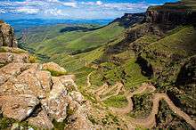
Mountain pass
A mountain pass is a navigable route through a mountain range or over a ridge. Since many of the world's mountain ranges have presented formidable barriers to travel, passes have played a key role in trade, war, and both human and animal migration throughout Earth's history. At lower elevations it may be called a hill pass. The highest vehicle-accessible pass in the world appears to be Mana Pass, located in the Himalayas on the border between India and Tibet, China.
Overview

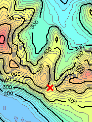
Mountain passes make use of a gap, saddle, or col (also sometimes a notch, the low point in a ridge). A topographic saddle is analogous to the mathematical concept of a saddle surface, with a saddle point marking the highest point between two valleys and the lowest point along a ridge.[2][3] On a topographic map, passes are characterized by contour lines with an hourglass shape, which indicates a low spot between two higher points.[4]
Passes are often found just above the source of a river, constituting a drainage divide. A pass may be very short, consisting of steep slopes to the top of the pass, or may be a valley many kilometres long, whose highest point might only be identifiable by surveying.
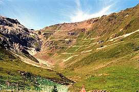
Roads have long been built through passes, as well as railways more recently. Some high and rugged passes may have tunnels bored underneath a nearby mountainside (like the Eisenhower Tunnel bypassing Loveland Pass in the Rockies) to allow faster traffic flow throughout the year.
The top of a pass is frequently the only flat ground in the area, and is a high vantage point. In some cases this makes it a preferred site for buildings. If a national border follows a mountain range, a pass over the mountains is typically on the border, and there may be a border control or customs station, and possibly a military post as well. For instance Argentina and Chile share the world's third-longest international border, 5,300 kilometres (3,300 mi) long. The border runs north–south along the Andes mountains, with a total of 42 mountain passes.[5][6] On a road over a pass, it is customary to have a small roadside sign giving the name of the pass and its elevation above mean sea level.
As well as offering relatively easy travel between valleys, passes also provide a route between two mountain tops with a minimum of descent. As a result, it is common for tracks to meet at a pass; this often makes them convenient routes even when travelling between a summit and the valley floor. Passes traditionally were places for trade routes, communications, cultural exchange, military expeditions etc. A typical example is the Brenner pass in the Alps.
Some mountain passes above the tree line have problems with snow drift in the winter. This might be alleviated by building the road a few meters above the ground, which will make snow blow off the road.
Synonyms
There are many words for pass in the English-speaking world. In the United States, pass is very common in the West, the word gap is common in the southern Appalachians, notch in parts of New England, and saddle in northern Idaho.[7] Scotland has the Gaelic term bealach (anglicised "balloch"), while Wales has the similar bwlch (both being British Celtic languages). In the Lake District of north-west England, the term hause is often used, although the term pass is also common—one distinction is that a pass can refer to a route, as well as the highest part thereof, while a hause is simply that highest part, often flattened somewhat into a high-level plateau.
Around the world
There are thousands of named passes around the world, some of which are well-known, such as the Great St. Bernard Pass at 2,473 metres (8,114 ft) in the Alps, the Chang La at 5,360 metres (17,590 ft), and the Khardung La at 5,359 metres (17,582 ft) in Jammu and Kashmir, India. The roads at Mana Pass at 5,610 metres (18,410 ft) and Marsimik La at 5,582 metres (18,314 ft), on and near the China-India border respectively, appear to be world's two highest motorable passes. Khunjerab Pass between Pakistan and China at 4,693 metres (15,397 ft) is also a high-altitude motorable mountain pass. One of the famous but non-motorable mountain pass include Thorong La at 5,416 metres (17,769 ft) in Annapurna Conservation Area, Nepal.
Gallery
 Agua Negra Pass (Argentina/Chile).
 The Bealach na Bà linking Applecross in the Scottish North-west Highlands.
 Dead Woman's Pass on the Inca Trail to Machu Picchu in Peru
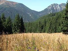 Pass in Tatras (Ornak, Poland).
 Zádieľska tiesňava Pass in Slovak Karst (Slovakia).
 Trail from Manang to Mustang via Thorong La pass
See also
- Abra del Acay – Mountain pass in Argentina
- Bealach na Bà - Mountain pass in North-west Scotland
- Col – The lowest point on a mountain ridge between two peaks
- Defile – A narrow pass or gorge between mountains or hills
- List of mountain passes – Wikipedia list article
- Saddle point
- Tōge, passes in Japan
- Water gap
- Wind gap
References
- 53°4′52.8″N 4°7′57″W, height contours from SRTM data.
- Eberhart, Mark E. (2004). Why Things Break: Understanding the World by the Way it Comes Apart. Random House. p. 232. ISBN 978-1-4000-4883-0. Retrieved 6 November 2010.
- Bishop, Michael P.; Shroder, John F. (2004). Geographic Information Science and Mountain Geomorphology. Springer. pp. 86–87. ISBN 978-3-540-42640-0. Retrieved 6 November 2010.
- Harvey, Mark William Thornton; Simer, Peter (1999). The National Outdoor Leadership School Wilderness Guide: The Classic Handbook. Simon & Schuster. p. 185. ISBN 978-0-684-85909-5. Retrieved 6 November 2010.
- "Principales Pasos Nacionales e Internacionales – Estado de los Pasos Fronterizos" (in Spanish). Gendarmería Nacional Argentina. Archived from the original on 28 March 2010. Retrieved 4 March 2010.
- "Pasos - Chile" (in Spanish). Gendarmería Nacional Argentina. Archived from the original on 2007-07-18. Retrieved 4 March 2010.
- Map showing "saddle" names in Idaho