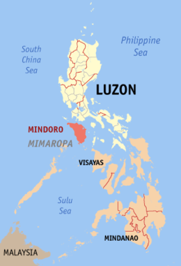
Mindoro
Mindoro is the seventh largest island in the Philippines by land area with a total of 10,571 km2 ( 4,082 sq.mi ) and with a total population of 1,331,473 as of 2015. It is located off the southwestern coast of Luzon and northeast of Palawan. Mindoro is divided into two provinces: Occidental Mindoro and Oriental Mindoro. San Jose is the largest settlement on the island with a total population of 143,430 inhabitants as of 2015. The southern coast of Mindoro forms the northeastern extremum of the Sulu Sea.[3] Mount Halcon is the highest point on the island, standing at 8,484 feet (2,586 m) above sea level located in Oriental Mindoro. Mount Baco is the island's second highest mountain with an elevation of 8,163 feet (2,488 m), located in the province of Occidental Mindoro.
 Location within the Philippines | |
| Geography | |
|---|---|
| Location | South East Asia |
| Coordinates | 12°55′49″N 121°5′40″E |
| Archipelago | Philippines |
| Adjacent bodies of water |
|
| Area | 10,571.8 km2 (4,081.8 sq mi)[1] |
| Area rank | 73rd |
| Coastline | 618.8 km (384.5 mi) |
| Highest elevation | 2,586 m (8,484 ft) |
| Highest point | Mount Halcon |
| Administration | |
Philippines | |
| Provinces |
|
| Largest settlement | San Jose (pop. 143,430) |
| Demographics | |
| Population | 1,331,473 (2015)[2] |
| Pop. density | 117.2/km2 (303.5/sq mi) |
| Ethnic groups |
|
History
_(14772309735).jpg)
In past times, it has been called Ma-i or Mait by Han Chinese traders. Indigenous groups are called Mangyans. The Spaniards called the place as Mina de Oro (meaning "gold mine") from where the island got its current name. According to the late historian William Henry Scott, an entry in the official history of the Sung Dynasty for the year 972 mentions Ma-i as a state which traded with China. Other Chinese records referring to Ma-i or Mindoro appear in the years that follow.[4]
The products that Mindoro traders exchanged with the Chinese included "beeswax, cotton, true pearls, tortoise shell, medicinal betelnuts and yu-ta [jute?] cloth" for Chinese porcelain, trade gold, iron pots, lead, copper, colored glass beads and iron needles.[4]
The island was briefly invaded by the Sultanate of Brunei and housed Moro settlements[5] before the Spanish invaded and Christianized the population. Afterwards, the area was depopulated due to wars between the Spaniards and the Moros from Mindanao who sought to enslave the hispanized people and to re-islamize the island.[6][7] Consequently, most of the population fled to nearby Batangas and the once rich towns of Mindoro fell to ruin.[6] In the seventeenth century, Giovanni Francesco Gemelli Careri visited the island.[8] In 1898, Mindoro joined in the Philippine Revolution against Spain due to the influx of rebels settling into the island from Cavite and Bataan. Local patriotism died down however during the American occupation of the Philippines and the Japanese era.
The island was the location of the Battle of Mindoro in World War II.
Nevertheless, upon Philippine independence, the area recovered and from 1920 to 1950, the island was a single province with Calapan City as the provincial capital. In 1950, it was partitioned into its two present-day provinces, Occidental Mindoro and Oriental Mindoro,[9] following a referendum.
Economy
The economy of Mindoro is largely based on agriculture. Products consist of a wide variety of fruits, such as citrus, bananas, lanzones, rambutan and coconuts, grains (rice and corn), sugarcane, peanuts, fish (catfish, milkfish and tilapia), livestock and poultry. Logging and the mining of marble and copper also thrive.
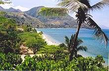
Tourism is a lucrative business as well, with locations such as Apo Reef National Park, Lubang Island, Puerto Galera, Sabang Beach and Mount Halcon. Puerto Galera's beaches are the island's most known tourist attraction and are widely visited.
Culture
The principal language in Mindoro is Tagalog, although in some parts it has been greatly influenced by the native Mangyan and Visayan languages. Visayan and Mangyan languages, too, are spoken on the island, as are Ilocano, Bicolano, and some foreign languages – e.g., English, Hokkien (a national dialect of Chinese), and to a lesser extent, Spanish.
The following indigenous languages (all of them being part of the Philippine branch of the Malayo-Polynesian languages family, like also like Ilocano, Bicolano, and the nationally designated official Filipino dialect of Tagalog) are spoken in Mindoro:
- Northern Mindoro languages – 16,000 speakers
- Iraya – 10,000 speakers
- Alangan – 2,150 speakers
- Tadyawan – 4,200 speakers
- Southern Mindoro languages – 30,000 speakers
- Buhid – 8,000 speakers
- Tawbuid – 8,000 speakers
- Hanuno'o – 14,000 speakers
- Visayan languages
- Ratagnon language – 2 speakers
Only the indigenous Mangyan language spoken in the southern part of the island is not part of the Philippine branch, but it is still a Malayo-Polynesian languages, historically developed separately from a common Proto-Malay substrate but under the influence of very ancient and more extensive contacts with Sino-Tibetan languages and cultures (from which a significant part of the native tribes seem to originate), and to a lesser extent with Indo-Aryan languages. Today, however, their local language is under strong influence of other Philippines languages (and notably with dominant Tagalog) and the more recent influence of English.
The common religions on the island fall under Christianity. The religion of the indigenous Mangyan population is animism. Though they are into animism as a principal religion, the Roman Catholic Church in some of Mindoro's parts is also active, so are a few independent subdivisions, like Iglesia Ni Cristo and Philippine Independent Church, as well as the Baptist Church.
Fauna
Mindoro is also home to the tamaraw or Mindoro dwarf buffalo (Bubalus mindorensis), which is endemic to the island. The tamaraw is a bovine related to the water buffalo (carabao) and is an endangered species.
Bibliography
- C.Michael Hogan. 2011. Sulu Sea. Encyclopedia of Earth. Eds. P.Saundry & C.J.Cleveland. Washington DC
References
- "Islands of Philippines". Island Directory. United Nations Environment Programme. Retrieved 22 May 2015.
- "Total Population by Province, City, Municipality and Barangay: as of May 1, 2010" (PDF). 2010 Census of Population and Housing. National Statistics Office. Archived from the original (PDF) on 11 March 2016. Retrieved 22 May 2015.
- C.Michael Hogan. 2011. Sulu Sea
- Scott, William Henry. (1984). "Societies in Prehispanic Philippines". Prehispanic Source Materials for the Study of Philippine History. Quezon City: New Day Publishers. p. 70. ISBN 971-10-0226-4.
- Prof. Cesar A. Majul attests to the existence of Bornean settlements in Manila and construes that some of the rulers found by the Spaniards were themselves Borneans. He in fact cites that as late as 1574, the Borneans and their allies, the Sulus, continued to extract tribute from the natives of Mindoro, thus this practice must have been going on for quite some time. Cf. Muslims in the Philippines, (Quezon City: University of the Philippines Press, 1973), pp. 72.,78; ·
- Lopez, Violeta B. (April 1974). "Culture Contact and Ethnogenesis in Mindoro up to the End of the Spanish Rule" (PDF). Asian Studies, Volume XII, Number 1. Retrieved 3 February 2017.
- Majul, op. cit., p. 108.
- Mirabeau, Honoré (1867). Erotika Biblion. Chevalier de Pierrugues. Chez tous les Libraries.
- "Republic Act No. 505 – An Act to Create the Provinces of Oriental Mindoro and Occidental Mindoro". Chan Robles Virtual Law Library. 13 June 1950. Retrieved 9 March 2016.
External links

| Wikisource has the text of The New Student's Reference Work article "Mindoro". |

- "Map of Mindoro" showing towns and major mountain tops